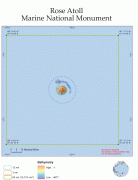
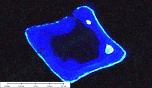
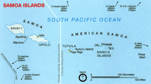
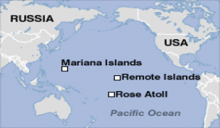
Rose Atoll (Rose Atoll)
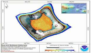
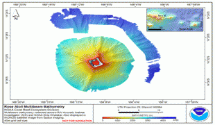
Rose Atoll, sometimes called Rose Island or Motu O Manu ("Bird Island") by people of the nearby Manu'a Islands, is an oceanic atoll within the U.S. territory of American Samoa. An uninhabited wildlife refuge, it is the southernmost point belonging to the United States. The land area is just 0.05 km2 at high tide. The total area of the atoll, including lagoon and reef flat amounts to 6.33 km2. Just west of the northernmost point is a channel into the lagoon, about 40 m wide. There are two islets on the northeastern rim of the reef, larger Rose Island in the east (3.5 m high) and the non-vegetated Sand Island in the north (1.5 m high). The Rose Atoll Marine National Monument that lies on the two outstanding islands of the Atoll is managed cooperatively between the U.S. Fish and Wildlife Service and the government of American Samoa.
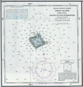
The earliest Western sighting was June 13, 1722, during the voyage of Jacob Roggeveen, who called it Vuil Eiland "useless island." The name Rose Island comes from its sighting by Louis de Freycinet in 1819. He named it after his wife Rose. While the second woman to circumnavigate the globe, Rose de Freycinet was the first to tell her tale. In his official report Louis de Freycinet records that 'I named Rose Island, from the name of someone who is extremely dear to me'. Soon afterwards, in 1824, it was seen by the expedition under Otto von Kotzebue, who named it Kordinkov after his First Lieutenant.
The earliest Western sighting was June 13, 1722, during the voyage of Jacob Roggeveen, who called it Vuil Eiland "useless island." The name Rose Island comes from its sighting by Louis de Freycinet in 1819. He named it after his wife Rose. While the second woman to circumnavigate the globe, Rose de Freycinet was the first to tell her tale. In his official report Louis de Freycinet records that 'I named Rose Island, from the name of someone who is extremely dear to me'. Soon afterwards, in 1824, it was seen by the expedition under Otto von Kotzebue, who named it Kordinkov after his First Lieutenant.
Map - Rose Atoll (Rose Atoll)
Map


Country - American_Samoa
 |
 |
American Samoa consists of five main islands and two coral atolls; the largest and most populous island is Tutuila, with the Manuʻa Islands, Rose Atoll and Swains Island also included in the territory. All islands except for Swains Island are part of the Samoan Islands, The total land area is 199 sqkm, slightly more than Washington, D.C. As of 2022, the population of American Samoa is approximately 45,443 people, of whom the vast majority are indigenous ethnic Samoans. Most American Samoans are bilingual and can speak English and Samoan fluently.
Currency / Language
| ISO | Currency | Symbol | Significant figures |
|---|---|---|---|
| USD | United States dollar | $ | 2 |
| ISO | Language |
|---|---|
| EN | English language |
| SM | Samoan language |
| TO | Tongan language |