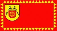
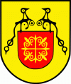
Rankovce Municipality (Opština Rankovce)
 |
 |
Rankovce municipality is located in the northeastern part of North Macedonia. It covers an area of 242 km².
The municipality borders Serbia to the north, Kriva Palanka Municipality to the east, Kratovo Municipality to the south and Staro Nagoričane Municipality to the west.
It has a significant geostrategic position because it borders Serbia to the north and Bulgaria indirectly, through Kriva Palanka municipality, to the east. An important road passes through it connecting the southern Balkans to Istanbul and Asia Minor, today known as the east-west corridor.
The municipality is connected through the south-west highway with Kumanovo (50 km) and Skopje (80 km). It is 20 km east to Kriva Palanka, 60 km to the Bulgarian border crossing Kjustendil and 25 km south to Kratovo.
It lies on the Slavishko Pole, a large plain that was a former lake in the Pliocene age, and to the north and south is surrounded by mountains. The climate is moderate-continental driven by the mountain ranges and the influence of the Aegean Sea through the river of Kriva Reka. The average temperature is 10.2 °C. Through the year, the warmest month is July with average temperature of 20.0 °C, while the coldest month is January with average temperature of 0.3 °C.
The soil of this area is very heterogeneous. There are many springs, rivers and streams due to the relatively high altitude and soil makeup. The most powerful is the Turanic spring at an altitude of 1,800m. Other notable springs are Carev Vrv (Kriva Reka), Bela Voda and Kalin Kamen.
The whole territory is a drainage-basin for the river Kriva Reka. Other smaller rivers (Kiselichka, Kriljanska and Durachka) pour into the Kriva Reka.
Map - Rankovce Municipality (Opština Rankovce)
Map


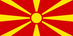
Country - Republic_of_Macedonia
 |
 |
The region's history begins with the kingdom of Paeonia, a mixed Thraco-Illyrian polity. In the late sixth century BC, the area was subjugated by the Persian Achaemenid Empire, then incorporated into the Kingdom of Macedonia in the fourth century BC. The Roman Republic conquered the region in the second century BC and made it part of the larger province of Macedonia. The area remained part of the Byzantine Empire, but was often raided and settled by Slavic tribes beginning in the sixth century of the Christian era. Following centuries of contention between the Bulgarian, Byzantine, and Serbian Empires, it was part of the Ottoman Empire from the mid-14th until the early 20th century, when, following the Balkan Wars of 1912 and 1913, the modern territory of North Macedonia came under Serbian rule.
Currency / Language
| ISO | Currency | Symbol | Significant figures |
|---|---|---|---|
| MKD | Macedonian denar | ден | 2 |
| ISO | Language |
|---|---|
| SQ | Albanian language |
| MK | Macedonian language |
| SR | Serbian language |
| TR | Turkish language |
