Map - Kumasi

Kumasi
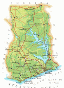
Kumasi (historically spelled Comassie or Coomassie, usually spelled Kumase in Twi) is a city in the Ashanti Region, and is among the largest metropolitan areas in Ghana. Kumasi is located in a rain forest region near Lake Bosomtwe, and is the commercial, industrial, and cultural capital of the historical Ashanti Empire. Kumasi is approximately 300 mi north of the Equator and 100 mi north of the Gulf of Guinea. Kumasi is alternatively known as "The Garden City" because of its many species of flowers and plants in the past. It is also called Oseikrom (Osei Tutu's the first town).

Kumasi is the second-largest city in Ghana, after the capital, Accra. The Central Business District of Kumasi includes areas such as Adum, Bantama, Asawasi, Pampaso and Bompata (popularly called Roman Hill), with a concentration of banks, department stalls, and hotels. Economic activities in Kumasi include financial and commercial sectors, pottery, clothing and textiles. There is a significant timber processing community in Kumasi serving the domestic market. Bantama High Street and Prempeh II Street in Bantama and Adum, respectively, are the business and entertainment hubs in Kumasi.

 
Map - Kumasi
Map
Google - Map - Kumasi
Google
Google Earth - Map - Kumasi
Google Earth
Nokia - Map - Kumasi
Nokia
Openstreetmap - Map - Kumasi
Openstreetmap
Mapa-de-la-Ciudad-de...
3875x4998
mapas.owje.com
txu-oclc-6595921-nb3...
3875x4998
www.lib.utexas.edu
Hoja-Kumasi-del-Mapa...
5000x3785
mapas.owje.com
txu-oclc-6595921-nb3...
5000x3785
www.lib.utexas.edu
3605815747_9c73f8cd4...
4891x3048
farm4.staticflickr.c...
Ashanti_districts.pn...
816x1056
upload.wikimedia.org
karta-over-accra.jpg
829x1024
www.travelforum.se
Ashanti-Campaign-190...
860x749
www.ctesiphon.com
BeforeAdiebebaNeighb...
621x893
troutsfarm.com
City-Maps_Page_08.jp...
625x813
mci.ei.columbia.edu
ghana_map.jpg
626x769
www.107aircadets.org
City-Maps_Page_09.jp...
606x783
mci.ei.columbia.edu
City-Maps_Page_06.jp...
603x774
mci.ei.columbia.edu
City-Maps_Page_07.jp...
614x730
mci.ei.columbia.edu
05_Africa_Ghana_Keny...
536x700
www.plkeene.com
kumasi-climograph.gi...
543x661
www.kumasi.climatemp...
Kumasi-Metropolitan1...
640x413
mofa.gov.gh
3605815747_41c7c8cd6...
640x399
farm4.staticflickr.c...
map-ghana6.jpg
405x558
easytrackghana.com
Wa%2BKumasi.png
542x381
3.bp.blogspot.com
Country - Ghana
Flag of Ghana
Ghana, officially the Republic of Ghana, is a country in West Africa. It abuts the Gulf of Guinea and the Atlantic Ocean to the south, sharing borders with Ivory Coast in the west, Burkina Faso in the north, and Togo in the east. It covers an area of 238535 km2, spanning biomes that range from coastal savannas to tropical rainforests. With over 32 million inhabitants, Ghana is the second-most populous country in West Africa, after Nigeria.

The Bono state existed in the area that is modern day Ghana during the 11th century. Kingdoms and empires such as Kingdom of Dagbon in the north and the Ashanti Empire in the south emerged over the centuries. Beginning in the 15th century, the Portuguese Empire, followed by other European powers, contested the area for trading rights, until the British ultimately established control of the coast by the 19th century. Following over a century of colonial resistance, the current borders of the country took shape, encompassing 4 separate British colonial territories: Gold Coast, Ashanti, the Northern Territories, and British Togoland. These were unified as an independent dominion within the Commonwealth of Nations. On 6th March 1957, Ghana became the first country in Sub-Saharan Africa to achieve sovereignty. Ghana subsequently became influential in decolonisation efforts and the Pan-African movement.
Currency / Language  
ISO Currency Symbol Significant figures
GHS Ghanaian cedi ₵ 2
Neighbourhood - Country  
  •  Burkina Faso 
  •  Côte d'Ivoire 
  •  Togo