Kili Island (Kili Island)
Kili Island or Kili Atoll (Marshallese: Kōle, ) is a small, 81 ha (0.93 km2) island located in the Marshall Islands in the Pacific Ocean. It is the temporary home of 548 inhabitants who are descended from islanders who originally lived on Bikini Atoll. They were relocated when they agreed to let the U.S. government temporarily use their home for nuclear testing in 1945. Kili Island became their home after two prior relocations failed. The island does not have a natural lagoon and cannot produce enough food to enable the islanders to be self-sufficient. It is part of the legislative district of the Ralik Chain of the Marshall Islands. The island is approximately 48 km southwest of Jaluit. It is one of the smallest islands in the Marshall Islands.
Captain Thomas Dennet of the British vessel Britannia sighted the atoll in 1797 on route from Australia to China and named it Hunter Island.
Kili Atoll was claimed by the Empire of Germany along with the rest of the Marshall Islands in 1884. After World War I, the island came under the South Seas Mandate of the Empire of Japan. Following the end of World War II, it came under the control of the United States as part of the Trust Territory of the Pacific Islands.
Map - Kili Island (Kili Island)
Map
Country - Marshall_Islands
 |
 |
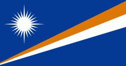
| Flag of the Marshall Islands | |
The country's population of 42,050 people (at the 2021 World Bank Census ) is spread out over five islands and 29 coral atolls, comprising 1,156 individual islands and islets. The capital and largest city is Majuro. It has the largest portion of its territory composed of water of any sovereign state, at 97.87%. The islands share maritime boundaries with Wake Island to the north, Kiribati to the southeast, Nauru to the south, and the Federated States of Micronesia to the west. About 52.3% of Marshall Islanders (27,797 at the 2011 Census) live on Majuro. In 2016, 73.3% of the population were defined as being "urban". The UN also indicates a population density of 295 PD/km2, and its projected 2020 population is 59,190.
Currency / Language
| ISO | Currency | Symbol | Significant figures |
|---|---|---|---|
| USD | United States dollar | $ | 2 |
| ISO | Language |
|---|---|
| EN | English language |
| MH | Marshallese language |


