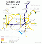
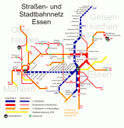
Map - Essen

Essen
Essen (Latin: Assindia) is the central and, after Dortmund, second-largest city of the Ruhr, the largest urban area in Germany. Its population of 0 makes it the fourth-largest city of North Rhine-Westphalia after Cologne, Düsseldorf and Dortmund, as well as the ninth-largest city of Germany. Essen lies in the larger Rhine-Ruhr Metropolitan Region and is part of the cultural area of Rhineland. Because of its central location in the Ruhr, Essen is often regarded as the Ruhr's "secret capital". Two rivers flow through the city: in the north, the Emscher, the Ruhr area's central river, and in the south, the Ruhr River, which is dammed in Essen to form the Lake Baldeney (Baldeneysee) and Lake Kettwig (Kettwiger See) reservoirs. The central and northern boroughs of Essen historically belong to the Low German (Westphalian) language area, and the south of the city to the Low Franconian (Bergish) area (closely related to Dutch).

Essen is seat to several of the region's authorities, as well as to eight of the 100 largest publicly held German corporations by revenue, including three DAX-listed corporations. Essen is often considered the energy capital of Germany with E.ON and RWE, Germany's largest energy providers, both headquartered in the city. Essen is also known for its impact on the arts through the respected Folkwang University of the Arts, its Zollverein School of Management and Design, and the Red Dot industrial product design award. In early 2003, the universities of Essen and the nearby city of Duisburg (both established in 1972) were merged into the University of Duisburg-Essen with campuses in both cities and a university hospital in Essen. In 1958, Essen was chosen to serve as the seat to a Roman Catholic diocese (often referred to as Ruhrbistum or diocese of the Ruhr).

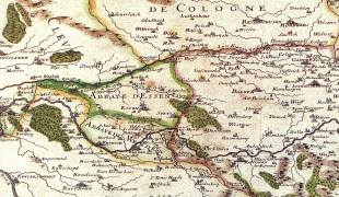
Founded around 845, Essen remained a small town within the sphere of influence of an important ecclesiastical principality (Essen Abbey) until the onset of industrialization. The city then—especially through the Krupp family iron works—became one of Germany's most important coal and steel centers. Essen, until the 1970s, attracted workers from all over the country; it was the fifth-largest city in Germany between 1929 and 1988, peaking at over 730,000 inhabitants in 1962. Following the region-wide decline of heavy industries in the last decades of the 20th century, the city has seen the development of a strong tertiary sector of the economy. The most notable witness of this Strukturwandel (structural change) is the Zollverein Coal Mine Industrial Complex, which had once been the largest of its kind in Europe. Ultimately closed in 1993, both the coking plant and the mine have been inscribed in the list of UNESCO World Heritage Sites since 2001.

Notable accomplishments of the city in recent years include the title of European Capital of Culture on behalf of the whole Ruhr area in 2010 and the selection as the European Green Capital for 2017.
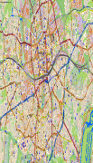
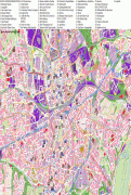
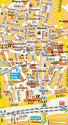
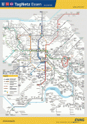
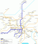
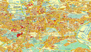
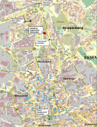
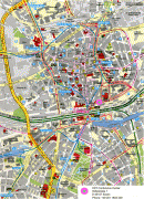
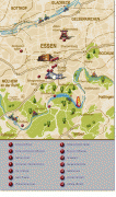
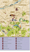
 
Map - Essen
Map
Google - Map - Essen
Google
Google Earth - Map - Essen
Google Earth
Nokia - Map - Essen
Nokia
Openstreetmap - Map - Essen
Openstreetmap
campus-duisburg-mls-...
2644x2248
www.uni-due.de
lp_campus_essenConfr...
2333x2280
www.auto-ui.org
1.png
1428x2500
www.mappedplanet.com
0.png
1342x2000
www.mappedplanet.com
essen-metro-map.png
1447x1500
mapa-metro.com
essen-metro-map.png
1446x1500
planetolog.com
Essen_Map_1681.jpg
1611x1209
upload.wikimedia.org
Stadtplan-Zentrum-Es...
1000x1831
www.hot-map.com
EVAG_Essen_STN.jpg
1131x1600
2.bp.blogspot.com
essen_metro_map4.png
1109x1368
www.mapametro.com
1280px-Essen_Map_168...
1280x961
upload.wikimedia.org
essen-map-metro-1.pn...
945x1109
www.orangesmile.com
stadtplan_essen.jpg
1000x1000
www.bilderfotos.com
MapIem.gif
856x1124
www.iem.uni-due.de
Essen-Street-Map.jpg
769x1063
mappery.com
Essen-Street-Map.jpg
769x1063
www.mappery.com
essen-map.jpg
700x1079
www.planetware.com
essen-map-0.jpg
650x1100
www.orangesmile.com
essen-map-0.jpg
560x948
www.orangesmile.com
map-essen-www.png
600x837
m2.geometry.de
Country - Germany
Flag of Germany
Germany, officially the Federal Republic of Germany, is a country in Central Europe. It is the second-most populous country in Europe after Russia, and the most populous member state of the European Union. Germany is situated between the Baltic and North seas to the north, and the Alps to the south; it covers an area of 357022 km2, with a population of almost 84 million within its 16 constituent states. Germany borders Denmark to the north, Poland and the Czech Republic to the east, Austria and Switzerland to the south, and France, Luxembourg, Belgium, and the Netherlands to the west. The nation's capital and most populous city is Berlin and its financial centre is Frankfurt; the largest urban area is the Ruhr.

Various Germanic tribes have inhabited the northern parts of modern Germany since classical antiquity. A region named Germania was documented before AD 100. In 962, the Kingdom of Germany formed the bulk of the Holy Roman Empire. During the 16th century, northern German regions became the centre of the Protestant Reformation. Following the Napoleonic Wars and the dissolution of the Holy Roman Empire in 1806, the German Confederation was formed in 1815.
Currency / Language  
ISO Currency Symbol Significant figures
EUR Euro € 2
ISO Language
DE German language
Neighbourhood - Country  
  •  Austria 
  •  Belgium 
  •  Czech Republic 
  •  Denmark 
  •  France 
  •  Luxembourg 
  •  Netherlands 
  •  Poland 
  •  Switzerland