Cascades Region (Cascades Region)
As of 2019, the population of the region was 812,062. As of 2007, the literacy rate in the region was 20%, compared to a national average of 28.3%. The coverage of cereal need compared to the total production of the region was 117%.
Most of Burkina Faso is a wide plateau formed by riverine systems and is called falaise de Banfora. There are three major rivers, the Red Volta, Black Volta and White Volta, which cuts through different valleys. The climate is generally hot, with unreliable rains across different seasons. Gold and quartz are common minerals found across the country, while manganese deposits are also common. The dry season is usually from October to May and rains are common during the wet season from June to September. The soil texture is porous and hence the yield is also poor. The average elevation is around 200 m to 300 m above mean sea level. The region contains Mount Tenakourou, which is the country's highest peak with an elevation of 747 m. Among West African countries, Burkina Faso has the largest elephant population and the country is replete with game reserves. The southern regions are more tropical in nature and have savannah and forests. The principal river is the Black Volta, that originates in the southern region and drains into Ghana. The areas near the rivers usually have flies like tsetse and similium, which are carriers of sleep sickness and river blindness. The average rainfall in the region is around 100 cm compared to northern regions that receive only 25 cm rainfall.
Map - Cascades Region (Cascades Region)
Map


Country - Burkina_Faso
 |
 |
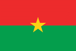
| Flag of Burkina Faso | |
The largest ethnic group in Burkina Faso is the Mossi people, who settled the area in the 11th and 13th centuries. They established powerful kingdoms such as the Ouagadougou, Tenkodogo, and Yatenga. In 1896, it was colonized by the French as part of French West Africa; in 1958, Upper Volta became a self-governing colony within the French Community. In 1960, it gained full independence with Maurice Yaméogo as president. Throughout the decades post independence, the country was subject to instability, droughts, famines and corruption. Various coups have also taken place in the country, in 1966, 1980, 1982, 1983, 1987, and twice in 2022, in January and in September, as well as an attempt in 1989 and another in 2015.
Currency / Language
| ISO | Currency | Symbol | Significant figures |
|---|---|---|---|
| XOF | West African CFA franc | Fr | 0 |
| ISO | Language |
|---|---|
| FR | French language |