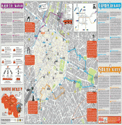
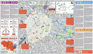
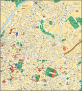
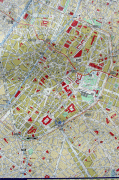
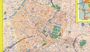
City of Brussels (Brussels)
 |
 |
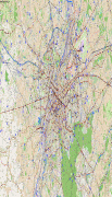
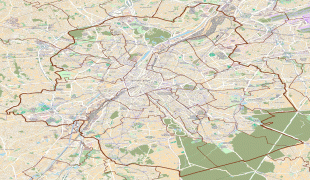
Besides the central historic town located within the Pentagon, the City of Brussels covers some of the city's immediate outskirts within the greater Brussels-Capital Region, namely the former municipalities of Haren, Laeken, and Neder-Over-Heembeek to the north, as well as the Avenue Louise/Louizalaan and the Bois de la Cambre/Ter Kamerenbos park to the south-east, where it borders municipalities in Flanders.
, the City of Brussels had a total population of 176,545. The total area is 32.61 km2 which gives a population density of 5475 PD/km2. As of 2007, there were approximately 50,000 registered non-Belgians in the City of Brussels. In common with all of Brussels' municipalities, it is legally bilingual (French–Dutch).
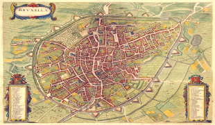
Historically, the City of Brussels was simply defined, being the area within the second walls of Brussels, the modern-day Small Ring (Brussels' inner ring road). As the city grew, the surrounding villages grew as well, eventually growing into a contiguous city, though the local governments retained control of their respective areas.
The construction of the Avenue Louise/Louizalaan was commissioned in 1847 as a monumental avenue bordered by chestnut trees that would allow easy access to the popular recreational area of the Bois de la Cambre/Ter Kamerenbos. However, fierce resistance to the project was put up by the town of Ixelles (which was then still separate from Brussels) through whose land the avenue was supposed to run. After years of fruitless negotiations, Brussels finally annexed the narrow band of land needed for the avenue plus the Bois de la Cambre itself in 1864. That decision accounts for the unusual southeastern protrusion of the City of Brussels and for Ixelles being split in two separate parts. Part of the Université libre de Bruxelles (ULB)'s Solbosch campus is also part of the City of Brussels, partially accounting for the bulge in the southeast end.
Unlike most of the municipalities in Belgium, the ones located in the Brussels-Capital Region were not merged with others during mergers occurring in 1964, 1970, and 1975. However, a few neighbouring municipalities have been merged into the City of Brussels, including Haren, Laeken and Neder-Over-Heembeek in 1921. These comprise the northern bulge in the municipality. To the south-east is also a strip of land along the Avenue Louise that was annexed from Ixelles.
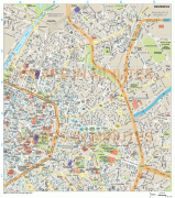
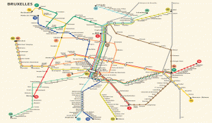
Map - City of Brussels (Brussels)
Map


Country - Belgium
 |
 |
| Flag of Belgium | |
Belgium is a sovereign state and a federal constitutional monarchy with a parliamentary system. Its institutional organization is complex and is structured on both regional and linguistic grounds. It is divided into three highly autonomous regions: the Flemish Region (Flanders) in the north, the Walloon Region (Wallonia) in the south, and the Brussels-Capital Region. Brussels is the smallest and most densely populated region, as well as the richest region in terms of GDP per capita. Belgium is also home to two main linguistic communities: the Flemish Community, which constitutes about 60 percent of the population, and the French Community, which constitutes about 40 percent of the population. A small German-speaking Community, numbering around one percent, exists in the East Cantons. The Brussels-Capital Region is officially bilingual in French and Dutch, although French is the dominant language.
Currency / Language
| ISO | Currency | Symbol | Significant figures |
|---|---|---|---|
| EUR | Euro | € | 2 |
| ISO | Language |
|---|---|
| NL | Dutch language |
| FR | French language |
| DE | German language |