Argyle International Airport (Argyle International Airport)
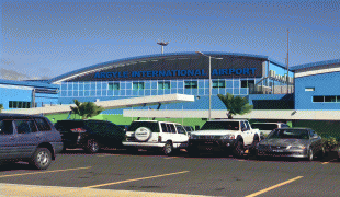
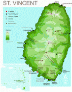
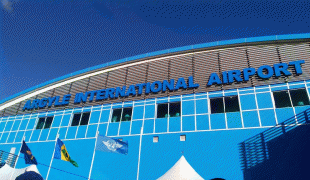
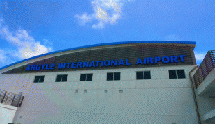
Argyle International Airport (often referred to as Argyle Airport or simply AIA) is an international airport on the island of Saint Vincent in the Caribbean nation of Saint Vincent and the Grenadines. It is located in Argyle, about 5.17 mi from the capital Kingstown.
The airport is one of St. Vincent and the Grenadines' most important infrastructure assets and the country's first international airport. It is the largest international gateway into the country and connects St. Vincent and the Grenadines to major airports such as Miami International Airport, John F. Kennedy International Airport, Toronto Pearson International Airport, London Heathrow Airport as well as other airports in the Caribbean.
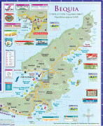
It is the largest of five airports in the multi-island nation of St. Vincent and the Grenadines, the others being J. F. Mitchell Airport in Bequia, Canouan Airport, Mustique Airport and Union Island Airport, all in the Grenadines. Argyle International Airport serves as a major gateway to the Grenadines, with several airlines operating an extensive network of direct domestic flights from AIA to all destinations in the Grenadines.
The airport is the second solar powered airport in the Caribbean, following V. C. Bird International Airport in Antigua.
The project broke ground on 13 August 2008, with a work team of Vincentians and Cubans (nicknamed the "Chatoyer-Che Contingent" by Vincentian Prime Minister Ralph Gonsalves), and the airport officially opened on 14 February 2017 when a Dynamic Airways charter flight became the first international aircraft to touch down at Argyle. The Argyle International Airport replaced the much smaller E.T. Joshua Airport as St. Vincent and the Grenadines’ principal airport. During the construction of the new airport, the International Airport Development Company (IADC) faced numerous challenges and controversies, causing major delays in the construction process. This resulted in the airport being completed five years after the originally forecasted completion date.
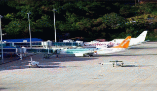
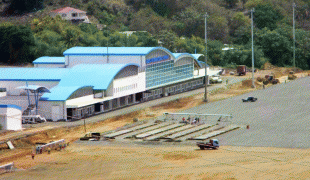
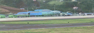
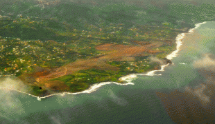
Argyle International Airport (AIA) was built on expropriated land in a rural part of St. Vincent's southeast coast, in response to the growing airport traffic needs that the E.T. Joshua Airport could not accommodate and also, because the latter had reached its saturation point with no physical space for further growth. The new airport is able to handle 1.5 million passengers per year, more than four times the capacity at E.T. Joshua and offers 23 commercial spaces, three restaurants and several spots for kiosks. The airport is expected to increase the accessibility to this multi-island destination and be a key economic driver for the country, attracting direct flights from Canada, the US, the UK and more, fueling investments.
The airport commenced full operations on 14 February 2017, replacing the decommissioned E.T. Joshua Airport. Argyle International Airport is the only airport in St. Vincent and the Grenadines that offers international scheduled flights and is also served by scheduled, low-fare, business and charter carriers, with many services operated to the U.S. and Canada. It also supports corporate and general aviation. Argyle International Airport is the largest capital project in the history of the country, with an estimated cost of construction of XCD$700 million (USD$259 million) and an actual estimated value in excess of XCD$1 billion.
The airport is one of St. Vincent and the Grenadines' most important infrastructure assets and the country's first international airport. It is the largest international gateway into the country and connects St. Vincent and the Grenadines to major airports such as Miami International Airport, John F. Kennedy International Airport, Toronto Pearson International Airport, London Heathrow Airport as well as other airports in the Caribbean.
It is the largest of five airports in the multi-island nation of St. Vincent and the Grenadines, the others being J. F. Mitchell Airport in Bequia, Canouan Airport, Mustique Airport and Union Island Airport, all in the Grenadines. Argyle International Airport serves as a major gateway to the Grenadines, with several airlines operating an extensive network of direct domestic flights from AIA to all destinations in the Grenadines.
The airport is the second solar powered airport in the Caribbean, following V. C. Bird International Airport in Antigua.
The project broke ground on 13 August 2008, with a work team of Vincentians and Cubans (nicknamed the "Chatoyer-Che Contingent" by Vincentian Prime Minister Ralph Gonsalves), and the airport officially opened on 14 February 2017 when a Dynamic Airways charter flight became the first international aircraft to touch down at Argyle. The Argyle International Airport replaced the much smaller E.T. Joshua Airport as St. Vincent and the Grenadines’ principal airport. During the construction of the new airport, the International Airport Development Company (IADC) faced numerous challenges and controversies, causing major delays in the construction process. This resulted in the airport being completed five years after the originally forecasted completion date.
Argyle International Airport (AIA) was built on expropriated land in a rural part of St. Vincent's southeast coast, in response to the growing airport traffic needs that the E.T. Joshua Airport could not accommodate and also, because the latter had reached its saturation point with no physical space for further growth. The new airport is able to handle 1.5 million passengers per year, more than four times the capacity at E.T. Joshua and offers 23 commercial spaces, three restaurants and several spots for kiosks. The airport is expected to increase the accessibility to this multi-island destination and be a key economic driver for the country, attracting direct flights from Canada, the US, the UK and more, fueling investments.
The airport commenced full operations on 14 February 2017, replacing the decommissioned E.T. Joshua Airport. Argyle International Airport is the only airport in St. Vincent and the Grenadines that offers international scheduled flights and is also served by scheduled, low-fare, business and charter carriers, with many services operated to the U.S. and Canada. It also supports corporate and general aviation. Argyle International Airport is the largest capital project in the history of the country, with an estimated cost of construction of XCD$700 million (USD$259 million) and an actual estimated value in excess of XCD$1 billion.
| IATA Code | SVD | ICAO Code | TVSA | FAA Code | |
|---|---|---|---|---|---|
| Telephone | (784) 456-5555 | Fax | |||
| Home page | Hyperlink |
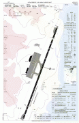
Map - Argyle International Airport (Argyle International Airport)
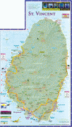
Map


Country - Saint_Vincent_and_the_Grenadines
 |
 |
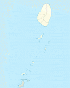
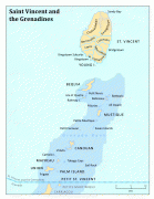
Its 369 km2 territory consists of the main island of Saint Vincent and, south of that, two-thirds of the northern part of the Grenadines, a chain of 32 smaller islands. Some of the Grenadines are inhabited—Bequia, Mustique, Union Island, Canouan, Petit Saint Vincent, Palm Island, Mayreau, Young Island—while others are not: Tobago Cays, Baliceaux, Battowia, Quatre, Petite Mustique, Savan and Petit Nevis. Most of Saint Vincent and the Grenadines lies within the Hurricane Alley.
Currency / Language
| ISO | Currency | Symbol | Significant figures |
|---|---|---|---|
| XCD | East Caribbean dollar | $ | 2 |
| ISO | Language |
|---|---|
| EN | English language |
| FR | French language |