Map - Aomori Prefecture (Aomori-ken)

Aomori Prefecture (Aomori-ken)
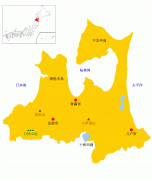
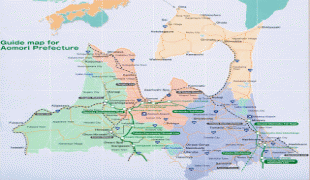
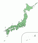
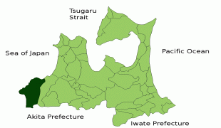
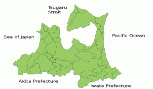
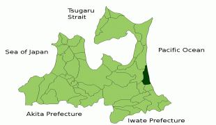
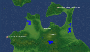
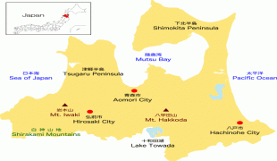
Aomori Prefecture (青森県) is a prefecture of Japan in the Tōhoku region. The prefecture's capital, largest city, and namesake is the city of Aomori. Aomori is the northernmost prefecture on Japan's main island, Honshu, and is bordered by the Pacific Ocean to the east, Iwate Prefecture to the southeast, Akita Prefecture to the southwest, the Sea of Japan to the west, and Hokkaido across the Tsugaru Strait to the north. Aomori Prefecture is the 8th-largest prefecture, with an area of 9,645.64 sqkm, and the 31st-most populous prefecture, with more than 1.2 million people. Approximately 45 percent of Aomori Prefecture's residents live in its two core cities, Aomori and Hachinohe, which lie on coastal plains. The majority of the prefecture is covered in forested mountain ranges, with population centers occupying valleys and plains. Aomori is the third-most populous prefecture in the Tōhoku region, after Miyagi Prefecture and Fukushima Prefecture. Mount Iwaki, an active stratovolcano, is the prefecture's highest point, at almost 1624.7 m.

Humans have inhabited the prefecture for at least 15,000 years, and the oldest evidence of pottery in Japan was discovered at the Jōmon period Odai Yamamoto I site. After centuries of rule by the Nanbu and Tsugaru clans, the prefecture was formed out of the northern part of Mutsu Province during the Meiji Restoration. Though the prefecture remains dominated by primary sector industries, it also serves as a transportation hub due to its location at the northern end of Honshu.

 
Map - Aomori Prefecture (Aomori-ken)
Map
Openstreetmap - Map - Aomori Prefecture
Openstreetmap
cmap.png
3229x3821
www.pref.aomori.lg.j...
Aomori-ken%2BMap-01....
1600x1449
1.bp.blogspot.com
Aomori-ken%2BMap-01....
1600x1449
3.bp.blogspot.com
Aomori-ken%252BMap-0...
1600x1449
1.bp.blogspot.com
Aomori-ken+Map-01.jp...
1600x1449
1.bp.blogspot.com
Map_of_the_prefectur...
1397x1593
upload.wikimedia.org
Japan_Aomori_large.p...
1397x1593
upload.wikimedia.org
Aomori-ken%2BMap-02....
1600x1232
3.bp.blogspot.com
Aomori-ken%2BMap-02....
1600x1232
3.bp.blogspot.com
Aomori-ken%252BMap-0...
1600x1232
3.bp.blogspot.com
Aomori-ken+Map-02.jp...
1600x1232
3.bp.blogspot.com
JP_Aomori_Prefecture...
1495x1060
wikitravel.org
Fukaura_in_Aomori_Pr...
1081x801
upload.wikimedia.org
AomoriMapCurrent.png
1081x801
upload.wikimedia.org
Misawa_in_Aomori_Pre...
1081x801
upload.wikimedia.org
2656152-3x2-940x627....
940x627
www.abc.net.au
oirase-river-flag-_m...
769x741
icdn.images.touristl...
map_aomori.gif
846x663
www2.gol.com
map_aomori.png
569x844
www.jalan.net
figure-map.gif
650x629
www.pref.aomori.lg.j...
Country - Japan
Flag of Japan
Japan (日本, or, and formally 日本国, Nihonkoku) is an island country in East Asia. It is situated in the northwest Pacific Ocean and is bordered on the west by the Sea of Japan, extending from the Sea of Okhotsk in the north toward the East China Sea, Philippine Sea, and Taiwan in the south. Japan is a part of the Ring of Fire, and spans an archipelago of 6852 islands covering 377,975 km2; the five main islands are Hokkaido, Honshu (the "mainland"), Shikoku, Kyushu, and Okinawa. Tokyo is the nation's capital and largest city, followed by Yokohama, Osaka, Nagoya, Sapporo, Fukuoka, Kobe, and Kyoto.

Japan is the eleventh most populous country in the world, as well as one of the most densely populated and urbanized. About three-fourths of the country's terrain is mountainous, concentrating its population of 124.8 million on narrow coastal plains. Japan is divided into 47 administrative prefectures and eight traditional regions. The Greater Tokyo Area is the most populous metropolitan area in the world, with more than 37.2 million residents.
Currency / Language  
ISO Currency Symbol Significant figures
JPY Japanese yen ¥ 0
ISO Language
JA Japanese language
Neighbourhood - Country  
Airport