地図 - Sussundenga District
地図
国
首都
国際空港
国旗
通貨
言語
ニュース
世界
アフリカ
モザンビーク
Manica Province
Sussundenga District
Sussundenga District
地図 - Sussundenga District
地図
地図 - Sussundenga District
Google
地図 - Sussundenga District
Google Earth
地図 - Sussundenga District
ビング
地図 - Sussundenga District
ノキア
地図 - Sussundenga District
オープンストリートマップ
地図 - Sussundenga District
Esri.WorldImagery
地図 - Sussundenga District
Esri.WorldStreetMap
地図 - Sussundenga District
OpenStreetMap.Mapnik
地図 - Sussundenga District
OpenStreetMap.HOT
地図 - Sussundenga District
OpenTopoMap
地図 - Sussundenga District
CartoDB.Positron
地図 - Sussundenga District
CartoDB.Voyager
地図 - Sussundenga District
OpenMapSurfer.Roads
地図 - Sussundenga District
Esri.WorldTopoMap
地図 - Sussundenga District
Stamen.TonerLite
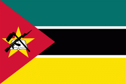
国 - モザンビーク
モザンビークの国旗
モザンビーク共和国(モザンビークきょうわこく)、通称モザンビークは、アフリカ大陸南東部に位置する共和制国家. 南に南アフリカ共和国、南西をエスワティニ、西にジンバブエ、北西にザンビアとマラウイ、北はタンザニアと国境を接する. 東はインド洋で、モザンビーク海峡内や対岸にマダガスカルとコモロ、フランス領のマヨットおよび無人島群の一部が存在する. 首都はマプトである.
国土面積は約79万9000平方キロメートル(日本のおよそ2倍)、人口は約3036万人で増加傾向にある.
地図 - モザンビーク
通貨 / 言語
ISO
通貨
シンボル
有効数字
MZN
メティカル
(Mozambican metical)
MT
2
ISO
言語
PT
ポルトガル語
(Portuguese language)
Neighbourhood - 国
エスワティニ
ザンビア
ジンバブエ
タンザニア
マラウイ
南アフリカ共和国
言語
Sussundenga District
(English)
Distretto di Sussundenga
(Italiano)
District de Sussundenga
(Français)
Sussundenga
(Português)
Sussundenga
(Español)
蘇森登加區
(中文)
Sussundengan piiri
(Suomi)