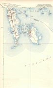
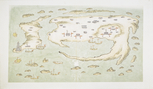
West Island (West Island)
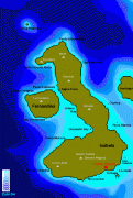
West Island (Malay: Pulau Panjang, Cocos Malay: Pulu Panjang), part of the South Keeling Islands, is the capital of the Cocos (Keeling) Islands, an Australian external territory in the Indian Ocean. The population is roughly 120, making it the third smallest capital in the world, and consists mainly of Europeans. It is less populous than Home Island, the only other inhabited island.
West Island was part of the Clunies-Ross plantation and an airstrip was built here during World War II. As well as all the government buildings, it contains the airport, a general store and tourist accommodation. In November 2013 it was revealed that the Australian Signals Directorate operates a listening station on West Island.
Cocos Islands District High School operates a primary and secondary campus on West Island. Most of the students of that campus originate from the Australian continent.
Map - West Island (West Island)
Map


Country - Cocos_(Keeling)_Islands
 |
 |
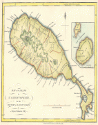
The territory consists of two atolls made up of 27 coral islands, of which only two – West Island and Home Island – are inhabited. The population of around 600 people consists mainly of Cocos Malays, who mostly practice Sunni Islam and speak a dialect of Malay as their first language. The territory is administered by the Australian federal government's Department of Infrastructure, Transport, Regional Development and Communications as an Australian external territory and together with Christmas Island (which is about 960 km to the east) forms the Australian Indian Ocean Territories administrative grouping. However, the islanders do have a degree of self-government through the local shire council. Many public services – including health, education, and policing – are provided by the state of Western Australia, and Western Australian law applies except where the federal government has determined otherwise. The territory also uses Western Australian postcodes.
Currency / Language
| ISO | Currency | Symbol | Significant figures |
|---|---|---|---|
| AUD | Australian dollar | $ | 2 |
| ISO | Language |
|---|---|
| EN | English language |
| MS | Malay language |