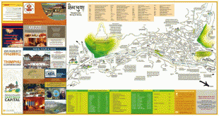
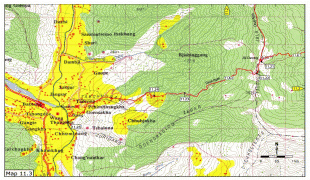
Thimphu
Thimphu (ཐིམ་ཕུག ) is the capital and largest city of Bhutan. It is situated in the western central part of Bhutan, and the surrounding valley is one of Bhutan's dzongkhags, the Thimphu District. The ancient capital city of Punakha was replaced by Thimphu as capital in 1955, and in 1961 Thimphu was declared as the capital of the Kingdom of Bhutan by the 3rd Druk Gyalpo Jigme Dorji Wangchuck.
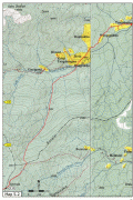
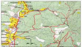
The city extends in a north–south direction on the west bank of the valley formed by the Wang Chhu, which flows out into India as the Raidāk River. Thimphu is the fifth highest capital in the world by altitude and ranges in altitude from 2248 m to 2648 m. Unusually for a capital city, Thimphu does not have its own airport, instead relying on the Paro Airport (connected by road some 52 km away).
Thimphu, as the political and economic center of Bhutan, has a dominant agriculture and livestock base, which contributes to 45% of the country's GNP. Tourism, though a contributor to the economy, is strictly regulated, maintaining a balance between the traditional, development and modernization. Thimphu contains most of the important political buildings in Bhutan, including the National Assembly of the newly-formed parliamentary democracy and Dechencholing Palace, the official Rtp Slot residence of the King, located to the north of the city. Thimphu is coordinated by the "Thimphu Structure Plan, 2002-2027", an urban development plan with the objective of protecting the fragile ecology of the valley. Some of this development was undertaken with financial assistance from the World Bank and Asian Development Bank.
The culture of Bhutan is fully reflected in Thimphu in literature, religion, customs, and national dress code, the monastic practices of the monasteries, music, and dance, and in the media. Tshechu is an important festival when mask dances, popularly known as Cham dances, are performed in the courtyards of the Tashichho Dzong in Thimphu. It is a four-day festival held every year in September or October, on dates corresponding to the Bhutanese calendar.
Before 1960, Thimphu consisted of a group of hamlets scattered across the valley including Motithang, Changangkha, Changlimithang, Langchupakha, and Taba, some of which constitute districts of the city today (see below for district details). In 1885, a battle was held at what is now the Changlimithang sports ground in Thimphu. The decisive victory opened the way for Ugyen Wangchuck, the first King of Bhutan to virtually control the whole country. Since this time the sports ground has been of major importance to the city; football, cricket matches and archery competitions take place there. The modern Changlimithang Stadium was built on the site in 1974. Under the Wangchuck Dynasty, the country enjoyed peace and progress under successive reformist monarchs. The third king, Jigme Dorji Wangchuck, reformed the old pseudo-feudal systems by abolishing serfdom, redistributing land, and reforming taxation. He also introduced many executive, legislative, and judiciary reforms. Reforms continued and in 1952 the decision was made to shift the capital from the ancient capital of Punakha to Thimphu. The fourth king, Jigme Singye Wangchuck, opened the country for development and India provided the needed impetus in this process with financial and other forms of assistance. In 1961, Thimphu officially became the capital of Bhutan.
Bhutan joined the Colombo Plan in 1962, the Universal Postal Union in 1969 and became a member of the United Nations in 1971. The presence of diplomatic missions and international funding organizations in Thimphu resulted in rapid expansion of Thimphu as a metropolis.
The fourth king, who had established the National Assembly in 1953, devolved all executive powers to a council of ministers elected by the people in 1998. He introduced a system of voting no confidence in the king, which empowered the parliament to remove the monarch. The National Constitution Committee in Thimphu started drafting the Constitution of the Kingdom of Bhutan in 2001. In 2005, the fourth king of Bhutan announced his decision to hand over the reins of his kingdom to his son Prince Jigme Khesar Namgyal Wangchuk. The coronation of the king was held in Thimphu at the refurbished Changlimithang Stadium and coincided with the centenary of the establishment of the House of Wangchuck. In 2008, this paved way for the transition from absolute monarchic rule to a parliamentary democratic constitutional monarchy, with Thimphu as the headquarters of the new government, with the national defined objective of achieving "Gross National Happiness" (GNH) concomitant with the growth of Gross National Product (GNP).
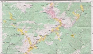
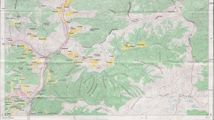
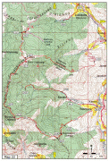
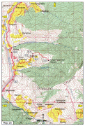
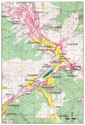
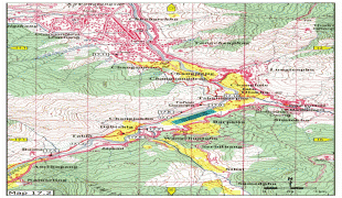
Map - Thimphu
Map


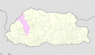

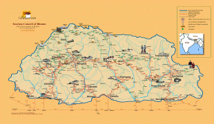


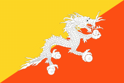
Country - Bhutan
 |
 |
| Flag of Bhutan | |
The subalpine Himalayan mountains in the north rise from the country's lush subtropical plains in the south. In the Bhutanese Himalayas, there are peaks higher than 7000 m above sea level. Gangkhar Puensum is Bhutan's highest peak and is the highest unclimbed mountain in the world. The wildlife of Bhutan is notable for its diversity, including the Himalayan takin and golden langur. The capital and largest city is Thimphu, holding close to 1/7th of the population.
Currency / Language
| ISO | Currency | Symbol | Significant figures |
|---|---|---|---|
| BTN | Bhutanese ngultrum | Nu | 2 |
| INR | Indian rupee | ₹ | 2 |
| ISO | Language |
|---|---|
| DZ | Dzongkha language |