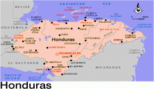
Tegucigalpa
 |
 |
Claimed on 29 September 1578 by the Spaniards, Tegucigalpa became the country's capital on October 30, 1880, under President Marco Aurelio Soto, when he moved the capital from Comayagua. The Constitution of Honduras, enacted in 1982, names the sister cities of Tegucigalpa and Comayagüela as a Central District to serve as the permanent national capital, under articles 8 and 295.
After the dissolution of the Federal Republic of Central America in 1841, Honduras became an individual sovereign nation with Comayagua as its capital. The capital was moved to Tegucigalpa in 1880. On January 30, 1937, Article 179 of the 1936 Honduran Constitution was changed under Decree 53 to establish Tegucigalpa and Comayagüela as a Central District.
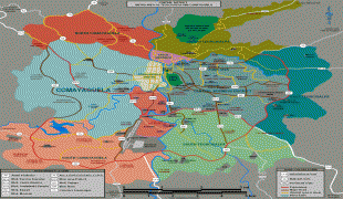
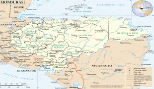
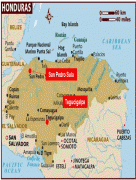
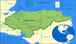
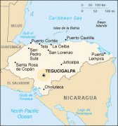
Tegucigalpa is located in the southern-central highland region known as the department of Francisco Morazán of which it is also the departmental capital. It is situated in a valley, surrounded by mountains. Tegucigalpa and Comayagüela, being sister cities, are physically separated by the Choluteca River. The Central District is the largest of the 28 municipalities in the Francisco Morazán department.
Tegucigalpa is Honduras' largest and most populous city as well as the nation's political and administrative center. Tegucigalpa is host to 25 foreign embassies and 16 consulates. It is the home base of several state-owned entities such as ENEE and Hondutel, the national energy and telecommunications companies, respectively. The city is also home to the country's most important public university, the National Autonomous University of Honduras, as well as the national soccer team. The capital's international airport, Toncontín,.
The Central District Mayor's Office (Alcaldia Municipal del Distrito Central) is the city's governing body, headed by a mayor and 10 aldermen forming the Municipal Corporation (Corporación Municipal). Being the department's seat as well, the governor's office of Francisco Morazán is also located in the capital. In 2008, the city operated on an approved budget of 1.555 billion lempiras (US$82,189,029). In 2009, the city government reported a revenue of 1.955 billion lempiras (US$103,512,220), more than any other capital city in Central America except Panama City.
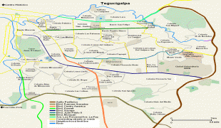
Tegucigalpa's infrastructure has not kept up with its population growth. Deficient urban planning, densely condensed urbanization, and poverty are ongoing problems. Heavily congested roadways, where road infrastructure is unable to efficiently handle over 400,000 vehicles, create havoc on a daily basis. Both national and local governments have taken steps to improve and expand infrastructure as well as to reduce poverty in the city.
Most sources indicate the origin and meaning of the word Tegucigalpa is derived from the Nahuatl language. The most widely accepted version suggests that it comes from the Nahuatl word Taguz-galpa, which means "hills of silver", but this interpretation is uncertain since the natives who occupied the region at the time were unaware of the existence of mineral deposits in the area.
Another source suggests that Tegucigalpa derives from another language in which it means painted rocks, as explained by Leticia Oyuela in her book Minimum History of Tegucigalpa. Other theories indicate it may derive from the term Togogalpa, which refers to tototi (meaning a small green parrot, in Nahuatl) and Toncontín, a small town near Tegucigalpa (toncotín was a Mexican dance of Nahuatl origin).
In Mexico, it is believed the word Tegucigalpa is from the Nahuatl word Tecuztlicallipan, meaning "place of residence of the noble" or Tecuhtzincalpan, meaning "place on the home of the beloved master".
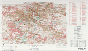
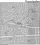
Map - Tegucigalpa
Map


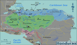


Country - Honduras
 |
 |
| Flag of Honduras | |
Honduras was home to several important Mesoamerican cultures, most notably the Maya, before the Spanish colonization in the sixteenth century. The Spanish introduced Catholicism and the now predominant Spanish language, along with numerous customs that have blended with the indigenous culture. Honduras became independent in 1821 and has since been a republic, although it has consistently endured much social strife and political instability, and remains one of the poorest countries in the Western Hemisphere. In 1960, the northern part of what was the Mosquito Coast was transferred from Nicaragua to Honduras by the International Court of Justice.
Currency / Language
| ISO | Currency | Symbol | Significant figures |
|---|---|---|---|
| HNL | Honduran lempira | L | 2 |
| ISO | Language |
|---|---|
| ES | Spanish language |