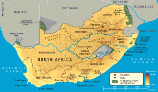
Map - South Africa

World >  Africa >  South Africa

South Africa

Flag of South Africa
South Africa, officially the Republic of South Africa (RSA), is the southernmost country in Africa. It is bounded to the south by 2,798 km of coastline of Southern Africa stretching along the South Atlantic and Indian Oceans; to the north by the neighbouring countries of Namibia, Botswana, and Zimbabwe; and to the east and northeast by Mozambique and Eswatini (Swaziland); and it surrounds the enclaved country of Lesotho. South Africa is the largest country in Southern Africa and the 25th-largest country in the world by land area and, with over 57 million people, is the world's 24th-most populous nation. It is the southernmost country on the mainland of the Old World or the Eastern Hemisphere. About 80 percent of South Africans are of Sub-Saharan African ancestry, divided among a variety of ethnic groups speaking different African languages, nine of which have official status. The remaining population consists of Africa's largest communities of European (White), Asian (Indian), and multiracial (Coloured) ancestry.

South Africa is a multiethnic society encompassing a wide variety of cultures, languages, and religions. Its pluralistic makeup is reflected in the constitution's recognition of 11 official languages, which is the fourth highest number in the world. Two of these languages are of European origin: Afrikaans developed from Dutch and serves as the first language of most coloured and white South Africans; English reflects the legacy of British colonialism, and is commonly used in public and commercial life, though it is fourth-ranked as a spoken first language. 
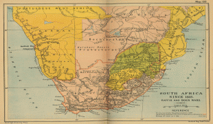
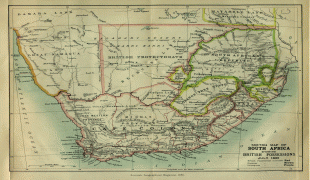
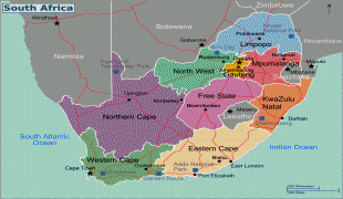
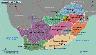
The country is one of the few in Africa never to have had a coup d'état, and regular elections have been held for almost a century. However, the vast majority of black South Africans were not enfranchised until 1994. During the 20th century, the black majority sought to recover its rights from the dominant white minority, with this struggle playing a large role in the country's recent history and politics. The National Party imposed apartheid in 1948, institutionalising previous racial segregation. After a long and sometimes violent struggle by the African National Congress (ANC) and other anti-apartheid activists both inside and outside the country, the repeal of discriminatory laws began in 1990.

Since 1994, all ethnic and linguistic groups have held political representation in the country's liberal democracy, which comprises a parliamentary republic and nine provinces. South Africa is often referred to as the "rainbow nation" to describe the country's multicultural diversity, especially in the wake of apartheid. The World Bank classifies South Africa as an upper-middle-income economy, and a newly industrialised country. Its economy is the second-largest in Africa, and the 34th-largest in the world. In terms of purchasing power parity, South Africa has the seventh-highest per capita income in Africa. However, poverty and inequality remain widespread, with about a quarter of the population unemployed and living on less than US$1.25 a day. Nevertheless, South Africa has been identified as a middle power in international affairs, and maintains significant regional influence.

The name "South Africa" is derived from the country's geographic location at the southern tip of Africa. Upon formation, the country was named the Union of South Africa in English, reflecting its origin from the unification of four formerly separate British colonies. Since 1961, the long form name in English has been the "Republic of South Africa". In Dutch, the country was named Republiek van Zuid-Afrika, replaced in 1983 by the Afrikaans Republiek van Suid-Afrika. Since 1994, the Republic has had an official name in each of its 11 official languages.

Mzansi, derived from the Xhosa noun umzantsi meaning "south", is a colloquial name for South Africa, while some Pan-Africanist political parties prefer the term "Azania".

 
Neighbourhood - Country  

Map - South Africa

Latitude / Longitude : 29° 0' 0" S / 24° 0' 0" E | Time zone : UTC+2 | Currency : ZAR | Telephone : 27  

Map

Google Earth-Map-South Africa
Google Earth
OpenStreetMap-Map-South Africa
OpenStreetMap
Map-South AfricaUn-south-africa.png
Un-south-africa.png
3037x2257
freemapviewer.org
Map-South Africaimage.jpg
image.jpg
1397x1846
freemapviewer.org
Map-South AfricaSouth_Africa-Regions_map.jpg
South_Africa-Regions...
2000x1501
freemapviewer.org
Map-South Africa2031px-South_Africa_relief_location_map.svg.jpg
2031px-South_Africa_...
2031x1741
freemapviewer.org
Map-South AfricaSouth_Africa_Topography.jpg
South_Africa_Topogra...
1578x1457
freemapviewer.org
Map-South Africa-large_detailed_topographical_map_of_south_africa.jpg
large_detailed_topog...
8295x6500
www.vidiani.com
Map-South Africa-South_Africa-Regions_map_ru.png
South_Africa-Regions...
3564x2676
upload.wikimedia.org
Map-South Africa-detailed_political_map_of_south_africa_with_cities_airports_roads_and_railroads.jpg
detailed_political_m...
2257x3037
www.vidiani.com
Map-South Africa-South-Africa-Road-Map.jpg
South-Africa-Road-Ma...
2920x2188
mappery.com
Map-South Africa-South-Africa-Road-Map.jpg
South-Africa-Road-Ma...
2920x2188
www.mappery.com
Map-South Africa-south_africa_1815.jpg
south_africa_1815.jp...
2220x1697
images.nationmaster....
Map-South Africa-south_africa_1885.jpg
south_africa_1885.jp...
1906x1648
www-users.york.ac.uk
Map-South Africa-Mapa-de-Sudafrica-1885-6378.jpg
Mapa-de-Sudafrica-18...
1906x1648
mapas.owje.com
Map-South Africa-south_africa_1885.jpg
south_africa_1885.jp...
1906x1648
images.nationmaster....
Map-South Africa-south_africa_1885.jpg
south_africa_1885.jp...
1906x1648
www.lib.utexas.edu
Map-South Africa-south_africa_1885.jpg
south_africa_1885.jp...
1906x1648
www.mapcruzin.com
Map-South Africa-South_Africa-Regions_map.png
South_Africa-Regions...
2000x1501
upload.wikimedia.org
Map-South Africa-South_Africa-Regions_map.png
South_Africa-Regions...
2000x1501
wikitravel.org
Map-South Africa-central_africa_pol_97.jpg
central_africa_pol_9...
1982x1442
www.lib.utexas.edu
Map-South Africa-map-union-south-east-africa-1935.jpg
map-union-south-east...
1383x1922
www.philatelicdataba...
Map-South Africa-South-Africa-on-Map.jpg
South-Africa-on-Map....
1800x1294
www.mycitybynight.co...
Map-South Africa-south-africa-1.png
south-africa-1.png
1650x1284
12.000.scripts.mit.e...
Map-South Africa-detailed_topographical_map_of_south_africa.jpg
detailed_topographic...
1500x1385
www.vidiani.com
Map-South Africa-map_of_south_africa_with_all_cities.jpg
map_of_south_africa_...
1367x1511
www.vidiani.com
Map-South Africa-SouthAfricaOMC.png
SouthAfricaOMC.png
1367x1511
upload.wikimedia.org
1 2 3 4 5 6 

Photograph

South Africa-Prehistoric archaeology-Maropeng visitor centre, Cradle of Humankind, South Africa
Prehistoric archaeology
Maropeng visitor centre, Cradle of Humankind, South Africa
South Africa-Bantu expansion-MapungubweHill
Bantu expansion
MapungubweHill
South Africa-Portuguese exploration-F. Benda-The planting of cross by Bartholomew Dias in 1488-0681 (cropped)
Portuguese exploration
F. Benda-The planting of cross by Bartholomew Dias in 1488-0681 (cropped)
South Africa-Dutch colonisation-Charles Bell - Jan van Riebeeck se aankoms aan die Kaap
Dutch colonisation
Charles Bell - Jan van Riebeeck se aankoms aan die Kaap
South Africa-British colonisation and the Great Trek-Charles Bell - Zoeloe-aanval op 'n Boerelaer - 1838
British colonisation and the Great Trek
Charles Bell - Zoeloe-aanval op 'n Boerelaer - 1838
South Africa-Boer Wars-Foto van oorlog
Boer Wars
Foto van oorlog
South Africa-Boer Wars-Boercamp1
Boer Wars
Boercamp1
South Africa-Beginning of apartheid-ApartheidSignEnglishAfrikaans
Beginning of apartheid
ApartheidSignEnglishAfrikaans
South Africa-End of apartheid-Frederik de Klerk with Nelson Mandela - World Economic Forum Annual Meeting Davos 1992
End of apartheid
Frederik de Klerk with Nelson Mandela - World Economic Forum Annual Meeting Davos 1992
South Africa-End of apartheid-Watching South Africa & France match at World Cup 2010-06-22 in Soweto 13
End of apartheid
Watching South Africa & France match at World Cup 2010-06-22 in Soweto 13
South Africa-End of apartheid-People's March Anti Xenophobia
End of apartheid
People's March Anti Xenophobia
South Africa-Geography-South Africa sat
Geography
South Africa sat
South Africa-Geography-Image depicting the Drakensberg
Geography
Image depicting the Drakensberg
South Africa-Geography-Namaqualand, Goegap 0035
Geography
Namaqualand, Goegap 0035
South Africa-Climate-South Africa Kppen
Climate
South Africa Kppen
South Africa-Biodiversity-South African Giraffes, fighting
Biodiversity
South African Giraffes, fighting
South Africa-Biodiversity-African Leopard Sabi Sands Fir0002 Oct18
Biodiversity
African Leopard Sabi Sands Fir0002 Oct18
South Africa-Conservation issues-Flora at Cape Peninsula
Conservation issues
Flora at Cape Peninsula
South Africa-Education-Mitchells-plain-schoolkids
Education
Mitchells-plain-schoolkids
South Africa-Government and politics-Photo of the Union Buildings
Government and politics
Photo of the Union Buildings
1 2 3 4 5 6 7 8 9 10 

Administrative subdivision

Country, State, Region,...

Island

 mapnall@gmail.com