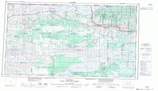
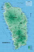
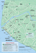
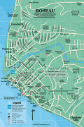
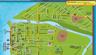
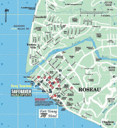
Roseau
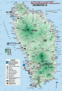
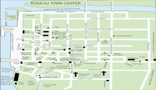
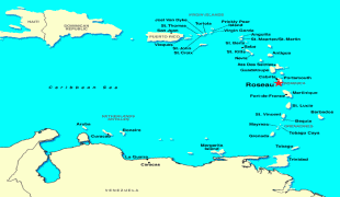
Roseau (Dominican Creole: Wozo) is the capital and largest city of Dominica, with a population of 14,725 as of 2011. It is a small and compact urban settlement, in the Saint George parish and surrounded by the Caribbean Sea, the Roseau River and Morne Bruce. Built on the site of the ancient Island Carib village of Sairi, it is the oldest and most important urban settlement on the island of Dominica.
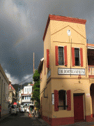
It is on the west (leeward) coast of Dominica and has a combination of modern and colonial French architecture.
Roseau is Dominica's most important port for foreign trade. Some exports include bananas, bay oil, vegetables, grapefruit, oranges, and cocoa. The service sector is also a large part of the local economy. There are several private institutions registered in Dominica, like Ross University, Ballsbridge University, international university for graduate studies, All Saints University, New World University, Western Orthodox University.
There is a prominent diocese called Roman Catholic Diocese of Roseau.
The city of Roseau sits on an alluvial fan formed hundreds of years ago as the Roseau River meandered across the area from what is now known as Newtown to its current location. Over the last 2,000 years, Amerindians migrating through the islands settled the area attracted by the nearby river. With the arrival of the Europeans in the 16th and 17th centuries, a small settlement was established by the French who, in their tradition of naming places after what they found there, used their name for the river reeds that grew along the banks. A plan was created for the settlement that mirrored examples in France where streets extended from a central point – what is today the Old Market – and spread out to the rest of the settlement.
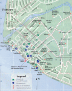
Conflict raged between the French and the British over the area on several occasions. The British gained a stronghold. By the late 18th and early 19th centuries, they set out plans for the city that included fortifications and government structures, the grid street system, and blocks and new urban areas to the north and south, known today as Potter's Ville and Newtown. Goodwill was established in the 1950s and Bath Estate in the early 1980s. Since then several new semi-urban settlements – such as Stock Farm, Castle Comfort, and Wall House – have been constructed around the existing ones. Some older settlements like Fond Cole and Canefield nowadays belong to the semi-urban area around Roseau.
The French influence can still be seen today, however, in its architecture and crooked streets that extend from the Old Market Plaza. Examples of the English influence is evident in architecture and street names.
It is on the west (leeward) coast of Dominica and has a combination of modern and colonial French architecture.
Roseau is Dominica's most important port for foreign trade. Some exports include bananas, bay oil, vegetables, grapefruit, oranges, and cocoa. The service sector is also a large part of the local economy. There are several private institutions registered in Dominica, like Ross University, Ballsbridge University, international university for graduate studies, All Saints University, New World University, Western Orthodox University.
There is a prominent diocese called Roman Catholic Diocese of Roseau.
The city of Roseau sits on an alluvial fan formed hundreds of years ago as the Roseau River meandered across the area from what is now known as Newtown to its current location. Over the last 2,000 years, Amerindians migrating through the islands settled the area attracted by the nearby river. With the arrival of the Europeans in the 16th and 17th centuries, a small settlement was established by the French who, in their tradition of naming places after what they found there, used their name for the river reeds that grew along the banks. A plan was created for the settlement that mirrored examples in France where streets extended from a central point – what is today the Old Market – and spread out to the rest of the settlement.
Conflict raged between the French and the British over the area on several occasions. The British gained a stronghold. By the late 18th and early 19th centuries, they set out plans for the city that included fortifications and government structures, the grid street system, and blocks and new urban areas to the north and south, known today as Potter's Ville and Newtown. Goodwill was established in the 1950s and Bath Estate in the early 1980s. Since then several new semi-urban settlements – such as Stock Farm, Castle Comfort, and Wall House – have been constructed around the existing ones. Some older settlements like Fond Cole and Canefield nowadays belong to the semi-urban area around Roseau.
The French influence can still be seen today, however, in its architecture and crooked streets that extend from the Old Market Plaza. Examples of the English influence is evident in architecture and street names.
Map - Roseau
Map


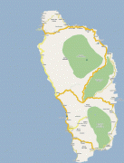
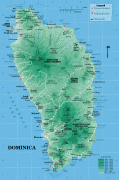

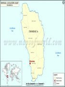

Country - Dominica
 |
 |
| Flag of Dominica | |
The island was settled by the Arawak arriving from South America in the fifth century. The Kalinago displaced the Arawak by the 15th century. Columbus is said to have passed the island on Sunday, 3 November 1493. It was later colonised by Europeans, predominantly by the French from the 1690s to 1763. The French imported enslaved people from West Africa to Dominica to work on coffee plantations. Great Britain took possession in 1763 after the Seven Years' War, and it gradually established English as its official language. The island gained independence as a republic in 1978.
Currency / Language
| ISO | Currency | Symbol | Significant figures |
|---|---|---|---|
| XCD | East Caribbean dollar | $ | 2 |
| ISO | Language |
|---|---|
| EN | English language |