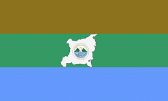
Región Autónoma del Atlántico Norte (Costa Caribe Norte)
 |
 |
The North Autonomous Caribbean Coast has a Regional Council of representatives of different political parties, such as the Sandinistas (FSLN) and YATAMA (ethnic indigenous party), as well as all the municipalities. They hold sessions in an Assembly in Puerto Cabezas.
The North Autonomous Caribbean Coast, in addition to Mestizos, contains populations from different indigenous groups, including the Miskitos, Mayangnas, and others. Regional official languages are Creole (Miskito Coast Creole and Rama Cay Creole), Miskito, Sumo (Mayangna and Ulwa), Garifuna, and Rama, in addition to the national official language of Spanish, most males in Puerto Cabezas speak some English from when it was a US fruit plantation.
The RACCN contains eight municipalities:
* 1) Bonanza
* 2) Mulukukú
* 3) Prinzapolka
* 4) Puerto Cabezas
* 5) Rosita
* 6) Siuna
Map - Región Autónoma del Atlántico Norte (Costa Caribe Norte)
Map


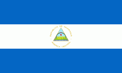
Country - Nicaragua
 |
 |
| Flag of Nicaragua | |
Originally inhabited by various indigenous cultures since ancient times, the region was conquered by the Spanish Empire in the 16th century. Nicaragua gained independence from Spain in 1821. The Mosquito Coast followed a different historical path, being colonized by the English in the 17th century and later coming under British rule. It became an autonomous territory of Nicaragua in 1860 and its northernmost part was transferred to Honduras in 1960. Since its independence, Nicaragua has undergone periods of political unrest, dictatorship, occupation and fiscal crisis, including the Nicaraguan Revolution of the 1960s and 1970s and the Contra War of the 1980s.
Currency / Language
| ISO | Currency | Symbol | Significant figures |
|---|---|---|---|
| NIO | Nicaraguan córdoba | C$ | 2 |
| ISO | Language |
|---|---|
| EN | English language |
| ES | Spanish language |
