Karnali Pradesh (Karnali Province)
Karnali Province (कर्णाली प्रदेश) is one of the seven federal provinces of Nepal formed by the new constitution which was adopted on 20 September 2015. The total area of the province is 27984 km2 covering 18.97% of the country, making it the largest province in Nepal. According to the 2011 Nepal census, the population of the province was 1,570,418, making it the least populous province in Nepal. It borders the Tibet Autonomous Region of China to the north, Gandaki Province to the east, Sudurpashchim Province to the west, and Lumbini Province to the south. Birendranagar with a population of 154,886 is both the province's capital and largest city.
The province's name is derived from the Karnali River, which flows through the province. A meeting of the provincial assembly on 25 February 2018 adopted the name Karnali for the province.
The province's name is derived from the Karnali River, which flows through the province. A meeting of the provincial assembly on 25 February 2018 adopted the name Karnali for the province.
Map - Karnali Pradesh (Karnali Province)
Map


Country - Nepal
 |
 |
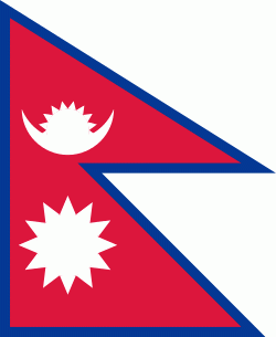
| Flag of Nepal | |
The name "Nepal" is first recorded in texts from the Vedic period of the Indian subcontinent, the era in ancient Nepal when Hinduism was founded, the predominant religion of the country. In the middle of the first millennium BC, Gautama Buddha, the founder of Buddhism, was born in Lumbini in southern Nepal. Parts of northern Nepal were intertwined with the culture of Tibet. The centrally located Kathmandu Valley is intertwined with the culture of Indo-Aryans, and was the seat of the prosperous Newar confederacy known as Nepal Mandala. The Himalayan branch of the ancient Silk Road was dominated by the valley's traders. The cosmopolitan region developed distinct traditional art and architecture. By the 18th century, the Gorkha Kingdom achieved the unification of Nepal. The Shah dynasty established the Kingdom of Nepal and later formed an alliance with the British Empire, under its Rana dynasty of premiers. The country was never colonised but served as a buffer state between Imperial China and British India. Parliamentary democracy was introduced in 1951 but was twice suspended by Nepalese monarchs, in 1960 and 2005. The Nepalese Civil War in the 1990s and early 2000s resulted in the establishment of a secular republic in 2008, ending the world's last Hindu monarchy.
Currency / Language
| ISO | Currency | Symbol | Significant figures |
|---|---|---|---|
| NPR | Nepalese rupee | ₨ | 2 |
| ISO | Language |
|---|---|
| EN | English language |
| NE | Nepali language |