Oued Ed-Dahab-Lagouira (Oued Ed-Dahab-Lagouira)
 |
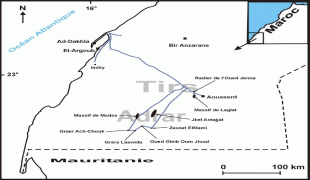
The region covers an area of 50,880 km2 and had a population of 142,955 according to the 2014 census. The capital is the coastal city of Dakhla, formerly known as Villa Cisneros.
The region comprises two provinces:
Dakhla-Oued Ed-Dahab consists of two provinces:
* Aousserd Province
* Oued Ed-Dahab Province
Map - Oued Ed-Dahab-Lagouira (Oued Ed-Dahab-Lagouira)
Map


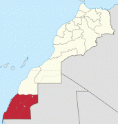
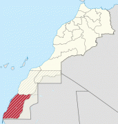
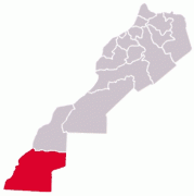
Country - Western_Sahara
|
Occupied by Spain until 1975, Western Sahara has been on the United Nations list of non-self-governing territories since 1963 after a Moroccan demand. It is the most populous territory on that list, and by far the largest in area. In 1965, the United Nations General Assembly adopted its first resolution on Western Sahara, asking Spain to decolonize the territory. One year later, a new resolution was passed by the General Assembly requesting that a referendum be held by Spain on self-determination. In 1975, Spain relinquished administrative control of the territory to a joint administration by Morocco, which had formally claimed the territory since 1957 and Mauritania. A war erupted between those countries and a Sahrawi nationalist movement, the Polisario Front, which proclaimed itself the rightful leadership of the SADR with a government in exile in Tindouf, Algeria. Mauritania withdrew its claims in 1979, and Morocco eventually secured de facto control of most of the territory, including all major cities and most natural resources. The United Nations considers the Polisario Front to be the legitimate representative of the Sahrawi people, and maintains that the Sahrawis have a right to self-determination.
Currency / Language
| ISO | Currency | Symbol | Significant figures |
|---|---|---|---|
| MAD | Moroccan dirham | د م. | 2 |
| ISO | Language |
|---|---|
| AR | Arabic language |