Nauru
 |
 |
| Flag of Nauru | |
Settled by people from Micronesia circa 1000 BCE, Nauru was annexed and claimed as a colony by the German Empire in the late 19th century. After World War I, Nauru became a League of Nations mandate administered by Australia, New Zealand, and the United Kingdom. During World War II, Nauru was occupied by Japanese troops, and was bypassed by the Allied advance across the Pacific. After the war ended, the country entered into United Nations trusteeship. Nauru gained its independence in 1968, and became a member of the Pacific Community (PC) in 1969.
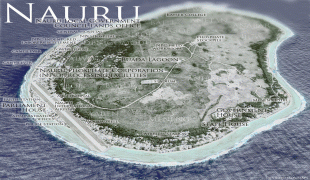
Nauru is a phosphate-rock island with rich deposits near the surface, which allowed easy strip mining operations for over a century. However, this has seriously harmed the country's environment, causing the island nation to suffer from what is often referred to as the "resource curse". The phosphate was exhausted in the 1990s, and the remaining reserves are not economically viable for extraction. A trust established to manage the island's accumulated mining wealth, set up for the day the reserves would be exhausted, has diminished in value. To earn income, Nauru briefly became a tax haven and illegal money laundering centre. At various points since 2001, it has accepted aid from the Australian Government in exchange for hosting the Nauru Regional Processing Centre, a controversial offshore Australian immigration detention facility. As a result of heavy dependence on Australia, some sources have identified Nauru as a client state of Australia. The sovereign state is a member of the United Nations, the Commonwealth of Nations, and the Organization of African, Caribbean, and Pacific States.
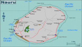
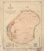
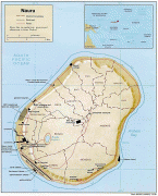
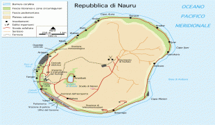
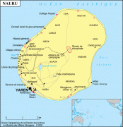
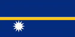
Nauru was first settled by Micronesians at least 3,000 years ago, and there is evidence of possible Polynesian influence. Comparatively little is known of Nauruan prehistory, although the island is believed to have had a long period of isolation, which accounts for the distinct language that developed among the inhabitants. There were traditionally 12 clans or tribes on Nauru, which are represented in the twelve-pointed star on the country's flag. Traditionally, Nauruans traced their descent matrilineally. Inhabitants practised aquaculture: they caught juvenile milkfish (known as ibija in Nauruan), acclimatised them to freshwater, and raised them in the Buada Lagoon, providing a reliable food source. The other locally grown components of their diet included coconuts and pandanus fruit. The name "Nauru" may derive from the Nauruan word Anáoero, which means 'I go to the beach.'
In 1798, the British sea captain John Fearn, on his trading ship Hunter (300 tons), became the first Westerner to report sighting Nauru, calling it "Pleasant Island", because of its attractive appearance. From at least 1826, Nauruans had regular contact with Europeans on whaling and trading ships who called for provisions and fresh drinking water. The last whaler to call during the age of sail visited in 1904.
Around this time, deserters from European ships began to live on the island. The islanders traded food for alcoholic palm wine and firearms. The firearms were used during the 10-year Nauruan Civil War that began in 1878.
After an agreement with Great Britain, Nauru was annexed by Germany in 1888 and incorporated into Germany's Marshall Islands Protectorate for administrative purposes. The arrival of the Germans ended the civil war, and kings were established as rulers of the island. The most widely known of these was King Auweyida. Christian missionaries from the Gilbert Islands arrived in 1888. The German settlers called the island "Nawodo" or "Onawero". The Germans ruled Nauru for almost three decades. Robert Rasch, a German trader who married a Nauruan woman, was the first administrator, appointed in 1890.
Phosphate was discovered on Nauru in 1900 by the prospector Albert Fuller Ellis. The Pacific Phosphate Company began to exploit the reserves in 1906 by agreement with Germany, exporting its first shipment in 1907. In 1914, following the outbreak of World War I, Nauru was captured by Australian troops. In 1919, it was agreed by the Allied and Associated Powers that His Britannic Majesty should be the administering authority under a League of Nations mandate. The Nauru Island Agreement forged in 1919 between the governments of the United Kingdom, Australia, and New Zealand provided for the administration of the island and extraction of the phosphate deposits by an intergovernmental British Phosphate Commission (BPC). The terms of the League of Nations mandate were drawn up in 1920.
The island experienced an influenza epidemic and ongoing colonial strife through the early 20th century, with a mortality rate of 18 per cent among native Nauruans. In 1923, the League of Nations gave Australia a trustee mandate over Nauru, with the United Kingdom and New Zealand as co-trustees. On 6 and 7 December 1940, the German auxiliary cruisers Komet and Orion sank five supply ships in the vicinity of Nauru. Komet then shelled Nauru's phosphate mining areas, oil storage depots, and the shiploading cantilever.
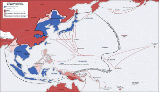
Japanese troops occupied Nauru on 25 August 1942. The Japanese built 2 airfields which were bombed for the first time on 25 March 1943, preventing food supplies from being flown to Nauru. The Japanese deported 1,200 Nauruans to work as labourers in the Chuuk Islands, which was also occupied by Japan. As part of the Allied strategy of island hopping from the Pacific islands towards the main islands of Japan, Nauru was bypassed and left to "wither on the vine". Nauru was finally liberated on 13 September 1945, when commander Hisayaki Soeda surrendered the island to the Australian Army and the Royal Australian Navy. The surrender was accepted by Brigadier J. R. Stevenson, who represented Lieutenant General Vernon Sturdee, the commander of the First Australian Army, aboard the warship HMAS Diamantina. Arrangements were made to repatriate from Chuuk the 745 Nauruans who survived Japanese captivity there. They were returned to Nauru by the BPC ship Trienza in January 1946.
Currency / Language
| ISO | Currency | Symbol | Significant figures |
|---|---|---|---|
| AUD | Australian dollar | $ | 2 |
| ISO | Language |
|---|---|
| EN | English language |
| NA | Nauru language |