Map - Mohéli

Mohéli
Mohéli, also known as Mwali, is an autonomous island that forms part of the Union of the Comoros. It is the smallest of the three major islands in the country. It is located in the Indian Ocean off the coast of Africa and it is the smallest of the four major Comoro Islands. Its capital and largest city is Fomboni.

Until 1830, Mohéli was part of the Ndzuwani Sultanate, which also controlled the neighbouring island of Anjouan. In 1830, migrants from Madagascar led by Ramanetaka, who later changed his name to Abderemane, took over the island and established the sultanate of Mwali. In the mid-nineteenth century its ruler was Queen Jumbe-Souli. In 1886, France made the island a protectorate.

Until 1889, Mwali had its own French resident, but the island was then subjugated to the residency of Anjouan. The sultanate was crushed in 1909 when the French annexed the island. French colonial stamps inscribed Mohéli were issued from 1906 to 1912.
 
Map - Mohéli
Map
Google - Map - Mohéli
Google
Google Earth - Map - Mohéli
Google Earth
Openstreetmap - Map - Mohéli
Openstreetmap
Map - Mohéli - Esri.WorldImagery
Esri.WorldImagery
Map - Mohéli - Esri.WorldStreetMap
Esri.WorldStreetMap
Map - Mohéli - OpenStreetMap.Mapnik
OpenStreetMap.Mapnik
Map - Mohéli - OpenStreetMap.HOT
OpenStreetMap.HOT
Map - Mohéli - OpenTopoMap
OpenTopoMap
Map - Mohéli - CartoDB.Positron
CartoDB.Positron
Map - Mohéli - CartoDB.Voyager
CartoDB.Voyager
Map - Mohéli - OpenMapSurfer.Roads
OpenMapSurfer.Roads
Map - Mohéli - Esri.WorldTopoMap
Esri.WorldTopoMap
Map - Mohéli - Stamen.TonerLite
Stamen.TonerLite
Country - Comoros
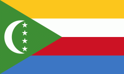
Flag of the Comoros
The Comoros, officially the Union of the Comoros, is an independent country made up of three islands in Southeastern Africa, located at the northern end of the Mozambique Channel in the Indian Ocean. Its capital and largest city is Moroni. The religion of the majority of the population, and the official state religion, is Sunni Islam. Comoros proclaimed its independence from France on 6 July 1975. A member of the Arab League, it is the only country in the Arab world which is entirely in the Southern Hemisphere. It is a member state of the African Union, the Organisation internationale de la Francophonie, the Organisation of Islamic Cooperation, and the Indian Ocean Commission. The country has three official languages: Shikomori, French and Arabic.

The sovereign state consists of three major islands and numerous smaller islands, all of the volcanic Comoro Islands with the exception of Mayotte. Mayotte voted against independence from France in a referendum in 1974, and continues to be administered by France as an overseas department. France has vetoed United Nations Security Council resolutions that would affirm Comorian sovereignty over the island. Mayotte became an overseas department and a region of France in 2011 following a referendum which was passed overwhelmingly.
Currency / Language  
ISO Currency Symbol Significant figures
KMF Comoro franc Fr 0
Neighbourhood - Country  
Administrative Subdivision
City, Village,...