Mayotte
 |
 |
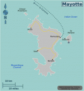
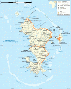
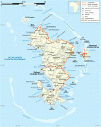
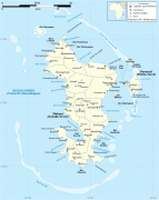
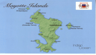
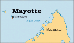
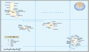
Mayotte's land area is 374 km2 and, with its 310,022 people according to January 2023 official estimates, is very densely populated at 829 inhabitants per km2 (2,073 per sq mi). The biggest city and prefecture is Mamoudzou on Grande-Terre. The Dzaoudzi–Pamandzi International Airport is located on the neighbouring island of Petite-Terre. The territory is also known as Maore, the native name of its main island.
Mayotte is one of the overseas departments of France as well as one of the 18 regions of France, with the same status as the departments of Metropolitan France. It is an outermost region of the European Union and, as an overseas department of France, part of the eurozone.
French is the official language and is spoken as a second language by an increasing part of the population, with 63% of the population 14 years and older reporting in the 2007 census that they could speak it. The native languages of Mayotte are Shimaore, which is the most spoken, and the lesser spoken Kibushi, a Malagasy language, of which there are two varieties, Kibushi sakalava, most closely related to the Sakalava dialect of Malagasy, and Kibushi antalaotsi, most closely related to the dialect spoken by the Antalaotra of Madagascar. Both have been influenced by Shimaore.
The island was populated from neighbouring East Africa with later arrival of Arabs, who brought Islam. A sultanate was established in 1500. The vast majority of the population today is Muslim. In the 19th century, Mayotte was conquered by Andriantsoly, former king of Iboina on Madagascar.
Mayotte chose to remain with France after the Comoros declared its independence following the 1974 referendum. Mayotte became an overseas department on 31 March 2011 and became an outermost region of the European Union on 1 January 2014, following a March 2009 referendum with an overwhelming result in favour of the department status.
The department faces enormous challenges. According to an INSEE report published in 2018, 84% of the population live under the poverty line (established at €959 per month and per household), compared to 16% in metropolitan France, 40% of dwellings are corrugated sheet metal shacks, 29% of households have no running water, and 34% of the inhabitants between the age of 15 and 64 do not have a job. In 2019, with an annual population growth of 3.8%, half the population was less than 17 years old. In addition, as a result of immigration from neighboring islands, 48% of the population were foreign nationals.
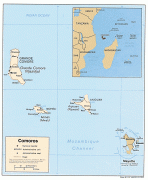
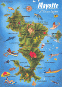
The term Mayotte (or Maore) may refer to all of the department's islands, of which the largest is known as Maore (Grande-Terre) and includes Maore's surrounding islands, most notably Pamanzi (Petite-Terre), or only to the largest island. The name is believed to come from Mawuti, contraction of the Arabic جزيرة الموت Jazīrat al-Mawt – meaning "island of death" (maybe due to the dangerous reefs circling the island) and corrupted to Mayotta in Portuguese, later turned into French. However, the local name is Mahore, and the Arabic etymology is doubtful.
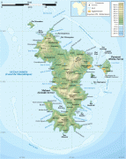
The main island, Grande-Terre (or Maore), geologically the oldest of the Comoro Islands, is 39 km long and 22 km wide, and its highest point is Mount Benara, at 660 m above sea level. Because of the volcanic rock, the soil is relatively rich in some areas. A coral reef encircling much of the island ensures protection for ships and a habitat for fish. Dzaoudzi was the capital of Mayotte (and earlier the capital of all the colonial Comoros) until 1977, when the capital was relocated to Mamoudzou on the main island of Grande-Terre. It is situated on Petite-Terre (or Pamanzi), which at 10 km2 is the largest of several islets adjacent to Maore. The area of the lagoon behind the reef is approximately 1500 sqkm, reaching a maximum depth of about 80m. It is described as "the largest barrier-reef-lagoon complex within the southwestern Indian Ocean".