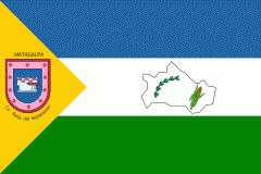
Matagalpa Department (Departamento de Matagalpa)
 |
 |
Matagalpa is the second largest region of the country in population size, and the fifth in area (after the North Atlantic, the South Atlantic, Jinotega and Río San Juan).
Matagalpa is the most diversified region producing coffee, cattle, milk products, vegetables, wood, gold, flowers. Its extensive forests, rivers and geography are suited for ecotourism.
* 1) Ciudad Darío
* 2) Esquipulas
* 3) Matagalpa
* 4) Matiguas
* 5) Muy Muy
* 6) Rancho Grande
* 7) Río Blanco
Map - Matagalpa Department (Departamento de Matagalpa)
Map


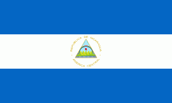
Country - Nicaragua
 |
 |
| Flag of Nicaragua | |
Originally inhabited by various indigenous cultures since ancient times, the region was conquered by the Spanish Empire in the 16th century. Nicaragua gained independence from Spain in 1821. The Mosquito Coast followed a different historical path, being colonized by the English in the 17th century and later coming under British rule. It became an autonomous territory of Nicaragua in 1860 and its northernmost part was transferred to Honduras in 1960. Since its independence, Nicaragua has undergone periods of political unrest, dictatorship, occupation and fiscal crisis, including the Nicaraguan Revolution of the 1960s and 1970s and the Contra War of the 1980s.
Currency / Language
| ISO | Currency | Symbol | Significant figures |
|---|---|---|---|
| NIO | Nicaraguan córdoba | C$ | 2 |
| ISO | Language |
|---|---|
| EN | English language |
| ES | Spanish language |
