Map - Halland (Halland County)

Halland (Halland County)
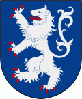
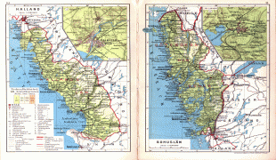
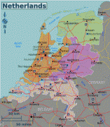
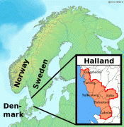
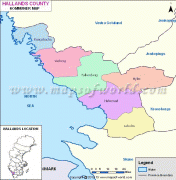
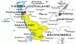
Halland is one of the traditional provinces of Sweden (landskap), on the western coast of Götaland, southern Sweden. It borders Västergötland, Småland, Scania and the sea of Kattegat. Until 1645 and the Second Treaty of Brömsebro, it was part of the Kingdom of Denmark. Its name means Land of Rocky Slabs (Swedish: hällar) referring to the coastal cliffs of the region.

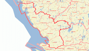
The provinces of Sweden serve no administrative function. Instead, that function is served by the Counties of Sweden. However, the province of Halland is almost coextensive with the administrative Halland County, though parts of the province belong to Västra Götaland County and Skåne County, while the county also includes parts of Småland and Västergötland.

As of 31 December 2016 Halland had a population of 327,093. Of these, 310,536 lived in Halland County; 14,205 lived in Västra Götaland County; and 2,352 lived in Skåne County.

 
Map - Halland (Halland County)
Map
Google - Map - Halland
Google
Google Earth - Map - Halland
Google Earth
Openstreetmap - Map - Halland
Openstreetmap
Cohrs_atlas_%C3%B6ve...
4125x3164
upload.wikimedia.org
Netherlands-regions-...
1928x2215
wikitravel.org
Holland.jpg
2000x1808
www.tourvideos.com
netherlands-map-of-c...
1236x1737
rememberingletters.f...
4335214662_39a80eac0...
1131x1695
farm3.staticflickr.c...
map-of-Netherlands-o...
1352x1051
4.bp.blogspot.com
road_map_of_netherla...
1036x1178
www.vidiani.com
denemark-including-h...
900x1200
www.mapandmaps.com
denemark-including-h...
900x1200
www.mapandmaps.com
holland-physical-lar...
794x898
www.europeetravel.co...
LA2-Halland.png
697x717
upload.wikimedia.org
map-level1-south-ken...
803x608
2012.afscme.org
Karta-%25C3%25B6ver-...
740x600
2.bp.blogspot.com
belgium_holland_map....
594x653
www.rgts.co.uk
49e8baa260e7626c3e2f...
600x612
media-cache-ak0.pini...
denemark-including-h...
600x600
www.mapandmaps.com
denemark-including-h...
600x600
www.mapandmaps.com
denemark-including-h...
600x600
www.mapandmaps.com
denemark-including-h...
600x600
www.mapandmaps.com
halland-map.gif
602x566
www.map-of-sweden.co...
Country - Sweden
Flag of Sweden
Sweden, formally the Kingdom of Sweden, is a Nordic country located on the Scandinavian Peninsula in Northern Europe. It borders Norway to the west and north, Finland to the east, and is connected to Denmark in the southwest by a bridge–tunnel across the Öresund. At 447425 km2, Sweden is the largest Nordic country, the third-largest country in the European Union, and the fifth-largest country in Europe. The capital and largest city is Stockholm. Sweden has a total population of 10.5 million, and a low population density of 25.5 PD/km2, with around 87% of Swedes residing in urban areas, which cover 1.5% of the entire land area, in the central and southern half of the country.

Nature in Sweden is dominated by forests and many lakes, including some of the largest in Europe. Many long rivers run from the Scandes range through the landscape, primarily emptying into the northern tributaries of the Baltic Sea. It has an extensive coastline and most of the population lives near a major body of water. With the country ranging from 55°N to 69°N, the climate of Sweden is diverse due to the length of the country. The usual conditions are mild for the latitudes with a maritime south, continental centre and subarctic north. Snow cover is infrequent in the densely populated south, but reliable in higher latitudes. Furthermore, the rain shadow of the Scandes results in quite dry winters and sunny summers in much of the country.
Currency / Language  
ISO Currency Symbol Significant figures
SEK Swedish krona kr 2
Neighbourhood - Country  
  •  Finland 
  •  Norway 
Administrative Subdivision
Country, State, Region,...
City, Village,...