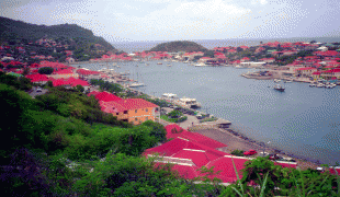
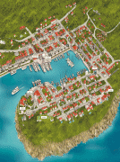
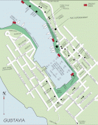
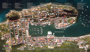
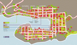
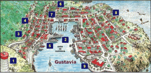
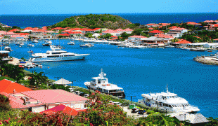
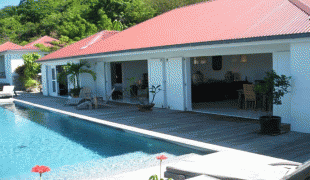
Map - Gustavia, Saint Barthélemy (Gustavia)

Gustavia (Gustavia)
Gustavia is the main town and capital of the island of Saint Barthélemy. Originally called Le Carénage, it was renamed in honor of King Gustav III of Sweden.

Saint Barthélemy was first claimed by France in 1648. The island was given to Sweden in exchange for trade rights in Gothenburg in 1784 and Sweden founded the Swedish West India Company. Prospering during the Napoleonic Wars, assets were low thereafter, and the island was sold back to France in 1878.

The eventual site of Gustavia was first called Le Carénage (The Careening) after the shelter it provided to damaged ships. According to the archives, the name Gustavia appeared between December 28, 1786, and February 9, 1787. Gustavia remains as a reflection of the Swedish period, during which a minority of the population of approximately 4% were of Swedish origin.

Three forts built in the mid- to late 17th century protected the harbour: Oscar (formerly Gustav Adolf), Karl and Gustav. The Saint-Bartholomew Anglican Church on the harbourfront was built in 1855.

Gustavia's sister city is Piteå, located in Norrbotten, Sweden.

 
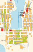
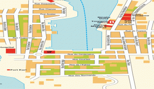
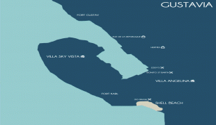
Map - Gustavia (Gustavia)
Map
Google Earth - Map - Gustavia, Saint Barthélemy
Google Earth
Openstreetmap - Map - Gustavia, Saint Barthélemy
Openstreetmap
60710d1390766282-my-...
1920x1080
www.cartographersgui...
Gustavia_San_Barth_0...
1544x1026
upload.wikimedia.org
Gustavia-Map.jpg
1000x1565
www.mappery.com
Stadtplan-Gustavia-7...
1565x1000
www.hot-map.com
St-Barthelemy-Map.gi...
1446x1064
www.mappery.com
gustavia-plan-gm.png
1042x1400
www.teledom.fr
7150474275_f5fe01e54...
1300x953
farm8.staticflickr.c...
GustaviaMap-971x1024...
1024x971
blog.handpickedvilla...
7150474275_9f08bde94...
751x1024
farm8.static.flickr....
karta-over-gustavia-...
731x935
www.travelforum.se
plan_de_gustavia_4_8...
802x568
www.comstbarth.fr
Gustavia%20Walking%2...
509x800
www.guidetocaribbean...
Gustavia-Hill-Gustav...
700x467
www.wheretostay.com
gustavia.jpg
700x459
www.saint-barths.com
plan-gustavia_1.jpg
800x386
www.comstbarth.fr
600070037_d011d04ba3...
640x480
farm2.staticflickr.c...
7150474275_9f08bde94...
640x469
farm8.staticflickr.c...
map_of_Gustavia_hexa...
720x360
www.discoverlife.org
map_of_Gustavia.jpg
360x720
www.discoverlife.org
1437909561da4597bb24...
600x400
static.paradizo.com
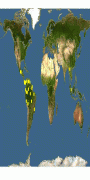
Country - Saint_Barthélemy
Saint Barthélemy (Saint-Barthélemy, ), officially the Collectivité territoriale de Saint-Barthélemy, also known as St. Barts (English) or St. Barth (French), is an overseas collectivity of France in the Caribbean. The island lies about 30 km southeast of the island of Saint Martin; it is northeast of the Dutch islands of Saba and Sint Eustatius, as well as north of the independent country of Saint Kitts and Nevis.

Saint Barthélemy was for many years a French commune forming part of Guadeloupe, which is an overseas region and department of France. In 2003 the island voted in favour of secession from Guadeloupe to form a separate overseas collectivity (collectivité d'outre-mer, abbreviated to COM) of France. The collectivity is one of four territories among the Leeward Islands in the northeastern Caribbean that make up the French West Indies, along with Saint Martin, Guadeloupe (200 km southeast), and Martinique.
Currency / Language  
ISO Currency Symbol Significant figures
EUR Euro € 2
ISO Language
FR French language
Neighbourhood - Country