Guanajuato (Estado de Guanajuato)
 |
 |
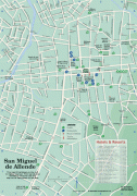
Guanajuato is in central Mexico. It is bordered by the states of Jalisco to the west, Zacatecas to the northwest, San Luis Potosí to the north, Querétaro to the east, and Michoacán to the south. It covers an area of 30,608 km2. The state is home to several historically important cities, especially those along the "Bicentennial Route", which retraces the path of Miguel Hidalgo y Costilla's insurgent army at the beginning of the Mexican War of Independence. This route begins at Dolores Hidalgo, and passes through the Sanctuary of Atotonilco, San Miguel de Allende, Celaya, and the capital of Guanajuato. Other important cities in the state include León, the state's biggest city, Salamanca, and Irapuato. The first town established by the Spaniards in Guanajuato is Acámbaro while the first to be named a city is Salvatierra.
Guanajuato is between the arid north of the country and the lusher south, and is geographically part of the Trans-Mexican Volcanic Belt, the Mexican Plateau. It was initially settled by the Spanish in the 1520s due to mineral deposits found around the city of Guanajuato, but areas such as the Bajío region also became important for agriculture and livestock. Mining and agriculture were the mainstays of the state's economy, but have since been eclipsed by the secondary sector. Guanajuato has particularly seen growth in the automotive industry. The name Guanajuato comes from Purépecha kuanhasï juáta (or in older orthography "quanax huato"), which means "frog hill".
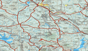
Guanajuato is in the center of Mexico, northwest of Mexico City, bordering Zacatecas, San Luis Potosí, Michoacán, Querétaro, and Jalisco. It is the 20th-largest of Mexico's states, with an area of 30,589 km². It has an average altitude of 2,015 m above sea level, with its territory divided among three of Mexico's physical regions, the Sierra Madre Oriental, the Mexican Plateau and the Trans-Mexican Volcanic Belt. The Sierra Madre Oriental in Guanajuato consists of the Sierra Gorda and the Sierra del Azafrán in the northeast. The Mexican Plateau extends through the center of the state. It is subdivided into various regions parted by low-lying mountain chains such as the Sierra de la Cuatralba and the Sierra de Cubo. The Trans Mexican Volcanic Belt crosses the state in the south and includes the Bajío area, the Altos de Jalisco and the valleys area in the far south. The state is crossed by several mountain ranges with mountains between 2,300 and 3,000 meters high. Mountain ranges average 2,305 meters and flat areas lie at around 1,725 meters above mean sea level. Other important mountain ranges include the Sierra Gorda to the north, the Sierra de Guanajuato in the southeast, the Comanja in the northwest and the Codorniz in the east. The state is divided into five regions, taking into consideration geography and climate: Altos de Guanajuato, La Sierra Central, Bajío, La Sierra Gorda, and Los Valles del Sur. The Altos de Guanajuato, in the north, are a chain of forested mountains interspersed with pastures, small fields and areas with cacti and other desert plants. They begin near the border with San Luis Potosí, and extend south to Dolores Hidalgo, San Miguel de Allende, and the Querétaro border. This area's altitude varies from 1,800 meters to peaks over 2,900, such as La Giganta and La Sierra del Cubo. The climate is mostly semiarid with a rainy season in the summer, with average temperatures between 15 and 20 °C. Winter lows often reach 0 °C or lower with frosts. Wildlife is found mostly in the most rugged and inaccessible areas and includes deer, coyotes, eagles and rattlesnakes. La Sierra Gorda is shared between Guanajuato and Querétaro and is considered an important biosphere. This area is the most rugged in the state where most of the natural areas and small villages remain intact due to their inaccessibility. The Sierra Gorda is part of the Sierra Madre Occidental, with extreme variations in its geography and climate. The rugged terrain means that there are a wide number and variety of micro-climates, although average temperatures vary only between 16 and 19 °C. It lowest point is a canyon called Paso de Hormigas in Xichú at 650 meters above sea level with a very warm climate suitable for tropical fruit. The highest point is Pinal de Zamorano at 3,300 meters, followed by El Picacho de Pueblo Nuevo, El Zorillo and El Cuervo, all above 2,700 meters. The largest changes are seen in arid versus wetter zones, which can often be relatively nearby, with foliage changing from rainforest to pine forest to desert landscapes. In 1997, the federal government declared the Sierra Gorda region in Querétaro a Biosphere Reserve, with Guanajuato's portion added in 2007. On the Guanajuato side, it covers 236,882 hectares over the municipalities of Xichú, San Luis de la Paz, Atarjea, Victoria and Santa Catarina. Culturally, the Sierra Gorda region is the far western part of La Huasteca, which extends over parts of Querétaro, San Luis Potosí, Hidalgo and Veracruz.
The Sierra Central is a series of low, gentle mountains in the center of the state that are part of the Sierra Madre Occidental. They cover 12 municipalities: Ocampo, San Felipe, León, Silao, Guanajuato, Dolores Hidalgo, San Miguel de Allende, Irapuato, Salamanca, Santa Cruz de Juventino Rosas, Comonfort and Apaseo el Grande. Wild vegetation runs from tropical rainforest to arid grasslands with cactus, with cypress trees along rivers and other surface water. Wildlife includes raccoons, quail, rabbits, skunks and migratory birds. The land is productive, especially for fruit orchards producing guavas, tejocote, apples, limes, quince and more. Desert fruits such as cactus pears (tuna), garambullos and xoconostle are also produced commercially.
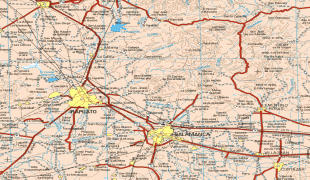
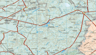
The state's best-known geographical region is the Bajío, a relatively low and flat area of between 1,700 and 1,800 meters that surrounds the Lerma River and its tributaries. Centered in Guanajuato, parts also extend into Querétaro and Jalisco. This low area is the source of its name, coming from the Spanish word "bajo" or low. The Bajío is filled with rolling hills and interrupted by the occasional chain of low mountains such as the Gavia and the Culiacán. Before the Spanish arrived, this area was covered in dense forests of holm oak and mesquite trees, but mining's need for wood fuel eventually cleared them. Today, the area is the center of most of the state's agriculture and industry since the terrain allows for highways and large farms, which produce grains, vegetables and fruit. This farmland is considered some of Mexico's most productive. Los Valles del Sur, also called the Valles Abajeños, are valleys located in southwestern Guanajuato, bordering Michoacán. This area is distinguished by the large number of Purépecha place names and covers the municipalities of Valle de Santiago, Yuriria, Tarimoro, Apaseo el Alto, Moroleón, Uriangato, Santiago Maravatío, Acámbaro, Jerécuaro, Coroneo and Tarandacuao. The area is part of the Trans-Mexican Volcanic Belt, with elevations ranging between 1,700 and 2,000 meters. The soil is fertile due to its volcanic base, producing crops such as sorghum, wheat, corn and vegetables. The land also produces building materials such as tezontle and black sandstone. In the higher elevations, there are forests of pine and holm oak but these have been much reduced by deforestation. The more arid areas have mesquite, nopal and other desert plants. There are several small lakes, the best known being Lake Yuriria as well as canyons and cave systems, some of which were used for ceremonial purposes by pre-Hispanic peoples. It is also the home the Siete Luminarias de Valle de Santiago, a set of seven inactive volcanic craters in the northwest and southwest of the Santiago Valley. The volcano cones rise abruptly out of the ground with craters up to one kilometer across. Locals call the formations "holes" (hoyos) and they are named La Alberca, La Cíntora, Estrada, Blanca, Alvarez, Solís and Rincón de Parangueo. La Cíntora and Rincón de Parangueo contain cave paintings and evidence that people once lived in the craters. La Alberca ("The Pool") is a crater lake open to the public for swimming, rowing or boating. The name of Siete Luminarias ("Seven Lanterns") comes from an imagined prehistoric time when the seven were active at once.
The state has about 1,500 bodies of surface water, along with underground aquifers in most parts of the state. Its principal lake is Lake Cuitzeo, on the border with Michoacán and the Yuriria. Several of the Siete Luminarias craters have also developed crater lakes, especially La Joya, Parangueo and Olla de Zìntora. The most important river in Guanjuato and one of the most important in the country is the Lerma, along with its tributaries Guanajuato River, La Laja, and Turbio. The Lerma river basin covers 81% of the state (center and south); the Pánuco River basin (north of the state) and Cuitzeo Lake cover the remainder. The Lerma is regulated by various dams in part to control the fact that it ran very high in the rainy season and very low in the dry season. These dams include the Ignacio Allende, la Purísima, Solís, La Gavia, Conejo II and Santa Ifigenia.
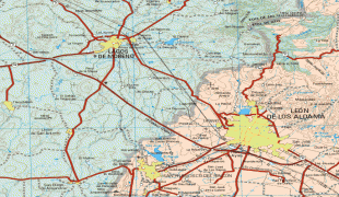
Map - Guanajuato (Estado de Guanajuato)
Map


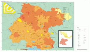

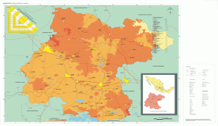


Country - Mexico


Currency / Language
| ISO | Currency | Symbol | Significant figures |
|---|---|---|---|
| MXV | Mexican Unidad de Inversion | 2 | |
| MXN | Mexican peso | $ | 2 |
| ISO | Language |
|---|---|
| ES | Spanish language |