Gaborone
Gaborone is the capital and largest city of Botswana with a population of 246,325 based on the 2022 census, about 10% of the total population of Botswana. Its agglomeration is home to 421,907 inhabitants at the 2011 census.
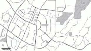
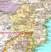
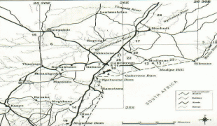
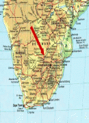
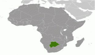
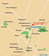
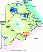
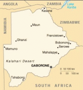
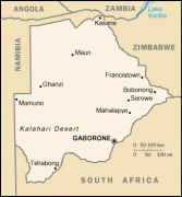
Gaborone is situated between Kgale Hill and Oodi Hill, near the confluence of the Notwane River and Segoditshane River in the south-eastern corner of Botswana, 15 km from the South African border. The city is served by the Sir Seretse Khama International Airport. It is an administrative district in its own right, but is the capital of the surrounding South-East District. Locals often refer to the city as GC or Motse-Mshate.
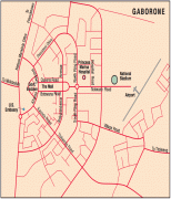
The city of Gaborone is named after Chief Gaborone of the Tlokwa tribe, who once controlled land nearby. Because it had no tribal affiliation and was close to fresh water, the city was planned to be the capital in the mid-1960s when the Bechuanaland Protectorate became an independent nation. The centre of the city is a long strip of commercial businesses, called "Main Mall" with a semicircle-shaped area of government offices to its east. Gaborone was once one of the fastest-growing cities in the world, and this has created problems with housing and illegal settlements. The city has also dealt with conflicts spilling into the country from Zimbabwe and South Africa during the 1980s.
Gaborone is the economic capital as well as the government capital; it is headquarters to numerous companies and the Botswana Stock Exchange. Gaborone is also home to the Southern African Development Community (SADC), a regional economic community established in 1980. Many languages are spoken there, Setswana (Tswana) being the main tongue. English, Kalanga, and Kgalagadi are also spoken.
Evidence shows that there have been inhabitants along the Notwane River for centuries. In more recent history, the Tlokwa left the Magaliesberg ranges to settle in the area around 1880, and called the settlement Moshaweng. The word "Gaborone" literally means "it does not fit badly" or "it is not unbecoming". The city was then called "Gaberones" by early European colonizers. Gaberones, a shortening of "Gaborone's Village", was named after Chief Gaborone of the Tlokwa, whose home village (now called Tlokweng) was across the river from the Government Camp, the name of the colonial government headquarters. The nickname, "GC", comes from the name "Government Camp". In 1890, Cecil John Rhodes picked Gaberones to house a colonial fort. The fort was where Rhodes planned the Jameson Raid. The city changed its name from Gaberones to Gaborone in 1969.
The modern town was only founded in 1964, after a decision was taken to establish a capital for Botswana, which became a self governing territory in 1965, before becoming a fully independent republic on 30 September 1966.
In 1965, the capital of the Bechuanaland Protectorate moved from Mafeking to Gaberones. When Botswana gained its independence, Lobatse was the first choice as the nation's capital. However, Lobatse was deemed too limited, and instead, a new capital city would be created next to Gaberones. The city was chosen because of its proximity to a fresh water source, its proximity to the railway to Pretoria, its central location among the central tribes, and its lack of association with those surrounding tribes.
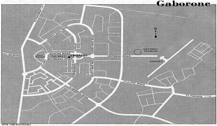
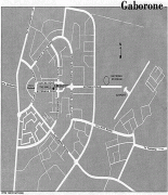
The city was planned under Garden city principles with numerous pedestrian walkways and open spaces. Building of Gaborone started in mid-1964. During the city's construction, the chairman of Gaberones Township Authority, Geoffrey Cornish, likened the layout of the city to a "brandy glass" with the government offices in the base of the glass and businesses in the "mall", a strip of land extending from the base.
Most of the early town was built within three years, as a small town designed to accommodate 20,000 people – only to later develop after independence into a modern city. Buildings in early Gaborone include assembly buildings, government offices, a power station, a hospital, schools, a radio station, a telephone exchange, police stations, a post office, and more than 1,000 houses. Because the town was built so quickly, there was a massive influx of labourers who had built illegal settlements on the new city's southern industrial development zone. These settlements were named Naledi. The latter term literally means "the star", but could also mean "under the open sky" or "a community that stands out from all others". In 1971, because of the growth of illegal settlements, the Gaborone Town Council and the Ministry of Local Government and Lands surveyed an area called Bontleng, which would contain low-income housing. However, Naledi still grew, and the demand for housing was greater than ever. In 1973, the Botswana Housing Corporation (BHC) built a "New Naledi" across the road from the "Old Naledi". Residents from Old Naledi would be moved to New Naledi. However, the demand for housing increased yet again; moreover, the residents who relocated to New Naledi disliked the houses. The problem was solved in 1975 when Sir Seretse Khama, the president of Botswana, rezoned Naledi from an industrial zone to a low-income housing area.
On 30 September 1966, Bechuanaland became the eleventh British dependency in Africa to become independent. The first mayor of Gaborone was Reverend Derek Jones. The old Gaberones became a suburb of the new Gaborone, and is now known as "the Village".
Gaborone is situated between Kgale Hill and Oodi Hill, near the confluence of the Notwane River and Segoditshane River in the south-eastern corner of Botswana, 15 km from the South African border. The city is served by the Sir Seretse Khama International Airport. It is an administrative district in its own right, but is the capital of the surrounding South-East District. Locals often refer to the city as GC or Motse-Mshate.
The city of Gaborone is named after Chief Gaborone of the Tlokwa tribe, who once controlled land nearby. Because it had no tribal affiliation and was close to fresh water, the city was planned to be the capital in the mid-1960s when the Bechuanaland Protectorate became an independent nation. The centre of the city is a long strip of commercial businesses, called "Main Mall" with a semicircle-shaped area of government offices to its east. Gaborone was once one of the fastest-growing cities in the world, and this has created problems with housing and illegal settlements. The city has also dealt with conflicts spilling into the country from Zimbabwe and South Africa during the 1980s.
Gaborone is the economic capital as well as the government capital; it is headquarters to numerous companies and the Botswana Stock Exchange. Gaborone is also home to the Southern African Development Community (SADC), a regional economic community established in 1980. Many languages are spoken there, Setswana (Tswana) being the main tongue. English, Kalanga, and Kgalagadi are also spoken.
Evidence shows that there have been inhabitants along the Notwane River for centuries. In more recent history, the Tlokwa left the Magaliesberg ranges to settle in the area around 1880, and called the settlement Moshaweng. The word "Gaborone" literally means "it does not fit badly" or "it is not unbecoming". The city was then called "Gaberones" by early European colonizers. Gaberones, a shortening of "Gaborone's Village", was named after Chief Gaborone of the Tlokwa, whose home village (now called Tlokweng) was across the river from the Government Camp, the name of the colonial government headquarters. The nickname, "GC", comes from the name "Government Camp". In 1890, Cecil John Rhodes picked Gaberones to house a colonial fort. The fort was where Rhodes planned the Jameson Raid. The city changed its name from Gaberones to Gaborone in 1969.
The modern town was only founded in 1964, after a decision was taken to establish a capital for Botswana, which became a self governing territory in 1965, before becoming a fully independent republic on 30 September 1966.
In 1965, the capital of the Bechuanaland Protectorate moved from Mafeking to Gaberones. When Botswana gained its independence, Lobatse was the first choice as the nation's capital. However, Lobatse was deemed too limited, and instead, a new capital city would be created next to Gaberones. The city was chosen because of its proximity to a fresh water source, its proximity to the railway to Pretoria, its central location among the central tribes, and its lack of association with those surrounding tribes.
The city was planned under Garden city principles with numerous pedestrian walkways and open spaces. Building of Gaborone started in mid-1964. During the city's construction, the chairman of Gaberones Township Authority, Geoffrey Cornish, likened the layout of the city to a "brandy glass" with the government offices in the base of the glass and businesses in the "mall", a strip of land extending from the base.
Most of the early town was built within three years, as a small town designed to accommodate 20,000 people – only to later develop after independence into a modern city. Buildings in early Gaborone include assembly buildings, government offices, a power station, a hospital, schools, a radio station, a telephone exchange, police stations, a post office, and more than 1,000 houses. Because the town was built so quickly, there was a massive influx of labourers who had built illegal settlements on the new city's southern industrial development zone. These settlements were named Naledi. The latter term literally means "the star", but could also mean "under the open sky" or "a community that stands out from all others". In 1971, because of the growth of illegal settlements, the Gaborone Town Council and the Ministry of Local Government and Lands surveyed an area called Bontleng, which would contain low-income housing. However, Naledi still grew, and the demand for housing was greater than ever. In 1973, the Botswana Housing Corporation (BHC) built a "New Naledi" across the road from the "Old Naledi". Residents from Old Naledi would be moved to New Naledi. However, the demand for housing increased yet again; moreover, the residents who relocated to New Naledi disliked the houses. The problem was solved in 1975 when Sir Seretse Khama, the president of Botswana, rezoned Naledi from an industrial zone to a low-income housing area.
On 30 September 1966, Bechuanaland became the eleventh British dependency in Africa to become independent. The first mayor of Gaborone was Reverend Derek Jones. The old Gaberones became a suburb of the new Gaborone, and is now known as "the Village".
Map - Gaborone
Map


Country - Botswana
 |
|
| Flag of Botswana | |
A country of slightly over 2.3 million people, Botswana is one of the most sparsely populated countries in the world. About 11.6 percent of the population lives in the capital and largest city, Gaborone. Formerly one of the world's poorest countries—with a GDP per capita of about US$70 per year in the late 1960s—it has since transformed itself into an upper-middle-income country, with one of the world's fastest-growing economies.
Currency / Language
| ISO | Currency | Symbol | Significant figures |
|---|---|---|---|
| BWP | Botswana pula | P | 2 |
| ISO | Language |
|---|---|
| EN | English language |
| TN | Tswana language |