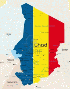
Chad (Republic of Chad)
 |
 |
| Flag of Chad | |
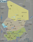
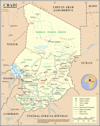
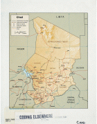
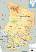
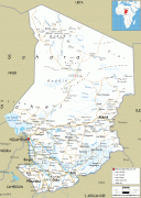
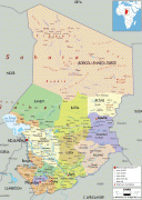
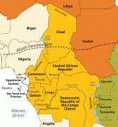
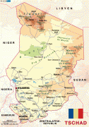
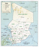
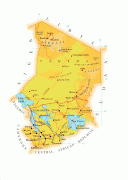
Chad has several regions: a desert zone in the north, an arid Sahelian belt in the centre and a more fertile Sudanian Savanna zone in the south. Lake Chad, after which the country is named, is the second-largest wetland in Africa. Chad's official languages are Arabic and French. It is home to over 200 different ethnic and linguistic groups. Islam (55.1%) and Christianity (41.1%) are the main religions practiced in Chad.
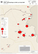
Beginning in the 7th millennium BC, human populations moved into the Chadian basin in great numbers. By the end of the 1st millennium AD, a series of states and empires had risen and fallen in Chad's Sahelian strip, each focused on controlling the trans-Saharan trade routes that passed through the region. France conquered the territory by 1920 and incorporated it as part of French Equatorial Africa. In 1960, Chad obtained independence under the leadership of François Tombalbaye. Resentment towards his policies in the Muslim north culminated in the eruption of a long-lasting civil war in 1965. In 1979 the rebels conquered the capital and put an end to the South's hegemony. The rebel commanders then fought amongst themselves until Hissène Habré defeated his rivals. The Chadian–Libyan conflict erupted in 1978 by the Libyan invasion which stopped in 1987 with a French military intervention (Operation Épervier). Hissène Habré was overthrown in turn in 1990 by his general Idriss Déby. With French support, a modernization of the Chad National Army was initiated in 1991. From 2003, the Darfur crisis in Sudan spilt over the border and destabilised the nation. Already poor, the nation and people struggled to accommodate the hundreds of thousands of Sudanese refugees who live in and around camps in eastern Chad.
While many political parties participated in Chad's legislature, the National Assembly, power laid firmly in the hands of the Patriotic Salvation Movement during the presidency of Idriss Déby, whose rule was described as authoritarian. After President Déby was killed by FACT rebels in April 2021, the Transitional Military Council led by his son Mahamat Déby assumed control of the government and dissolved the Assembly. Chad remains plagued by political violence and recurrent attempted coups d'état.
Chad ranks the 2nd lowest in the Human Development Index, with 0.394 in 2021 placed 190th, and a least developed country facing the effects of being one of the poorest and most corrupt countries in the world. Most of its inhabitants live in poverty as subsistence herders and farmers. Since 2003 crude oil has become the country's primary source of export earnings, superseding the traditional cotton industry. Chad has a poor human rights record, with frequent abuses such as arbitrary imprisonment, extrajudicial killings, and limits on civil liberties by both security forces and armed militias.
In the 7th millennium BC, ecological conditions in the northern half of Chadian territory favored human settlement, and its population increased considerably. Some of the most important African archaeological sites are found in Chad, mainly in the Borkou-Ennedi-Tibesti Region; some date to earlier than 2000 BC.
For more than 2,000 years, the Chadian Basin has been inhabited by agricultural and sedentary people. The region became a crossroads of civilizations. The earliest of these was the legendary Sao, known from artifacts and oral histories. The Sao fell to the Kanem Empire, the first and longest-lasting of the empires that developed in Chad's Sahelian strip by the end of the 1st millennium AD. Two other states in the region, Sultanate of Bagirmi and Wadai Empire, emerged in the 16th and 17th centuries. The power of Kanem and its successors was based on control of the trans-Saharan trade routes that passed through the region. These states, at least tacitly Muslim, never extended their control to the southern grasslands except to raid for slaves. In Kanem, about a third of the population were slaves.
French colonial expansion led to the creation of the Territoire Militaire des Pays et Protectorats du Tchad in 1900. By 1920, France had secured full control of the colony and incorporated it as part of French Equatorial Africa. French rule in Chad was characterised by an absence of policies to unify the territory and sluggish modernisation compared to other French colonies.
The French primarily viewed the colony as an unimportant source of untrained labour and raw cotton; France introduced large-scale cotton production in 1929. The colonial administration in Chad was critically understaffed and had to rely on the dregs of the French civil service. Only the Sara of the south was governed effectively; French presence in the Islamic north and east was nominal. The educational system was affected by this neglect.
After World War II, France granted Chad the status of overseas territory and its inhabitants the right to elect representatives to the National Assembly and a Chadian assembly. The largest political party was the Chadian Progressive Party (Parti Progressiste Tchadien, PPT), based in the southern half of the colony. Chad was granted independence on 11 August 1960 with the PPT's leader, François Tombalbaye, an ethnic Sara, as its first president.
Currency / Language
| ISO | Currency | Symbol | Significant figures |
|---|---|---|---|
| XAF | Central African CFA franc | Fr | 0 |
| ISO | Language |
|---|---|
| AR | Arabic language |
| FR | French language |