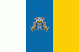
Canary Islands (Canary Islands)
 |
 |
The seven main islands are (from largest to smallest in area) Tenerife, Fuerteventura, Gran Canaria, Lanzarote, La Palma, La Gomera, and El Hierro. The archipelago includes many smaller islands and islets, including La Graciosa, Alegranza, Isla de Lobos, Montaña Clara, Roque del Oeste, and Roque del Este. It also includes a number of rocks, including Garachico and Anaga. In ancient times, the island chain was often referred to as "the Fortunate Isles". The Canary Islands are the southernmost region of Spain, and the largest and most populous archipelago of Macaronesia. Because of their location, the Canary Islands have historically been considered a link between the four continents of Africa, North America, South America, and Europe.
In 2019, the Canary Islands had a population of 2,153,389, with a density of 287.39 inhabitants per km2, making it the eighth most populous autonomous community of Spain. The population is mostly concentrated in the two capital islands: around 43% on the island of Tenerife and 40% on the island of Gran Canaria.
The Canary Islands, especially Tenerife, Gran Canaria, Fuerteventura, and Lanzarote, are a major tourist destination, with over 12 million visitors per year. This is due to their beaches, subtropical climate, and important natural attractions, especially Maspalomas in Gran Canaria and Mount Teide (a World Heritage Site) in Tenerife. Mount Teide is the highest peak in Spain and the third tallest volcano in the world, measured from its base on the ocean floor. The islands have warm summers and winters warm enough for the climate to be technically tropical at sea level. The amount of precipitation and the level of maritime moderation vary depending on location and elevation. The archipelago includes green areas as well as desert. The islands' high mountains are ideal for astronomical observation, because they lie above the temperature inversion layer. As a result, the archipelago boasts two professional observatories: Teide Observatory on Tenerife, and Roque de los Muchachos Observatory on La Palma.
In 1927, the Province of Canary Islands was split into two provinces. In 1982, the autonomous community of the Canary Islands was established. The cities of Santa Cruz de Tenerife and Las Palmas de Gran Canaria are, jointly, the capital of the islands. Those cities are also, respectively, the capitals of the provinces of Santa Cruz de Tenerife and Las Palmas. Las Palmas de Gran Canaria has been the largest city in the Canaries since 1768, except for a brief period in the 1910s. Between the 1833 territorial division of Spain and 1927, Santa Cruz de Tenerife was the sole capital of the Canary Islands. In 1927, it was ordered by decree that the capital of the Canary Islands would be shared between two cities, and this arrangement persists to the present day. The third largest city in the Canary Islands is San Cristóbal de La Laguna (another World Heritage Site) on Tenerife.
During the Age of Sail, the islands were the main stopover for Spanish galleons during the Spanish colonisation of the Americas, which sailed that far south in order to catch the prevailing northeasterly trade winds.
The name Islas Canarias is likely derived from the Latin name Canariae Insulae, meaning "Islands of the Dogs", a name that was evidently generalized from the ancient name of one of these islands, Canaria – presumably Gran Canaria. According to the historian Pliny the Elder, the island Canaria contained "vast multitudes of dogs of very large size".
Other theories speculate that the name comes from the Nukkari Berber tribe living in the Moroccan Atlas, named in Roman sources as Canarii, though Pliny again mentions the relation of this term with dogs. The connection to dogs is retained in their depiction on the islands' coat-of-arms. It is thought that the aborigines of Gran Canaria called themselves "Canarios". It is possible that after being conquered, this name was used in plural in Spanish, i.e., as to refer to all of the islands as the Canarii-as.
The name of the islands is not derived from the canary bird; rather, the birds are named after the islands.
Map - Canary Islands (Canary Islands)
Map
Country - Spain
 |
 |
| Flag of Spain | |
Anatomically modern humans first arrived in the Iberian Peninsula around 42,000 years ago. The ancient Iberian and Celtic tribes, along with other pre-Roman peoples, dwelled the territory maintaining contacts with foreign Mediterranean cultures. The Roman conquest and colonization of the peninsula (Hispania) ensued, bringing the Romanization of the population. Receding of Western Roman imperial authority ushered in the migration of different non-Roman peoples from Central and Northern Europe with the Visigoths as the dominant power in the peninsula by the fifth century. In the early eighth century, most of the peninsula was conquered by the Umayyad Caliphate, and during early Islamic rule, Al-Andalus became a dominant peninsular power centered in Córdoba. Several Christian kingdoms emerged in Northern Iberia, chief among them León, Castile, Aragon, Portugal, and Navarre made an intermittent southward military expansion, known as Reconquista, repelling the Islamic rule in Iberia, which culminated with the Christian seizure of the Emirate of Granada in 1492. Jews and Muslims were forced to choose between conversion to Catholicism or expulsion, and eventually the converts were expelled through different royal decrees.
Currency / Language
| ISO | Currency | Symbol | Significant figures |
|---|---|---|---|
| EUR | Euro | € | 2 |
| ISO | Language |
|---|---|
| EU | Basque language |
| CA | Catalan language |
| GL | Galician language |
| OC | Occitan language |
| ES | Spanish language |


