Map - Asmara

Asmara
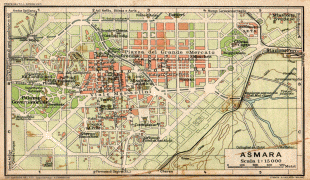
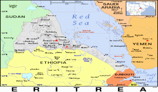
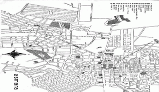
Asmara, or Asmera, is the capital and most populous city of Eritrea, in the country's Central Region. It sits at an elevation of 2325 m, making it the sixth highest capital in the world by altitude and the second highest capital in Africa. The city is located at the tip of an escarpment that is both the northwestern edge of the Eritrean Highlands and the Great Rift Valley in neighbouring Ethiopia. In 2017, the city was declared as a UNESCO World Heritage Site for its well-preserved modernist architecture. The site of Asmera was first settled in 800 BC with a population ranging from 100 to 1,000. The city was then founded in the 12th century AD after four separate villages unified to live together peacefully after long periods of conflict. Under Italian rule the city of Asmara was made capital of Eritrea in the last years of the 19th century.

Giving the Pre-Axumite archaeological evidence found in Asmara around Sembel Called the Ona culture, Asmara's history go back to 800 BCE and according to Eritrean Tigrinya oral traditional history, there were four clans living in the Asmera area on the Kebessa Plateau: the Gheza Gurtom, the Gheza Shelele, the Gheza Serenser and Gheza Asmae. These villages were frequently attacked by clans from the low land and from the rulers of "seger mereb melash" (which now is a Tigray region in Ethiopia), until the women of each clan decided that to defeat their common enemy and preserve peace the four clans must unite. The men accepted, hence the name "Arbate Asmera". Arbate Asmera literally means, in the Tigrinya language, "the four (feminine plural) made them unite". Eventually Arbate was dropped and it has been called Asmera which means "they [feminine, thus referring to the women] made them unite". There is still a district called Arbaete Asmara in the Administrations of Asmara. It is now called the Italianized version of the word Asmara. The westernized version of the name is used by a majority of non-Eritreans, while the multilingual inhabitants of Eritrea and neighboring peoples remain loyal to the original pronunciation, Asmera.

The missionary Remedius Prutky passed through Asmara in 1751, and described in his memoirs that a church built there by Jesuit priests 130 years before was still intact.

 
Map - Asmara
Map
Google - Map - Asmara
Google
Google Earth - Map - Asmara
Google Earth
Nokia - Map - Asmara
Nokia
Openstreetmap - Map - Asmara
Openstreetmap
txu-pclmaps-oclc-658...
6654x5491
www.lib.utexas.edu
txu-oclc-6654394-nd-...
5000x3980
www.lib.utexas.edu
yellowstone_1917.jpg
1761x1533
www.lib.utexas.edu
planimetria_asmara_1...
1793x1195
digilander.libero.it
Asmara---Massawa-Are...
1780x1013
www.zonu.com
massawa_tpc88.jpg
1780x1013
www.lib.utexas.edu
Eritrean%252Bterrito...
1120x1600
3.bp.blogspot.com
IAF-EAfrica-54.jpg
1200x1156
ibiblio.org
IAF-EAfrica-54.jpg
1200x1156
www.ibiblio.org
Eritrea.jpg
1197x895
4.bp.blogspot.com
map.jpg
895x1197
www.trainweb.org
Isayas%252BAfewerki%...
1196x868
1.bp.blogspot.com
IAF-EAfrica-57.jpg
1200x790
www.ibiblio.org
8695791357_c10cdf32f...
1024x768
farm9.staticflickr.c...
asmara-map.jpg
800x972
www.mapsofworld.com
er_blu.gif
810x790
ian.macky.net
pic-map-kag.jpg
794x611
www.asalives.org
boraasmaramap.jpg
800x566
i120.photobucket.com
BORA.jpg
720x576
2.bp.blogspot.com
asmara+21+map.jpg
640x592
4.bp.blogspot.com
Country - Eritrea
Flag of Eritrea
Eritrea, officially the State of Eritrea, is a country in the Horn of Africa region of Eastern Africa, with its capital and largest city at Asmara. It is bordered by Ethiopia in the south, Sudan in the west, and Djibouti in the southeast. The northeastern and eastern parts of Eritrea have an extensive coastline along the Red Sea. The nation has a total area of approximately 117600 km2, and includes the Dahlak Archipelago and several of the Hanish Islands.

Human remains found in Eritrea have been dated to 1 million years old and anthropological research indicates that the area may contain significant records related to the evolution of humans. Contemporary Eritrea is a multi-ethnic country with nine recognised ethnic groups. Nine different languages are spoken by the nine recognised ethnic groups, the most widely spoken language being Tigrinya, the others being Tigre, Saho, Kunama, Nara, Afar, Beja, Bilen and Arabic. Tigrinya, Arabic, and English serve as the three working languages. Most residents speak languages from the Afroasiatic family, either of the Ethiopian Semitic languages or Cushitic branches. Among these communities, the Tigrinyas make up about 55% of the population, with the Tigre people constituting around 30% of inhabitants. In addition, there are several Nilo-Saharan-speaking Nilotic ethnic groups. Most people in the country adhere to Christianity or Islam, with a small minority adhering to traditional faiths.
Currency / Language  
ISO Currency Symbol Significant figures
ERN Eritrean nakfa Nfk 2
Neighbourhood - Country  
  •  Djibouti 
  •  Ethiopia 
  •  Sudan