Akele Guzai (Earth)
The Provinces of Eritrea existed between Eritrea's incorporation as a colony of Italy until the conversion of the provinces into administrative regions.
In Italian Eritrea, the Italian colonial administration had divided the colony into eight provinces (administrative regions) called Akele Guzay, Barka, Denkalia, Hamasien, Sahel, Semhar, Senhit and Serae. These administrative regions relied heavily upon the historical political boundaries in the region, including, but not exclusively, that of local nobility. These Provinces of Eritrea were also used by the Federated Eritrean Government from 1952-1962 and as districts (awrajja) in Eritrea when it was annexed by Ethiopia from 1962-1991.
After independence, the Provisional Government of Eritrea converted the original eight Provinces of Eritrea (from the Italian colonial period) to nine provinces by splitting the Barka province in two (the north known as Barka Province and the south as Gash-Setit Province), while at the same time separating Asmara from the rest of Hamasien. On April 15, 1996, the Government of Eritrea converted the then nine Provinces of Eritrea into six administrative regions.
Map - Akele Guzai (Earth)
Map
Country - Eritrea
 |
 |
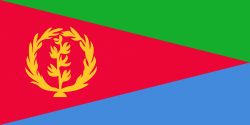
| Flag of Eritrea | |
Human remains found in Eritrea have been dated to 1 million years old and anthropological research indicates that the area may contain significant records related to the evolution of humans. Contemporary Eritrea is a multi-ethnic country with nine recognised ethnic groups. Nine different languages are spoken by the nine recognised ethnic groups, the most widely spoken language being Tigrinya, the others being Tigre, Saho, Kunama, Nara, Afar, Beja, Bilen and Arabic. Tigrinya, Arabic, and English serve as the three working languages. Most residents speak languages from the Afroasiatic family, either of the Ethiopian Semitic languages or Cushitic branches. Among these communities, the Tigrinyas make up about 55% of the population, with the Tigre people constituting around 30% of inhabitants. In addition, there are several Nilo-Saharan-speaking Nilotic ethnic groups. Most people in the country adhere to Christianity or Islam, with a small minority adhering to traditional faiths.
Currency / Language
| ISO | Currency | Symbol | Significant figures |
|---|---|---|---|
| ERN | Eritrean nakfa | Nfk | 2 |
| ISO | Language |
|---|---|
| AA | Afar language |
| AR | Arabic language |
| TI | Tigrinya language |


