Warangal
Warangal is a city in the Indian state of Telangana and the district headquarters of Warangal district. It is the second largest city in Telangana with a population of 704,570 per 2011 Census of India, and spreading over an 406 km2. Warangal served as the capital of the Kakatiya dynasty which was established in 1163. The monuments left by the Kakatiyas include fortresses, lakes, temples and stone gateways which, in the present, helped the city to become a popular tourist attraction. The Kakatiya Kala Thoranam was included in the emblem of Telangana by the state government and Warangal is also touted as the cultural capital of Telangana.
It is one of eleven cities in the country to have been chosen for the Heritage City Development and Augmentation Yojana scheme by the Government of India. It was also selected as a smart city in the "fast-track competition", which makes it eligible for additional investment to improve urban infrastructure and industrial opportunities under the Smart Cities Mission.
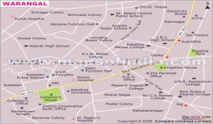
The three urban cities: Kazipet, Hanamkonda and Warangal are together known as Warangal Tri-City. The three cities are connected by the National Highway 163 (Hyderabad–Bhuvanagiri–Warangal–Bhopalpatnam). The major stations are Kazipet Junction railway station and Warangal railway station.
During the 160 years of Kakatiya rule between 1163 - 1323, Warangal was referred with various names like Orugallu, Ekasila Nagaram, or Omatikonda all these means a 'single stone' referring to a huge granite boulder present in the Warangal fort. When the Kakatiya dynasty was defeated by Delhi Sultanate in 1323, ruler Juna Khan, Crown Prince of Ghiyath al-Din Tughluq, conquered the city and renamed it as Sultanpur. Later Musunuri Nayaks recaptured Warangal in 1336 A. D. and named it Orugallu again.
It is one of eleven cities in the country to have been chosen for the Heritage City Development and Augmentation Yojana scheme by the Government of India. It was also selected as a smart city in the "fast-track competition", which makes it eligible for additional investment to improve urban infrastructure and industrial opportunities under the Smart Cities Mission.
The three urban cities: Kazipet, Hanamkonda and Warangal are together known as Warangal Tri-City. The three cities are connected by the National Highway 163 (Hyderabad–Bhuvanagiri–Warangal–Bhopalpatnam). The major stations are Kazipet Junction railway station and Warangal railway station.
During the 160 years of Kakatiya rule between 1163 - 1323, Warangal was referred with various names like Orugallu, Ekasila Nagaram, or Omatikonda all these means a 'single stone' referring to a huge granite boulder present in the Warangal fort. When the Kakatiya dynasty was defeated by Delhi Sultanate in 1323, ruler Juna Khan, Crown Prince of Ghiyath al-Din Tughluq, conquered the city and renamed it as Sultanpur. Later Musunuri Nayaks recaptured Warangal in 1336 A. D. and named it Orugallu again.
Map - Warangal
Map


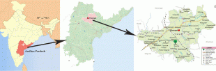


Country - India
 |
 |
| Flag of India | |
Modern humans arrived on the Indian subcontinent from Africa no later than 55,000 years ago. Their long occupation, initially in varying forms of isolation as hunter-gatherers, has made the region highly diverse, second only to Africa in human genetic diversity. Settled life emerged on the subcontinent in the western margins of the Indus river basin 9,000 years ago, evolving gradually into the Indus Valley Civilisation of the third millennium BCE. By, an archaic form of Sanskrit, an Indo-European language, had diffused into India from the northwest. (a) (b) (c), "In Punjab, a dry region with grasslands watered by five rivers (hence ‘panch’ and ‘ab’) draining the western Himalayas, one prehistoric culture left no material remains, but some of its ritual texts were preserved orally over the millennia. The culture is called Aryan, and evidence in its texts indicates that it spread slowly south-east, following the course of the Yamuna and Ganga Rivers. Its elite called itself Arya (pure) and distinguished themselves sharply from others. Aryans led kin groups organized as nomadic horse-herding tribes. Their ritual texts are called Vedas, composed in Sanskrit. Vedic Sanskrit is recorded only in hymns that were part of Vedic rituals to Aryan gods. To be Aryan apparently meant to belong to the elite among pastoral tribes. Texts that record Aryan culture are not precisely datable, but they seem to begin around 1200 BCE with four collections of Vedic hymns (Rg, Sama, Yajur, and Artharva)."
Currency / Language
| ISO | Currency | Symbol | Significant figures |
|---|---|---|---|
| INR | Indian rupee | ₹ | 2 |
| ISO | Language |
|---|---|
| AS | Assamese language |
| BN | Bengali language |
| BH | Bihari languages |
| EN | English language |
| GU | Gujarati language |
| HI | Hindi |
| KN | Kannada language |
| ML | Malayalam language |
| MR | Marathi language |
| OR | Oriya language |
| PA | Panjabi language |
| TA | Tamil language |
| TE | Telugu language |
| UR | Urdu |