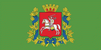
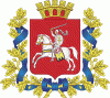
Vitebsk Region (Vitebsk Oblast)
 |
 |
As of a 2019, the region had a population of 1,135,731. It has the lowest population density in Belarus at 30.6 p/km².
Important cities within the region include Vitebsk, Orsha, Polotsk, and Novopolotsk.
Vitebsk Region covers an area of 40,000 km², which is about 19.4% of the national total. It is bordered on the north by Pskov Oblast of Russia, by Smolensk Oblast of Russia on the east, on the south by Minsk Region and by Mogilev Region, on the southwest by Minsk Region and Grodno Region, and on the west and northwest by Vilnius and Utena counties of Lithuania and Augšdaugava, Krāslava and Ludza municipalities of Latvia.
The northern extreme point of Belarus is situated in Verkhnyadzvinsk District of Vitebsk Region, north of Lake Osveya.
In 2000 Belarusian scientists Alexey Solomonov and Valery Anoshko published a report in which they stated that the geographic centre of Europe was located near Lake Sho (Шо) in the Vitebsk Region.
The region is known for its numerous lakes. The largest lakes of the Vitebsk Region are: Osveyskoye (2nd largest in Belarus), Lukomskoye (4th largest), Drivyaty (5th largest in Belarus and the largest of Braslav Lakes), Nescherdo, Snudy, Lisno, Ezerische, Strusto, Richi, Losvido, Lepelskoye.
The region has more national parks, nature reserves, and wildlife preserves of national importance than any other region of Belarus. Braslav Lakes and Naroch National Parks and Berezinski Biosphere Reserve comprise 3,4% of the whole region's territory, and 22 wildlife preserves of national importance make up 4,1% of the region.
Map - Vitebsk Region (Vitebsk Oblast)
Map


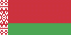
Country - Belarus
 |
 |
| Flag of Belarus | |
Until the 20th century, different states at various times controlled the lands of modern-day Belarus, including Kievan Rus', the Principality of Polotsk, the Grand Duchy of Lithuania, the Polish–Lithuanian Commonwealth, and the Russian Empire. In the aftermath of the Russian Revolution in 1917, different states arose competing for legitimacy amid the Civil War, ultimately ending in the rise of the Byelorussian SSR, which became a founding constituent republic of the Soviet Union in 1922. After the Polish-Soviet War, Belarus lost almost half of its territory to Poland. Much of the borders of Belarus took their modern shape in 1939, when some lands of the Second Polish Republic were reintegrated into it after the Soviet invasion of Poland, and were finalized after World War II. During World War II, military operations devastated Belarus, which lost about a quarter of its population and half of its economic resources. The republic was redeveloped in the post-war years. In 1945, the Byelorussian SSR became a founding member of the United Nations, along with the Soviet Union.
Currency / Language
| ISO | Currency | Symbol | Significant figures |
|---|---|---|---|
| BYN | Belarusian ruble | Br | 2 |
| ISO | Language |
|---|---|
| BE | Belarusian language |
| RU | Russian language |


