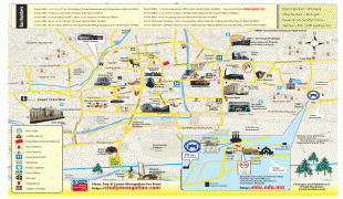
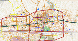
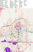
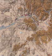
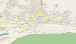
Ulan Bator (Ulan Bator)
 |
 |
During its early years, as Örgöö (anglicized as Urga), it became Mongolia's preeminent religious center and seat of the Jebtsundamba Khutuktu, the spiritual head of the Gelug lineage of Tibetan Buddhism in Mongolia. Following the regulation of Qing-Russian trade by the Treaty of Kyakhta in 1727, a caravan route between Beijing and Kyakhta opened up, along which the city was eventually settled. With the collapse of the Qing Empire in 1911, the city was a focal point for independence efforts, leading to the proclamation of the Bogd Khanate in 1911 led by the 8th Jebtsundamba Khutuktu, or Bogd Khan, and again during the communist revolution of 1921. With the proclamation of the Mongolian People's Republic in 1924, the city was officially renamed Ulaanbaatar and declared the country's capital. Modern urban planning began in the 1950s, with most of the old Ger districts replaced by Soviet-style flats. In 1990, Ulaanbaatar was a major site of demonstrations that led to Mongolia's transition to democracy and a market economy. Since 1990, an influx of migrants from the rest of the country has led to an explosive growth in its population, a major portion of whom live in Ger districts, which has led to harmful air pollution in winter.
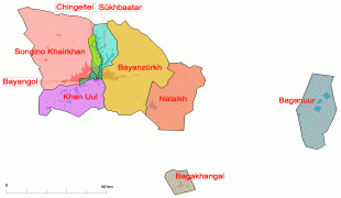
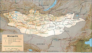
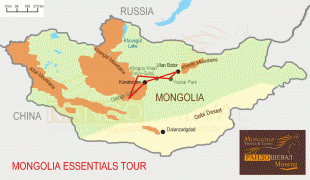
Governed as an independent municipality, Ulaanbaatar is surrounded by Töv Province, whose capital Zuunmod lies 43 km south of the city. With a population of just over 1.5 million, it contains almost half of the country's total population. As the country's primate city, it serves as the cultural, industrial and financial heart as well as the center of Mongolia's transport network, connected by rail to both the Trans-Siberian Railway in Russia and the Chinese railway system.
The city at its establishment in 1639 was referred to as Örgöö (Өргөө). This name was eventually adapted as Urga in the West. By 1651, it began to be referred to as Nomiĭn Khüree (Номын хүрээ), and by 1706 it was referred to as Ikh Khüree (Их хүрээ). The Chinese equivalent, Dà Kùlún (大庫倫, Да Хүрээ), was rendered into Western languages as Kulun or Kuren.
Other names include Bogdiin Khuree (Богдын хүрээ), or simply Khüree (Хүрээ), itself a term originally referring to an enclosure or settlement.
Upon independence in 1911, with both the secular government and the Bogd Khan's palace present, the city's name was changed to Niĭslel Khüree (Нийслэл Хүрээ).
When the city became the capital of the new Mongolian People's Republic in 1924, its name was changed to Ulaanbaatar.
In the Western world, Ulaanbaatar continued to be generally known as Urga or Khuree until 1924, and afterward as Ulan Bator (a spelling derived from the Russian Улан-Батор). This form was defined two decades before the Mongolian name got its current Cyrillic spelling and transliteration (1941–1950); however, the name of the city was spelled Ulaanbaatar koto during the decade in which Mongolia used the Latin alphabet.
Today, the city is referred to simply as khot (хот), as well as UB (you-be), from the English transliteration.
Map - Ulan Bator (Ulan Bator)
Map


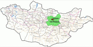


Country - Mongolia
 |
|
| Flag of Mongolia | |
The territory of modern-day Mongolia has been ruled by various nomadic empires, including the Xiongnu, the Xianbei, the Rouran, the First Turkic Khaganate, and others. In 1206, Genghis Khan founded the Mongol Empire, which became the largest contiguous land empire in history. His grandson Kublai Khan conquered China proper and established the Yuan dynasty. After the collapse of the Yuan, the Mongols retreated to Mongolia and resumed their earlier pattern of factional conflict, except during the era of Dayan Khan and Tumen Zasagt Khan. In the 16th century, Tibetan Buddhism spread to Mongolia, being further led by the Manchu-founded Qing dynasty, which absorbed the country in the 17th century. By the early 20th century, almost one-third of the adult male population were Buddhist monks. After the collapse of the Qing dynasty in 1911, Mongolia declared independence, and achieved actual independence from the Republic of China in 1921. Shortly thereafter, the country became a satellite state of the Soviet Union, which had aided its independence from China. In 1924, the Mongolian People's Republic was founded as a socialist state. After the anti-communist revolutions of 1989, Mongolia conducted its own peaceful democratic revolution in early 1990. This led to a multi-party system, a new constitution of 1992, and transition to a market economy.
Currency / Language
| ISO | Currency | Symbol | Significant figures |
|---|---|---|---|
| MNT | Mongolian tögrög | ₮ | 2 |
| ISO | Language |
|---|---|
| MN | Mongolian language |
| RU | Russian language |