Tinian International Airport (Tinian International Airport)
Tinian International Airport, also known as West Tinian Airport, is a public airport located on Tinian Island in the United States Commonwealth of the Northern Mariana Islands. This airport is owned by Commonwealth Ports Authority.
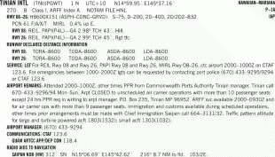
This airport is assigned a three-letter location identifier of TNI by the Federal Aviation Administration, but the International Air Transport Association (IATA) airport code is TIQ (IATA assigned TNI to Satna Airport in India). The International Civil Aviation Organization (ICAO) airport code is PGWT. Tinian International Airport is the hub of Star Marianas Air.
The airport was established on the site of the World War II era West Field.
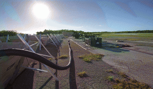
Tinian International Airport covers an area of 1,416 acre which contains one paved runway (8/26) measuring 8,600 x 150 ft (2,621 x 46 m).
For 12-month period ending March 31, 2006, the airport had 17,829 aircraft operations, an average of 48 per day: 84% air taxi, 16% general aviation and <1% military.
The head office of Star Marianas Air is in Hangar 1 at the airport.
In May 2012, the United States Marine Corps VMFA-121 operated its F/A-18D Hornets from the airport using M-31 expeditionary aircraft arresting gear systems similar to arresting systems used aboard aircraft carriers during Exercise Geiger Fury.
In 2019 the Commonwealth of the Northern Mariana Islands acting through the Commonwealth Ports Authority and the United States Department of Defense signed an agreement to operate a divert airfield at the airport in case Anderson Air Force Base in Guam is unable to be used.
This airport is assigned a three-letter location identifier of TNI by the Federal Aviation Administration, but the International Air Transport Association (IATA) airport code is TIQ (IATA assigned TNI to Satna Airport in India). The International Civil Aviation Organization (ICAO) airport code is PGWT. Tinian International Airport is the hub of Star Marianas Air.
The airport was established on the site of the World War II era West Field.
Tinian International Airport covers an area of 1,416 acre which contains one paved runway (8/26) measuring 8,600 x 150 ft (2,621 x 46 m).
For 12-month period ending March 31, 2006, the airport had 17,829 aircraft operations, an average of 48 per day: 84% air taxi, 16% general aviation and <1% military.
The head office of Star Marianas Air is in Hangar 1 at the airport.
In May 2012, the United States Marine Corps VMFA-121 operated its F/A-18D Hornets from the airport using M-31 expeditionary aircraft arresting gear systems similar to arresting systems used aboard aircraft carriers during Exercise Geiger Fury.
In 2019 the Commonwealth of the Northern Mariana Islands acting through the Commonwealth Ports Authority and the United States Department of Defense signed an agreement to operate a divert airfield at the airport in case Anderson Air Force Base in Guam is unable to be used.
| IATA Code | TIQ | ICAO Code | PGWT | FAA Code | |
|---|---|---|---|---|---|
| Telephone | Fax | ||||
| Home page |
Map - Tinian International Airport (Tinian International Airport)
Map


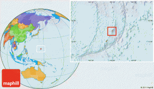
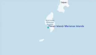
Country - Northern_Mariana_Islands
 |
 |
The United States Department of the Interior cites a landmass of 183.5 sqmi. According to the 2020 United States Census, 47,329 people were living in the CNMI at that time. The vast majority of the population resides on Saipan, Tinian, and Rota. The other islands of the Northern Marianas are sparsely inhabited; the most notable among these is Pagan, which for various reasons over the centuries has experienced major population flux, but formerly had residents numbering in the thousands.
Currency / Language
| ISO | Currency | Symbol | Significant figures |
|---|---|---|---|
| USD | United States dollar | $ | 2 |
| ISO | Language |
|---|---|
| CH | Chamorro language |
| ZH | Chinese language |
| EN | English language |
| TL | Tagalog language |