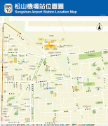
Taipei Songshan Airport (Taipei Songshan Airport)
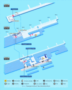
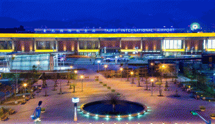
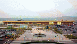
Taipei Songshan Airport is a regional airport and military airbase located in Songshan District, Taipei, Taiwan. The airport covers an area of 182 ha.
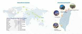
The civilian section of Songshan Airport has scheduled flights to domestic destinations in Taiwan and international destinations including Seoul, Tokyo, and select cities in mainland China. Songshan serves only a small portion of the international flights for Taipei compared to the larger Taoyuan International Airport. Songshan Airport is also the base of certain Republic of China Air Force units as part of the Songshan Air Force Base. The Songshan Base Command's main mission is to serve the President and Vice President of the Republic of China.
The airport was built in 1936 during Japanese rule with its origins as a Japanese military airbase, the Taihoku Airfield (臺北飛行場), also known as. After World War II, in 1946, it was taken over by the Republic of China Air Force. Before the end of the Chinese Civil War and the establishment of the People's Republic of China, the airport provided flight routes between Shanghai and Taipei, occasionally via Fuzhou. Shared military and civilian use—both domestic and international—began on 16 April 1950 in the reconstructed Civil Aeronautics Administration Taipei Airport (交通部民用航空局台北航空站). Domestic destinations have been Kaohsiung, Hualien, Taichung, Penghu, and Tainan. The first international destinations were Seattle, Tokyo, Busan, Manila, Bangkok, and Hong Kong. The first international airlines included Northwest Airlines, Pan Am, and Hong Kong Airways (now Cathay Pacific). Later, the airport became too small to handle an increased number of passengers, even after a series of expansions. This later worsened when new wide-body jets became common at the airport. Therefore, all international activities were relocated to Taoyuan International Airport (then known as Chiang Kai-shek International) after its inauguration on 26 February 1979. Consequently, the passenger load at the airport dropped from 6.2 million in 1978 to 2.9 million in 1979 (a 53% decrease). At its peak in 1997, the airport handled over 15.3 million passengers annually.
Service to Taichung and Chiayi was stopped in mid-2007 after the load factor dropped significantly due to the Taiwan High Speed Rail's start of revenue service in January 2007. Passenger volume decreased from 6.7 million in 2006 to 4.4 million in 2007 (a 34% decrease). Also due to the opening of the high speed rail line, on 1 March 2008, Uni Air suspended its service to Kaohsiung, while Far Eastern Air Transport suspended its service to Tainan. TransAsia Airways decided to stop flights to Tainan and Kaohsiung after 1 August 2008.
In early 1999 when the construction of Taipei 101 had just started, Taiwan's Civil Aeronautics Administration changed this airport's certain SID and STAR procedures to avoid possible collision with the building. The 677-meter Fuxing North Road Underground Passage (復興北路車行地下道) was constructed between 1997 and 2006 under this airport's runway to link the north and south side of this airport.
Regular cross-Strait charter flights to China started on 4 July 2008, with Songshan receiving the majority of flights. Direct flights to China were an issue of contention. Then-mayor Ma Ying-jeou had been pressing to make Songshan Airport Taipei's main International terminal, citing that its location close to the city center would make it preferable for business travelers. However, building height restrictions around the airport raised concerns about flight safety, blocking of radio communications, noise pollution, and a reduced number of flights.
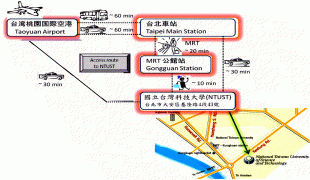
The continuing growth of Taipei City means that Songshan airport is situated in the heart of downtown Taipei. Compared to Taiwan Taoyuan International Airport, Songshan Airport saves travelers about 30 minutes due to its location inside Taipei City's central business district, but the city suffers from the noise, pollution, restrictions on urban planning, and traffic congestion the airport brings about. In the 2002 and 2006 Taipei Mayor Election DPP candidates Lee Ying-yuan and Frank Hsieh both proposed the plan to close Songshan Airport, and developed its land into road, huge park, detention basin and sports arena, since the Taiwan High Speed Rail could quickly take up the traffic load between Taipei and western Taiwan cities, and the remaining service to outlying islands and eastern Taiwan could be easily taken over by the Taiwan Taoyuan International Airport after the completion of the Taoyuan International Airport Access MRT System by the end of 2016. Also, the MRT system will make the international potential of Songshan airport less attractive. The Songshan Airport closing proposal was deferred under the Taipei City Government which has long been dominated by the Pan-Blue Coalition, who prefers the downtown airport connection concept with Shanghai, Seoul, and Tokyo.
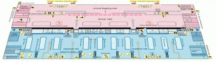
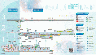
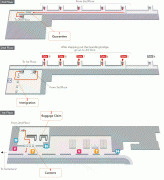
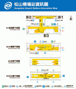
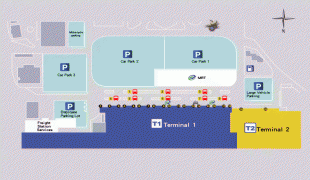
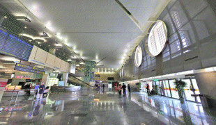
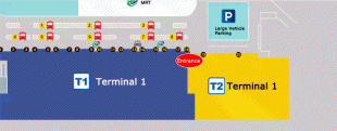
Due to the introduction of Taiwan-China flights and future international potential, the airport is undergoing extensive renovations, the first phase of which is expected to be completed by October 2010. The second and third phase renovations are expected to be completed by March and October 2011, respectively. However, as of November 2011 renovations are still in progress. A new international cargo terminal is being built in anticipation of a new air route between Taiwan and Japan. The unused Terminal 2 was refurbished to accommodate arriving flights while the main Terminal, now Terminal 1, was rearranged to handle increased passenger traffic. On 29 March 2011, the renovated Terminal 2 was re-opened to handle domestic flights.
The civilian section of Songshan Airport has scheduled flights to domestic destinations in Taiwan and international destinations including Seoul, Tokyo, and select cities in mainland China. Songshan serves only a small portion of the international flights for Taipei compared to the larger Taoyuan International Airport. Songshan Airport is also the base of certain Republic of China Air Force units as part of the Songshan Air Force Base. The Songshan Base Command's main mission is to serve the President and Vice President of the Republic of China.
The airport was built in 1936 during Japanese rule with its origins as a Japanese military airbase, the Taihoku Airfield (臺北飛行場), also known as. After World War II, in 1946, it was taken over by the Republic of China Air Force. Before the end of the Chinese Civil War and the establishment of the People's Republic of China, the airport provided flight routes between Shanghai and Taipei, occasionally via Fuzhou. Shared military and civilian use—both domestic and international—began on 16 April 1950 in the reconstructed Civil Aeronautics Administration Taipei Airport (交通部民用航空局台北航空站). Domestic destinations have been Kaohsiung, Hualien, Taichung, Penghu, and Tainan. The first international destinations were Seattle, Tokyo, Busan, Manila, Bangkok, and Hong Kong. The first international airlines included Northwest Airlines, Pan Am, and Hong Kong Airways (now Cathay Pacific). Later, the airport became too small to handle an increased number of passengers, even after a series of expansions. This later worsened when new wide-body jets became common at the airport. Therefore, all international activities were relocated to Taoyuan International Airport (then known as Chiang Kai-shek International) after its inauguration on 26 February 1979. Consequently, the passenger load at the airport dropped from 6.2 million in 1978 to 2.9 million in 1979 (a 53% decrease). At its peak in 1997, the airport handled over 15.3 million passengers annually.
Service to Taichung and Chiayi was stopped in mid-2007 after the load factor dropped significantly due to the Taiwan High Speed Rail's start of revenue service in January 2007. Passenger volume decreased from 6.7 million in 2006 to 4.4 million in 2007 (a 34% decrease). Also due to the opening of the high speed rail line, on 1 March 2008, Uni Air suspended its service to Kaohsiung, while Far Eastern Air Transport suspended its service to Tainan. TransAsia Airways decided to stop flights to Tainan and Kaohsiung after 1 August 2008.
In early 1999 when the construction of Taipei 101 had just started, Taiwan's Civil Aeronautics Administration changed this airport's certain SID and STAR procedures to avoid possible collision with the building. The 677-meter Fuxing North Road Underground Passage (復興北路車行地下道) was constructed between 1997 and 2006 under this airport's runway to link the north and south side of this airport.
Regular cross-Strait charter flights to China started on 4 July 2008, with Songshan receiving the majority of flights. Direct flights to China were an issue of contention. Then-mayor Ma Ying-jeou had been pressing to make Songshan Airport Taipei's main International terminal, citing that its location close to the city center would make it preferable for business travelers. However, building height restrictions around the airport raised concerns about flight safety, blocking of radio communications, noise pollution, and a reduced number of flights.
The continuing growth of Taipei City means that Songshan airport is situated in the heart of downtown Taipei. Compared to Taiwan Taoyuan International Airport, Songshan Airport saves travelers about 30 minutes due to its location inside Taipei City's central business district, but the city suffers from the noise, pollution, restrictions on urban planning, and traffic congestion the airport brings about. In the 2002 and 2006 Taipei Mayor Election DPP candidates Lee Ying-yuan and Frank Hsieh both proposed the plan to close Songshan Airport, and developed its land into road, huge park, detention basin and sports arena, since the Taiwan High Speed Rail could quickly take up the traffic load between Taipei and western Taiwan cities, and the remaining service to outlying islands and eastern Taiwan could be easily taken over by the Taiwan Taoyuan International Airport after the completion of the Taoyuan International Airport Access MRT System by the end of 2016. Also, the MRT system will make the international potential of Songshan airport less attractive. The Songshan Airport closing proposal was deferred under the Taipei City Government which has long been dominated by the Pan-Blue Coalition, who prefers the downtown airport connection concept with Shanghai, Seoul, and Tokyo.
Due to the introduction of Taiwan-China flights and future international potential, the airport is undergoing extensive renovations, the first phase of which is expected to be completed by October 2010. The second and third phase renovations are expected to be completed by March and October 2011, respectively. However, as of November 2011 renovations are still in progress. A new international cargo terminal is being built in anticipation of a new air route between Taiwan and Japan. The unused Terminal 2 was refurbished to accommodate arriving flights while the main Terminal, now Terminal 1, was rearranged to handle increased passenger traffic. On 29 March 2011, the renovated Terminal 2 was re-opened to handle domestic flights.
| IATA Code | TSA | ICAO Code | RCSS | FAA Code | |
|---|---|---|---|---|---|
| Telephone | Fax | ||||
| Home page |
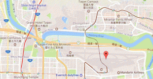
Map - Taipei Songshan Airport (Taipei Songshan Airport)
Map


Country - Taiwan
 |
 |
| Flag of Taiwan | |
* in East Asia. It is located at the junction of the East and South China Seas in the northwestern Pacific Ocean, with the People's Republic of China (PRC) to the northwest, Japan to the northeast, and the Philippines to the south. The territories controlled by the ROC consist of 168 islands, with a combined area of 36193 km2. The main island of Taiwan, also known as Formosa, has an area of 35,808 km2, with mountain ranges dominating the eastern two-thirds and plains in the western third, where its highly urbanised population is concentrated. The capital, Taipei, forms along with New Taipei City and Keelung the largest metropolitan area of Taiwan. Other major cities include Taoyuan, Taichung, Tainan, and Kaohsiung. With around 23.9 million inhabitants, Taiwan is among the most densely populated countries in the world.
Currency / Language
| ISO | Currency | Symbol | Significant figures |
|---|---|---|---|
| TWD | New Taiwan dollar | $ | 2 |
| ISO | Language |
|---|---|
| ZH | Chinese language |