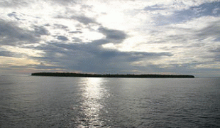
Swains Island (Swains Island)
Swains Island (Tokelauan: Olohega ; Samoan: Olosega ) is a remote coral atoll in the Tokelau Islands in the South Pacific Ocean. The island is the subject of an ongoing territorial dispute between Tokelau and the United States, which has administered it as part of American Samoa since 1925. Privately owned by the family of Eli Hutchinson Jennings since 1856, Swains Island was used as a copra plantation until 1967. It has not been permanently inhabited since 2008 but has often been visited by members of the Jennings family, scientific researchers, and amateur radio operators.
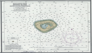
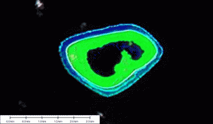
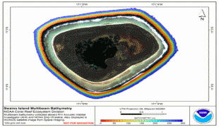
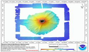
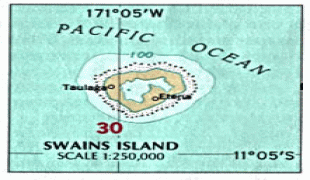
The island is located 180 km south of Fakaofo (Tokelau) and 300 km north of Savai‘i (Samoa). The land area is 2.43 km2, and the total area including the lagoon is 3.5 km2.
A persistent misconception about Swains Island is its supposed discovery on 2 March 1606 by Pedro Fernandes de Queirós, a famous Portuguese navigator who sailed for Spain. On that day, he reckoned an island at 10°36'S 171°W, and his ship's historian named it Isla de la Gente Hermosa (meaning "island of the beautiful people" in Spanish), after its inhabitants. The closest island to that reckoned location is Swains Island at 11°03'S 171°05'W, leading later authors to identify it as the same, and thus refer to it by that Spanish name or by the Spanish version of the navigator's last name, Quirós (also spelled Quiros in English). However, the island described by Queirós was significantly larger, and at the time the calculation of longitude had a much greater uncertainty than latitude, leading later scholars to conclude that the island found by Queirós was actually Rakahanga, lying 1,100 km to the east at 10°02'S 161°05'W.
Captain William L. Hudson of the USS Peacock saw the island on 1 February 1841, during the United States Exploring Expedition of 1838–42. He claimed to have learned about the island's location from a certain Captain Swain of Nantucket, and after concluding that it did not match the description by Queirós, resolved to call it Swain's Island (the apostrophe was later dropped):
"[F]rom having its position very nearly pointed out to me by Capt. Swain of Nantucket who stated to me at Tahiti that he had seen it in passing – and in consequence of its being a considerable distance in latitude from, and not agreeing in size or character with the island described by Queros – in addition to this in view of it being peopled with a beautiful race – it is uninhabited and perhaps we are the first that have ever set foot upon it – thus much for its name."
This Captain Swain has not been conclusively identified. Authors have suggested Jonathan Swain of whaler Independence in 1820, or William C. Swain of whaler George Champlain in the 1830s. Other evidence suggests Obed Swain of whaler Jefferson of Nantucket, who, unlike William C. Swain, actually was at Tahiti when the United States Exploring Expedition was there with the USS Peacock and Captain Hudson.
In Tokelauan, the main language formerly spoken on Swains Island, the island is called Olohega. The name is composed of the prefix olo-, indicating a collective noun, and the word hega, meaning a tuft of feathers tied to the end of a skipjack lure, possibly referring to the island's location at the end of the Tokelau chain. A variant of this name is Olosega, either also in Tokelauan or in Samoan, another language formerly spoken there. It should not be confused with the homonymous island in the pair Ofu-Olosega of the Manu‘a group in American Samoa.
It is also called Jennings Island, after Eli Hutchinson Jennings, who settled there in 1856 and whose family still owns and manages the island.
Map - Swains Island (Swains Island)
Map


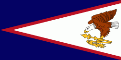
Country - American_Samoa
 |
 |
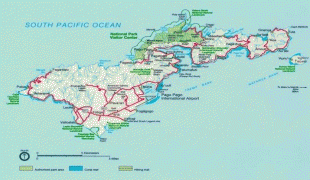
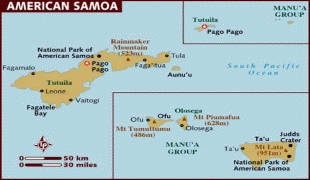
American Samoa consists of five main islands and two coral atolls; the largest and most populous island is Tutuila, with the Manuʻa Islands, Rose Atoll and Swains Island also included in the territory. All islands except for Swains Island are part of the Samoan Islands, The total land area is 199 sqkm, slightly more than Washington, D.C. As of 2022, the population of American Samoa is approximately 45,443 people, of whom the vast majority are indigenous ethnic Samoans. Most American Samoans are bilingual and can speak English and Samoan fluently.
Currency / Language
| ISO | Currency | Symbol | Significant figures |
|---|---|---|---|
| USD | United States dollar | $ | 2 |
| ISO | Language |
|---|---|
| EN | English language |
| SM | Samoan language |
| TO | Tongan language |