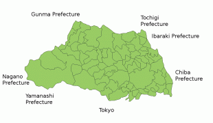
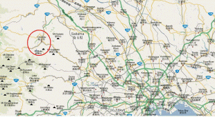
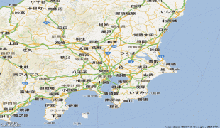
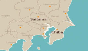
Saitama Prefecture (Saitama-ken)
 |
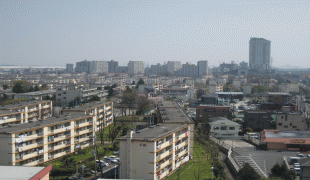
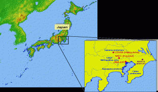
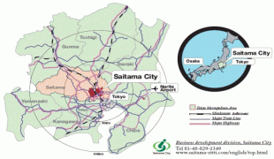
Saitama is the capital and largest city of Saitama Prefecture, with other major cities including Kawaguchi, Kawagoe, and Tokorozawa. Saitama Prefecture is part of the Greater Tokyo Area, the most populous metropolitan area in the world, and many of its cities are described as bedroom communities and suburbs of Tokyo with many residents commuting into the city each day.
According to Sendai Kuji Hongi (Kujiki), Chichibu was one of 137 provinces during the reign of Emperor Sujin. Chichibu Province was in western Saitama.
The area that would become Saitama Prefecture in the 19th century is part of Musashi Province in the Ritsuryō (or ryō-system; ritsu stands for the penal code, ryō for the administrative code) Imperial administration of antiquity (see Provinces of Japan and the 5 (go) capital area provinces (ki)/7 (shichi) circuits (dō) system) which was nominally revived in the Meiji restoration but has lost much of its administrative function since the Middle Ages. Saitama District (Saitama-gun) was one of Musashi's 21 ritsuryō districts.
In the fifth year of the Keiun era (708), deposits of copper were reported to have been found in the Chichibu District of what is now Saitama Prefecture.
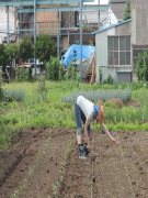
The Saitama area was historically known as a fertile agricultural region which produced much of the food for the Kantō region. During the Edo period, many fudai daimyōs ruled small domains within the Saitama area.
At the end of the early modern Edo period, large parts of present-day Saitama were part of the shogunate domain (baku-ryō) or the often subsumed holdings of smaller vassals (hatamoto-ryō) around Edo, major areas were part of the fiefdoms (-han) Kawagoe (ruled by Matsui/Matsudaira, fudai), Oshi (Okudaira-Matsudaira, fudai) and Iwatsuki (Ōoka, fudai); few territories were held by domains seated in other provinces.
In the Meiji Restoration, after being briefly united with other rural shogunate territories in Musashi under Musashi governors (Musashi chikenji), many former shogunate/hatamoto territories in Northwestern Musashi became Ōmiya Prefecture (大宮県, Ōmiya-ken), soon renamed to Urawa (浦和県, -ken) in 1868/69, with some territories held by other short-lived prefectures (Iwahana Prefecture/later mainly Gunma and Nirayama Prefecture/later mainly Shizuoka, Kanagawa and Tokyo). In the replacement of -han with -ken, the associated territorial consolidation (removal of feudal era ex-/enclaves) and first wave of prefectural mergers in 1871/72, Oshi and Iwatsuki prefectures were merged into Urawa; after consolidation, it consisted of the entire Saitama District and Northern parts of Adachi and Katsushika (But at that time, "major and minor districts", 大区, daiku and 小区, shōku, served as administrative subdivisions) and was renamed to Saitama. The government of the prefecture was to be set up in Iwatsuki Town, Saitama District in November 1871 by the Dajōkan ordinance to set up the prefecture, but ultimately remained in Urawa's previous prefectural government seat in Urawa Town in Adachi District.
Kawagoe Prefecture was consolidated with other territories into Iruma Prefecture (入間県, Iruma-ken; government seat unchanged from Kawagoe domain/prefecture: Kawagoe Town, Iruma District) which consisted of 13 districts of Musashi in the Western part of present-day Saitama. In 1873, Iruma was merged with Gunma (capital: Takasaki Town, Gunma District) to become Kumagaya (capital: Kumagaya Town, Ōsato District). But Kumagaya was split up again in 1876: The area of Kōzuke province came back as a second Gunma prefecture, and the territories in Musashi province/former Iruma prefecture were merged into Saitama. Except for the transfer of a few municipalities to Tokyo in the 1890s/1900s (see below) and several smaller, 20th century changes through cross-prefectural municipal mergers or transfers of neighbourhoods, Saitama had reached its present extent.
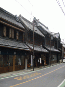
In the modern reactivation of districts as administrative unit in 1878/79, Saitama was subdivided into originally 18 districts based on the ancient divisions of Musashi, but with only nine (joint) district government offices, and the number of districts was formally merged down to nine in 1896/97: North Adachi, Iruma, Hiki, Chichibu, Kodama, Ōsato, North Saitama, South Saitama, and North Katsushika. Niikura (also known as Niiza, Shiki or Shiragi), one of the original 1878/79 modern districts, was first merged into North Adachi in 1896, but a substantial part of its former territory was subsequently transferred to the North Tama and North Toshima districts of Tokyo. In the creation of modern cities, towns and villages in 1889, these districts were subdivided into originally 40 towns and 368 villages. The first city in Saitama was only established in 1922 when Kawagoe Town from Iruma District became Kawagoe City. The prefectural capital, Urawa in North Adachi, remained a town until 1934. After the Great Shōwa mergers of the 1950s, the number of municipalities in Saitama had shrunk to 95, including 23 cities by then. The Great Heisei mergers of the 2000s pushed the number below 70.
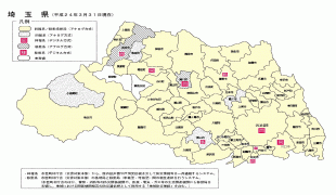
Map - Saitama Prefecture (Saitama-ken)
Map


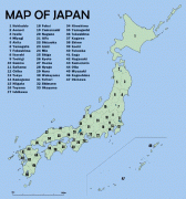

Country - Japan
 |
 |
| Flag of Japan | |
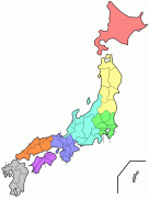
Japan is the eleventh most populous country in the world, as well as one of the most densely populated and urbanized. About three-fourths of the country's terrain is mountainous, concentrating its population of 124.8 million on narrow coastal plains. Japan is divided into 47 administrative prefectures and eight traditional regions. The Greater Tokyo Area is the most populous metropolitan area in the world, with more than 37.2 million residents.
Currency / Language
| ISO | Currency | Symbol | Significant figures |
|---|---|---|---|
| JPY | Japanese yen | ¥ | 0 |
| ISO | Language |
|---|---|
| JA | Japanese language |


