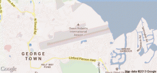
Roberts International Airport (Roberts International Airport)
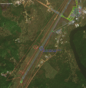
Roberts International Airport, informally also known as Robertsfield, is an international airport in the West African nation of Liberia. Located near the town of Harbel in Margibi County, the single runway airport is about 35 mi outside of the nation's capital of Monrovia, and as an origin and destination point is referred to as "Monrovia" and locally is often referred to simply as "RIA." The airport is named in honor of Joseph Jenkins Roberts, the first President of Liberia.
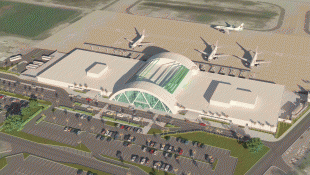
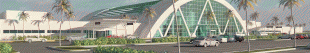
The airport is the nation's busiest and most important aviation facility, currently hosting the country's only scheduled commercial airline services, with direct connections to several major cities in West Africa as well as flights to Europe on Brussels Airlines. The airport reportedly served 228,000 passengers annually in 2018 and recently underwent a major expansion, including the opening of a new passenger terminal. The facility with its 11000 ft long runway was an emergency landing site for the United States' Space Shuttle program and is one of only two with paved runways in the country. While Monrovia's secondary airport, Spriggs Payne, is much closer to the city center and possesses the nation's only other paved runway, it has not had scheduled commercial service since ASKY Airlines suspended service in November 2014.
The airport is the nation's busiest and most important aviation facility, currently hosting the country's only scheduled commercial airline services, with direct connections to several major cities in West Africa as well as flights to Europe on Brussels Airlines. The airport reportedly served 228,000 passengers annually in 2018 and recently underwent a major expansion, including the opening of a new passenger terminal. The facility with its 11000 ft long runway was an emergency landing site for the United States' Space Shuttle program and is one of only two with paved runways in the country. While Monrovia's secondary airport, Spriggs Payne, is much closer to the city center and possesses the nation's only other paved runway, it has not had scheduled commercial service since ASKY Airlines suspended service in November 2014.
| IATA Code | ROB | ICAO Code | GLRB | FAA Code | |
|---|---|---|---|---|---|
| Telephone | +231 77 000 827 | Fax | +231 77 013 135 | ||
| Home page | Hyperlink |
Map - Roberts International Airport (Roberts International Airport)
Map


Country - Liberia
 |
 |
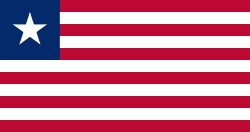
| Flag of Liberia | |
Liberia began in the early 19th century as a project of the American Colonization Society (ACS), which believed black people would face better chances for freedom and prosperity in Africa than in the United States. Between 1822 and the outbreak of the American Civil War in 1861, more than 15,000 freed and free-born African Americans, along with 3,198 Afro-Caribbeans, relocated to Liberia. Gradually developing an Americo-Liberian identity, the settlers carried their culture and tradition with them. Liberia declared independence on July 26, 1847, which the U.S. did not recognize until February 5, 1862.
Currency / Language
| ISO | Currency | Symbol | Significant figures |
|---|---|---|---|
| LRD | Liberian dollar | $ | 2 |
| ISO | Language |
|---|---|
| EN | English language |