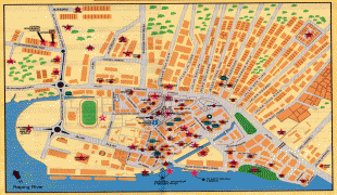
Road Town (Road Town)
The name is derived from the nautical term "the roads", a place less sheltered than a harbour but which ships can easily get to. A 28 ha development called Wickham's Cay, consisting of two areas that were reclaimed from the sea and a marina, have enabled Road Town to emerge as a haven for yacht chartering and a centre of tourism. This area is the newest part of the city and the hub for the new commercial and administrative buildings of the BVI. The oldest building in Road Town, HM Prison on Main Street, was built in 1774.
The British Virgin Islands enjoy a tropical climate, moderated by trade winds. Temperatures vary little throughout the year. In the capital, Road Town, typical daily maxima are around 32 °C in the summer and 29 °C in the winter. Typical daily minima are around 24 °C in the summer and 21 °C in the winter. Rainfall averages about 1150 mm per year, higher in the hills and lower on the coast. Rainfall can be quite variable, but the wettest months on average are September to November and the driest months on average are February and March. Hurricanes occasionally hit the islands, with the hurricane season running from June to November.
Map - Road Town (Road Town)
Map


Country - British_Virgin_Islands
 |
 |
The British Virgin Islands consist of the main islands of Tortola, Virgin Gorda, Anegada and Jost Van Dyke, along with more than 50 other smaller islands and cays. About 16 of the islands are inhabited. The capital, Road Town, is on Tortola, the largest island, which is about 20 km long and 5 km wide. The islands had a population of 28,054 at the 2010 Census, of whom 23,491 lived on Tortola; current estimates put the population at 35,802 (July 2018).
Currency / Language
| ISO | Currency | Symbol | Significant figures |
|---|---|---|---|
| USD | United States dollar | $ | 2 |
| ISO | Language |
|---|---|
| EN | English language |