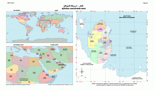
Qatar (State of Qatar)
 |
|
| Flag of Qatar | |
Qatar has been ruled as a hereditary monarchy by the House of Thani since Mohammed bin Thani signed a treaty with the British in 1868 that recognised its separate status. Following Ottoman rule, Qatar became a British protectorate in 1916, and gained independence in 1971. The current emir is Tamim bin Hamad Al Thani, who holds nearly all executive and legislative authority under the Constitution of Qatar, as well as controlling the judiciary. He appoints the prime minister and cabinet. The partially-elected Consultative Assembly can block legislation and has a limited ability to dismiss ministers.
In early 2017, the total population of Qatar was 2.6 million, with 313,000 of them Qatari citizens and 2.3 million expatriates. Its official religion is Islam. In terms of income, the country has the fourth-highest GDP (PPP) per capita in the world, and the eleventh-highest GNI per capita (Atlas method). Qatar ranks 42nd in the Human Development Index, the third-highest HDI in the Arab world. It is a high-income economy, backed by the world's third-largest natural gas reserves and oil reserves. Qatar is one of the world's largest exporters of liquefied natural gas, and the world's largest emitter of carbon dioxide per capita.
In the 21st century, Qatar emerged as a middle power in the Arab world through its resource-wealth, as well as its globally expanding media group, Al Jazeera Media Network, and reportedly supporting several rebel groups financially during the Arab Spring. Qatar forms part of the Gulf Cooperation Council. Qatar's human rights record has been regarded by academics and non-governmental organisations as being generally poor, with restrictions on civil liberties such as the freedoms of association, expression and the press, as well as its treatment of thousands of migrant workers amounting to forced labour for projects in the country. The 2022 FIFA World Cup was awarded to Qatar under controversial circumstances, making it the first Arab country and the first in the Middle East to host the event.
Pliny the Elder, a Roman writer, documented the earliest account pertaining to the inhabitants of the peninsula around the mid-first century AD, referring to them as the Catharrei, a designation that may have derived from the name of a prominent local settlement. A century later, Ptolemy produced the first known map to depict the peninsula, referring to it as Catara. The map also referenced a town named "Cadara" to the east of the peninsula. The term "Catara" (inhabitants, Cataraei) was exclusively used until the 18th century, after which "Katara" emerged as the most commonly recognised spelling. Eventually, after several variations — "Katr", "Kattar" and "Guttur" — the modern derivative Qatar was adopted as the country's name.
In Standard Arabic, the name is pronounced, while in the local dialect it is.
English speakers use different approximate pronunciations of the name as the Arabic pronunciations use sounds not often used in English.
Currency / Language
| ISO | Currency | Symbol | Significant figures |
|---|---|---|---|
| QAR | Qatari riyal | رق | 2 |
| ISO | Language |
|---|---|
| AR | Arabic language |
| ES | Spanish language |