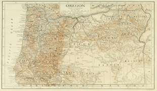
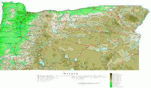
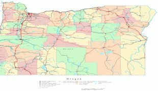
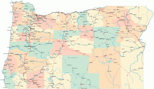
Oregon
 |
 |
Oregon has been home to many indigenous nations for thousands of years. The first European traders, explorers, and settlers began exploring what is now Oregon's Pacific coast in the early to mid-16th century. As early as 1564, the Spanish began sending vessels northeast from the Philippines, riding the Kuroshio Current in a sweeping circular route across the northern part of the Pacific. In 1592, Juan de Fuca undertook detailed mapping and studies of ocean currents in the Pacific Northwest, including the Oregon coast as well as the strait now bearing his name. The Lewis and Clark Expedition traversed Oregon in the early 1800s, and the first permanent European settlements in Oregon were established by fur trappers and traders. In 1843, an autonomous government was formed in the Oregon Country, and the Oregon Territory was created in 1848. Oregon became the 33rd state of the U.S. on February 14, 1859.
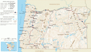
Today, with 4 million people over 98000 sqmi, Oregon is the ninth largest and 27th most populous U.S. state. The capital, Salem, is the second-most populous city in Oregon, with 169,798 residents. Portland, with 647,805, ranks as the 26th among U.S. cities. The Portland metropolitan area is the 25th largest metro area in the nation, with a population of 2,453,168.
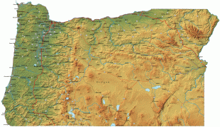
Oregon is also one of the most geographically diverse states in the U.S., marked by volcanoes, abundant bodies of water, dense evergreen and mixed forests, as well as high deserts and semi-arid shrublands. At 11249 ft, Mount Hood, a stratovolcano, is the state's highest point. Oregon's only national park, Crater Lake National Park, comprises the caldera surrounding Crater Lake, the deepest lake in the United States. The state is also home to the single largest organism in the world, Armillaria ostoyae, a fungus that runs beneath 8.9 km2 of the Malheur National Forest.
Oregon's economy has historically been powered by various forms of agriculture, fishing, logging, and hydroelectric power. Oregon is the top lumber producer of the contiguous United States, with the lumber industry dominating the state's economy during the 20th century. Technology is another one of Oregon's major economic forces, beginning in the 1970s with the establishment of the Silicon Forest and the expansion of Tektronix and Intel. Sportswear company Nike, Inc., headquartered in Beaverton, is the state's largest public corporation with an annual revenue of $30.6 billion.
The origin of the state's name is a mystery. The earliest evidence of the name Oregon has Spanish origins. The term "orejón" (meaning "big ear") comes from the historical chronicle Relación de la Alta y Baja California (1598), written by Rodrigo Montezuma of New Spain; it made reference to the Columbia River when the Spanish explorers penetrated into the North American territory that became part of the Viceroyalty of New Spain. This chronicle is the first topographical and linguistic source with respect to the place name Oregon. Another possible source is the Spanish word oregano, which refers to a plant that grows in the southern part of the region. It is also possible that the American territory was named by the Spaniards, as there is a stream in Spain called the "Arroyo del Oregón" (which is located in the province of Ciudad Real), or that the "j" in the Spanish phrase "El Orejón" was later corrupted into a "g".
Another early use of the name, spelled Ouragon, was by Major Robert Rogers in a 1765 petition to the Kingdom of Great Britain. The term referred to the then-mythical River of the West (the Columbia River). By 1778, the spelling had shifted to Oregon. Rogers wrote: "...from the Great Lakes towards the Head of the Mississippi, and from thence to the River called by the Indians Ouragon..."
One theory is that the name comes from the French word ouragan ("windstorm" or "hurricane"), which was applied to the River of the West based on Native American tales of powerful Chinook winds on the lower Columbia River, or perhaps from first-hand French experience with the Chinook winds of the Great Plains. At the time, the River of the West was thought to rise in western Minnesota and flow west through the Great Plains.
Joaquin Miller wrote in Sunset magazine in 1904: "The name, Oregon, is rounded down phonetically, from Ouve água—Oragua, Or-a-gon, Oregon—given probably by the same Portuguese navigator that named the Farallones after his first officer, and it literally, in a large way, means cascades: 'Hear the waters.' You should steam up the Columbia and hear and feel the waters falling out of the clouds of Mount Hood to understand entirely the full meaning of the name Ouve a água, Oregon."
Another account, endorsed as the "most plausible explanation" in the book Oregon Geographic Names, was advanced by George R. Stewart in a 1944 article in American Speech. According to Stewart, the name came from an engraver's error in a French map published in the early 18th century, on which the Ouisiconsink (Wisconsin) River was spelled "Ouaricon-sint", broken on two lines with the -sint below, so there appeared to be a river flowing to the west named "Ouaricon".
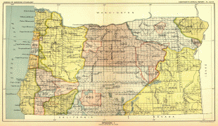
Map - Oregon
Map


Country - United_States
 |
 |
| Flag of the United States | |
Indigenous peoples have inhabited the Americas for thousands of years. Beginning in 1607, British colonization led to the establishment of the Thirteen Colonies in what is now the Eastern United States. They quarreled with the British Crown over taxation and political representation, leading to the American Revolution and proceeding Revolutionary War. The United States declared independence on July 4, 1776, becoming the first nation-state founded on Enlightenment principles of unalienable natural rights, consent of the governed, and liberal democracy. The country began expanding across North America, spanning the continent by 1848. Sectional division surrounding slavery in the Southern United States led to the secession of the Confederate States of America, which fought the remaining states of the Union during the American Civil War (1861–1865). With the Union's victory and preservation, slavery was abolished nationally by the Thirteenth Amendment.
Currency / Language
| ISO | Currency | Symbol | Significant figures |
|---|---|---|---|
| USD | United States dollar | $ | 2 |
| ISO | Language |
|---|---|
| EN | English language |
| FR | French language |
| ES | Spanish language |


