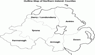
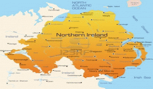
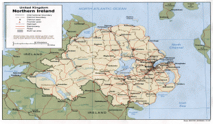
Northern Ireland (Northern Ireland)
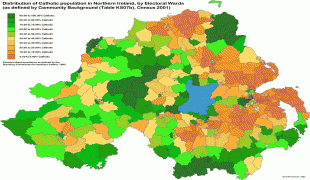
Northern Ireland was created in May 1921, when Ireland was partitioned by the Government of Ireland Act 1920, creating a devolved government for the six northeastern counties. As was intended, Northern Ireland had a unionist majority, who wanted to remain in the United Kingdom; they were generally the Protestant descendants of colonists from Britain. Meanwhile, the majority in Southern Ireland (which became the Irish Free State in 1922), and a significant minority in Northern Ireland, were Irish nationalists (generally Catholics) who wanted a united independent Ireland. Today, the former generally see themselves as British and the latter generally see themselves as Irish, while a Northern Irish or Ulster identity is claimed by a significant minority from all backgrounds.
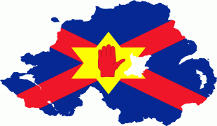
The creation of Northern Ireland was accompanied by violence both in defence of and against partition. During the conflict of 1920–22, the capital Belfast saw major communal violence, mainly between Protestant unionist and Catholic nationalist civilians. More than 500 were killed and more than 10,000 became refugees, mostly Catholics. For the next fifty years, Northern Ireland had an unbroken series of Unionist Party governments. There was informal mutual segregation by both communities, and the Unionist governments were accused of discrimination against the Irish nationalist and Catholic minority. In the late 1960s, a campaign to end discrimination against Catholics and nationalists was opposed by loyalists, who saw it as a republican front. This unrest sparked the Troubles, a thirty-year conflict involving republican and loyalist paramilitaries and state forces, which claimed over 3,500 lives and injured 50,000 others. The 1998 Good Friday Agreement was a major step in the peace process, including paramilitary disarmament and security normalisation, although sectarianism and segregation remain major social problems, and sporadic violence has continued.
The economy of Northern Ireland was the most industrialised in Ireland at the time of partition, but soon began to decline, a decline exacerbated by the political and social turmoil of the Troubles. Its economy has grown significantly since the late 1990s. The initial growth came from the "peace dividend" and increased trade with the Republic of Ireland, continuing with a significant increase in tourism, investment, and business from around the world. Unemployment in Northern Ireland peaked at 17.2% in 1986, but dropped back down to below 10% in the 2010s, similar to the rate of the rest of the UK.
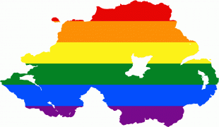
Cultural links between Northern Ireland, the rest of Ireland, and the rest of the UK are complex, with Northern Ireland sharing both the culture of Ireland and the culture of the United Kingdom. In many sports, Ireland fields a single team, with the Northern Ireland national football team being an exception to this. Northern Ireland competes separately at the Commonwealth Games, and people from Northern Ireland may compete for either Great Britain or Ireland at the Olympic Games.
The region that is now Northern Ireland was long inhabited by native Gaels who were Irish-speaking and predominantly Catholic. It was made up of several Gaelic kingdoms and territories and was part of the province of Ulster. In 1169, Ireland was invaded by a coalition of forces under the command of the English crown that quickly overran and occupied most of the island, beginning 800 years of foreign central authority. Attempts at resistance were swiftly crushed everywhere outside of Ulster. Unlike in the rest of the country, where Gaelic authority continued only in scattered, remote pockets, the major kingdoms of Ulster would mostly remain intact with English authority in the province contained to areas on the eastern coast closest to Great Britain. English power gradually eroded in the face of stubborn Irish resistance in the centuries that followed; eventually being reduced to only the city of Dublin and its suburbs. When Henry VIII launched the 16th century Tudor re-conquest of Ireland, Ulster once resisted most effectively. In the Nine Years' War (1594–1603), an alliance of Gaelic chieftains led by the two most powerful Ulster lords, Hugh Roe O'Donnell and the Earl of Tyrone fought against the English government in Ireland. The Ulster-dominated alliance represented the first Irish united front (prior resistance had always been localized). Despite being able to cement an alliance with Spain and major victories early on, inevitable defeat was virtually guaranteed following England's victory at the siege of Kinsale. In 1607, the rebellion's leaders fled to mainland Europe alongside much of Ulster's Gaelic nobility. Their lands were confiscated by the Crown and colonized with English-speaking Protestant settlers from Britain, in the Plantation of Ulster. This led to the founding of many of Ulster's towns and created a lasting Ulster Protestant community with ties to Britain. The Irish Rebellion of 1641 began in Ulster. The rebels wanted an end to anti-Catholic discrimination, greater Irish self-governance, and to roll back the Plantation. It developed into an ethnic conflict between Irish Catholics and British Protestant settlers and became part of the wider Wars of the Three Kingdoms (1639–53), which ended with the English Parliamentarian conquest. Further Protestant victories in the Williamite-Jacobite War (1688–91) solidified Anglican Protestant rule in the Kingdom of Ireland. The Williamite victories of the siege of Derry (1689) and Battle of the Boyne (1690) are still celebrated by some Protestants in Northern Ireland. Many more Scots Protestants migrated to Ulster during the Scottish famine of the 1690s.
Following the Williamite victory, and contrary to the Treaty of Limerick (1691), a series of Penal Laws were passed by the Anglican Protestant ruling class in Ireland. The intention was to disadvantage Catholics and, to a lesser extent, Presbyterians. Some 250,000 Ulster Presbyterians emigrated to the British North American colonies between 1717 and 1775. It is estimated that there are more than 27 million Scotch-Irish Americans now living in the United States, along with many Scotch-Irish Canadians in Canada. In the context of institutional discrimination, the 18th century saw secret, militant societies develop in Ulster and act on sectarian tensions in violent attacks. This escalated at the end of the century, especially during the County Armagh disturbances, where the Protestant Peep o' Day Boys fought the Catholic Defenders. This led to the founding of the Protestant Orange Order. The Irish Rebellion of 1798 was led by the United Irishmen; a cross-community Irish republican group founded by Belfast Presbyterians, which sought Irish independence. Following this, the government of the Kingdom of Great Britain pushed for the two kingdoms to be merged, in an attempt to quell violent sectarianism, remove discriminatory laws, and prevent the spread of French-style republicanism. The United Kingdom of Great Britain and Ireland was formed in 1801 and governed from London. During the 19th century, legal reforms known as the Catholic emancipation continued to remove discrimination against Catholics, and progressive programs enabled tenant farmers to buy land from landlords.
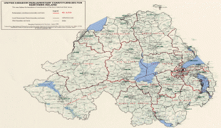
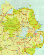
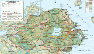
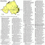
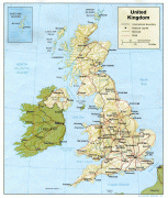
Map - Northern Ireland (Northern Ireland)
Map


Country - United_Kingdom
 |
 |
| Flag of the United Kingdom | |
The United Kingdom has evolved from a series of annexations, unions and separations of constituent countries over several hundred years. The Treaty of Union between the Kingdom of England (which included Wales, annexed in 1542) and the Kingdom of Scotland in 1707 formed the Kingdom of Great Britain. Its union in 1801 with the Kingdom of Ireland created the United Kingdom of Great Britain and Ireland. Most of Ireland seceded from the UK in 1922, leaving the present United Kingdom of Great Britain and Northern Ireland, which formally adopted that name in 1927. The nearby Isle of Man, Guernsey and Jersey are not part of the UK, being Crown Dependencies with the British Government responsible for defence and international representation. There are also 14 British Overseas Territories, the last remnants of the British Empire which, at its height in the 1920s, encompassed almost a quarter of the world's landmass and a third of the world's population, and was the largest empire in history. British influence can be observed in the language, culture and the legal and political systems of many of its former colonies.
Currency / Language
| ISO | Currency | Symbol | Significant figures |
|---|---|---|---|
| GBP | Pound sterling | £ | 2 |
| ISO | Language |
|---|---|
| EN | English language |
| GD | Gaelic language |
| CY | Welsh language |