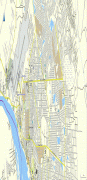
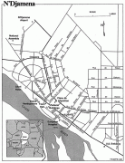
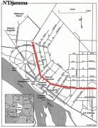
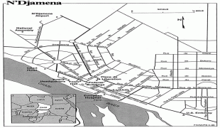
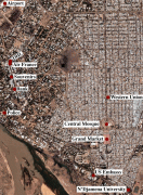
N'Djamena
 |
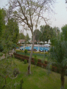
The city serves as the centre of economic activity in Chad. Meat, fish and cotton processing are the chief industries, and it is a regional market for livestock, salt, dates, and grains.
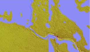
It is a port city located at the confluence of the Logone River with the Chari River, forming a transborder agglomeration with the city of Kousséri (in Cameroon), capital of the Department of Logone-et-Chari, which is on the west bank of both rivers. In 2014, it had 1,093,492 inhabitants. It is Africa's most polluted city.
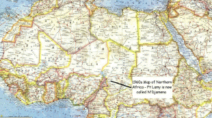
N'Djamena was founded as Fort-Lamy by French commander Émile Gentil on 29 May 1900, and named after Amédée-François Lamy, an army officer who had been killed in the Battle of Kousséri about a month earlier. It was a major trading city and became the capital of the region and nation.
During the Second World War, the French relied upon the city's airport to move troops and supplies. On 21 January 1942, a lone German He 111 of the Sonderkommando Blaich successfully bombed the airfield at Fort-Lamy, destroying oil supplies and ten aircraft. Fort-Lamy received its first bank branch in 1950, when the Bank of West Africa (BAO) opened a branch there.
On 6 April 1973, President François Tombalbaye changed its name to N'Djamena (taken from the Arabic name of a nearby village, Niǧāmīnā, meaning "place of rest") as part of his authenticité program of Africanization. The city was occupied by Libya during the 1980–81 Libyan intervention as part of the Chadian–Libyan conflict, and the associated Transitional Government of National Unity.
The city was partly destroyed during the Chadian Civil War, in 1979 and again in 1980. In these years, almost all of the population fled the town, searching for refuge on the opposite bank of the Chari River in Cameroon, next to the city of Kousseri. The residents did not return until 1981–82, after the end of the clashes. Until 1984, facilities and services were subject to strict rationing, and schools remained closed.
The period of turmoil in the city was started by the abortive coup attempted by the northerner Prime Minister Hissène Habré against the southerner President Félix Malloum: while Malloum and the national army loyal to him were defeated, the intervention in the battle of other northern factions rival to that of Habré complicated the situation. A temporary truce was reached in 1979 through international mediation, establishing the warlord Goukouni Oueddei as head of a government of national unity with his rival Habré as Defense Minister. The intense rivalry between Goukouni and Habré caused the eruption of new clashes in the city in 1980; N’Djamena found itself divided into sectors controlled by the various warlords. The tug-of-war reached a conclusion after many months only when Goukouni asked for the intervention of the Libyans, whose tanks overwhelmed Habré's defenses in the capital.
Following differences between Goukouni and Muammar Gaddafi and international disapproval of Libyan intervention, the Libyan troops left the capital and Chad in 1981. This opened the door to Habré, who marched on N’Djamena, occupying the city with little resistance in 1982 and installing himself as the new president. He was eventually dislodged in a similar fashion in 1990 by a former general of his, Idriss Déby, the head of state of Chad.
The city had only 9,976 inhabitants in 1937, but a decade later, in 1947, the population had almost doubled to 18,435. In 1968, after independence, the population reached 126,483. In 1993, it surpassed half a million with 529,555. A good deal of this growth has been due to refugees fleeing into N’Djamena for security, although many people fled N’Djamena, also depending on the political situation. The city surpassed the million mark in population by the early 2010s.
Map - N'Djamena
Map


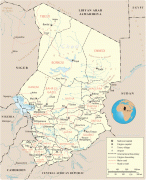
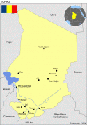

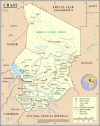
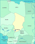
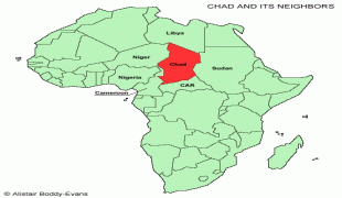
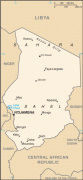
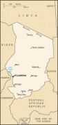
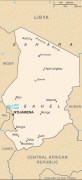

Country - Chad
 |
 |
| Flag of Chad | |
Chad has several regions: a desert zone in the north, an arid Sahelian belt in the centre and a more fertile Sudanian Savanna zone in the south. Lake Chad, after which the country is named, is the second-largest wetland in Africa. Chad's official languages are Arabic and French. It is home to over 200 different ethnic and linguistic groups. Islam (55.1%) and Christianity (41.1%) are the main religions practiced in Chad.
Currency / Language
| ISO | Currency | Symbol | Significant figures |
|---|---|---|---|
| XAF | Central African CFA franc | Fr | 0 |
| ISO | Language |
|---|---|
| AR | Arabic language |
| FR | French language |