Munster
 |
Munster has no official function for local government purposes. For the purposes of the ISO, the province is listed as one of the provincial sub-divisions of the State (ISO 3166-2:IE) and coded as "IE-M". Geographically, Munster covers a total area of 24675 km2 and has a population of 1,364,098, with the most populated city being Cork. Other significant urban centres in the province include Limerick and Waterford.
In the early centuries AD, Munster was the domain of the Iverni peoples and the Clanna Dedad familial line, led by Cú Roí and to whom the king Conaire Mór also belonged. In the 5th century, Saint Patrick spent several years in the area and founded Christian churches and ordained priests. During the Early Middle Ages, most of the area was part of the Kingdom of Munster, ruled by the Eóganachta dynasty. Prior to this, the area was ruled by the Dáirine and Corcu Loígde overlords. Later rulers from the Eóganachta included Cathal mac Finguine and Feidlimid mac Cremthanin. Notable regional kingdoms and lordships of Early Medieval Munster were Iarmuman (West Munster), Osraige (Ossory), Uí Liatháin, Uí Fidgenti, Éile, Múscraige, Ciarraige Luachra, Corcu Duibne, Corcu Baiscinn, and Déisi Muman.
By the 9th century, the Gaels had been joined by Norse Vikings who founded towns such as Cork, Waterford and Limerick, for the most part incorporated into a maritime empire by the Dynasty of Ivar, who periodically would threaten Munster with conquest in the next century. Around this period Ossory broke away from Munster. The Eóganachta dominated Munster until the 10th century, which saw the rise of the Dalcassian clan, who had earlier annexed Thomond, north of the River Shannon to Munster. Their leaders were the ancestors of the O'Brien dynasty and spawned Brian Boru, perhaps the most noted High King of Ireland, and several of whose descendants were also high kings.
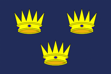
By 1118, Munster had fractured into the Kingdom of Thomond under the O'Briens, the Kingdom of Desmond under the MacCarthy dynasty (Eóganachta), and the short-lived Kingdom of Ormond under the O'Kennedys (another Dalcassian sept). The three crowns of the flag of Munster represent these three late kingdoms.
There was Norman influence from the 14th century, including by the FitzGerald, de Clare and Butler houses, two of whom carved out earldoms within the Lordship of Ireland, the Earls of Desmond eventually becoming independent potentates, while the Earls of Ormond remained closer to England. The O'Brien of Thomond and MacCarthy of Desmond surrendered and regranted sovereignty to the Tudors in 1543 and 1565, joining the Kingdom of Ireland. The impactful Desmond Rebellions, led by the FitzGeralds, soon followed.
The area of Munster was then colonized in the mid to late 16th century by the British plantations of Ireland during the Tudor conquest of Ireland, a group known as the West Country Men played a role in the colonization of Munster, attempts to settle a joint stock colony at Kerrycurrihy in 1568 was made and Richard Grenville also seized lands for colonization at Tracton, to the west of Cork harbour. The Munster plantation was the largest colonial venture of the English at the time.
By the mid-19th century much of the area was hit hard in the Great Famine, especially the west. The province was affected by events in the Irish War of Independence in the early 20th century, and there was a brief Munster Republic during the Irish Civil War.
The Irish leaders Michael Collins and earlier Daniel O'Connell came from families of the old Gaelic Munster gentry.==Culture==
Noted for its traditions in Irish folk music, and with many ancient castles and monasteries in the province, Munster is a tourist destination. During the fifth century, St. Patrick spent seven years founding churches and ordaining priests in Munster, but a fifth-century bishop named Ailbe is the patron saint of Munster.
Map - Munster
Map


Country - Ireland
 |
 |
| Flag of the Republic of Ireland | |
Geopolitically, Ireland is divided between the Republic of Ireland (officially named Ireland), an independent state covering five-sixths of the island, and Northern Ireland, which is part of the United Kingdom. As of 2022, the population of the entire island is just over 7 million, with 5.1 million living in the Republic of Ireland and 1.9 million in Northern Ireland, ranking it the second-most populous island in Europe after Great Britain.
Currency / Language
| ISO | Currency | Symbol | Significant figures |
|---|---|---|---|
| EUR | Euro | € | 2 |
| ISO | Language |
|---|---|
| EN | English language |
| GA | Irish language |


