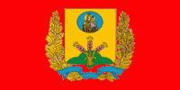
Mogilev Region (Mogilyov Oblast)
 |
 |
Both Mogilev and Gomel Regions suffered severely after the Chernobyl nuclear radioactive reactor catastrophe in April 1986.
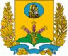
Important cities within the region include Mogilev, Asipovichy and Babruysk.
The Mogilev Region covers a total area of 29100 km2, about 14% of the national total. The oblast's greatest extent from north to south is 150 km, from east to west - 300 km, while the highest point is 239 m above sea level and the lowest at 126 m above sea level.
Many rivers flow through the Mogilev Region including the Dnieper (Dniapro), Berezina, Sozh, Druts, Pronya and Ptsich. The oblast' also has small lakes, the largest being the Zaozerye Lake with a surface area of 0.58 km2. The Chigirin Reservoir on the Druts River has an area of 21.1 km2.
The extreme eastern point of Belarus is situated within the Mogilev Region to the east of the Khotimsk District.
Map - Mogilev Region (Mogilyov Oblast)
Map


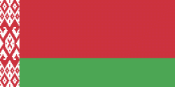
Country - Belarus
 |
 |
| Flag of Belarus | |
Until the 20th century, different states at various times controlled the lands of modern-day Belarus, including Kievan Rus', the Principality of Polotsk, the Grand Duchy of Lithuania, the Polish–Lithuanian Commonwealth, and the Russian Empire. In the aftermath of the Russian Revolution in 1917, different states arose competing for legitimacy amid the Civil War, ultimately ending in the rise of the Byelorussian SSR, which became a founding constituent republic of the Soviet Union in 1922. After the Polish-Soviet War, Belarus lost almost half of its territory to Poland. Much of the borders of Belarus took their modern shape in 1939, when some lands of the Second Polish Republic were reintegrated into it after the Soviet invasion of Poland, and were finalized after World War II. During World War II, military operations devastated Belarus, which lost about a quarter of its population and half of its economic resources. The republic was redeveloped in the post-war years. In 1945, the Byelorussian SSR became a founding member of the United Nations, along with the Soviet Union.
Currency / Language
| ISO | Currency | Symbol | Significant figures |
|---|---|---|---|
| BYN | Belarusian ruble | Br | 2 |
| ISO | Language |
|---|---|
| BE | Belarusian language |
| RU | Russian language |


