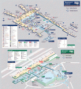
Minneapolis–Saint Paul International Airport (Minneapolis-St Paul International Airport)
Minneapolis–Saint Paul International Airport, also less commonly known as Wold-Chamberlain Field, is a joint civil-military public-use international airport located in Fort Snelling Unorganized Territory, Minnesota, United States. Although situated within the unorganized territory, the airport is centrally located within 10 mi of both downtown Minneapolis and downtown Saint Paul. In addition to primarily hosting commercial flights from major American and some international airlines, the airport is also home to several United States Air Force and Minnesota Air National Guard operations. MSP is the busiest airport in the Upper Midwest.
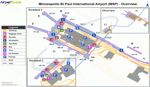
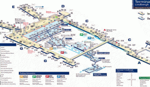
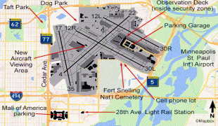
A joint civil-military airport, MSP is home to the Minneapolis–Saint Paul International Airport Joint Air Reserve Station, supporting both Air Force Reserve Command and Air National Guard flight operations. Units stationed there include the 934th Airlift Wing (934 AW). The airport is located in Fort Snelling Unorganized Territory. Small sections of the airport border the city limits of Minneapolis and Richfield. However, under Minnesota state law, the parcel of land covered by the airport is not part of any city or school district. MSP covers 2,930 acres (1,186 ha) of land. The airport generates an estimated $15.9 billion a year for the Twin Cities' economy and supports 87,000 workers.
MSP was a major hub for Northwest Airlines, and still is for its successor, Delta Air Lines. It also serves as the home airport for Minnesota-based Sun Country Airlines. Delta Air Lines and its regional affiliates account for about 70% of the airport's passenger traffic. The airport is operated by the Metropolitan Airports Commission, which also handles the operation of six smaller airports in the region.
What is now known as Minneapolis–Saint Paul International Airport started in 1919 as Speedway Field when several local groups came together to take control of the former bankrupt Twin City Speedway race track. The first hangar was a wooden structure, constructed in 1920 for airmail services. The Minneapolis Park Board took possession of Speedway Field on June 1, 1928, and in 1929, passenger services began. In 1923, the airport was renamed "Wold–Chamberlain Field" for the World War I pilots Ernest Groves Wold and Cyrus Foss Chamberlain. In 1944 the site was renamed to "Minneapolis–St. Paul Metropolitan Airport/Wold-Chamberlain Field", with "International" replacing "Metropolitan" four years later. Today it is rare to see the Wold–Chamberlain portion of the name used anywhere.
| IATA Code | MSP | ICAO Code | KMSP | FAA Code | |
|---|---|---|---|---|---|
| Telephone | Fax | ||||
| Home page | Hyperlink |
Map - Minneapolis–Saint Paul International Airport (Minneapolis-St Paul International Airport)
Map


Country - United_States
 |
 |
| Flag of the United States | |
Indigenous peoples have inhabited the Americas for thousands of years. Beginning in 1607, British colonization led to the establishment of the Thirteen Colonies in what is now the Eastern United States. They quarreled with the British Crown over taxation and political representation, leading to the American Revolution and proceeding Revolutionary War. The United States declared independence on July 4, 1776, becoming the first nation-state founded on Enlightenment principles of unalienable natural rights, consent of the governed, and liberal democracy. The country began expanding across North America, spanning the continent by 1848. Sectional division surrounding slavery in the Southern United States led to the secession of the Confederate States of America, which fought the remaining states of the Union during the American Civil War (1861–1865). With the Union's victory and preservation, slavery was abolished nationally by the Thirteenth Amendment.
Currency / Language
| ISO | Currency | Symbol | Significant figures |
|---|---|---|---|
| USD | United States dollar | $ | 2 |
| ISO | Language |
|---|---|
| EN | English language |
| FR | French language |
| ES | Spanish language |