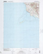
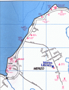
Merizo (Merizo Municipality)
Malesso' is the closest populated place in the United States to the equator.
During the first Spanish missionary efforts on Guam, Malesso' was the site of resistance encouraged by Choco, a Chinese resident of the village. The parish of Malesso' was the second established by the Spanish on Guam. A large population of Chamorros from the Mariana Islands were relocated to the village during Spanish rule.
The village covers an area of 6 sqmi and is located on the shore below the volcanic hills of southern Guam. Places of interest for visitors include Merizo Bell Tower, Malesso' Kombento and Merizo Pier where ferries can be taken to Cocos Island (Guam) Resort. Several popular dive sites are located off the Malesso' coast.
In August 2021, Gov. Lou Leon Guerrero signed a bill officially changing the name of the village from Merizo to Malesso'.
Map - Merizo (Merizo Municipality)
Map


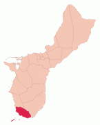

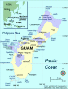


Country - Guam
 |
 |
People born on Guam are American citizens but are politically disenfranchised, having no vote in the United States presidential elections while residing on Guam. Guam delegates to the United States House of Representatives have no vote on the floor. Indigenous Guamanians are the Chamoru, historically known as the Chamorro, who are related to the Austronesian peoples of Malay archipelago, the Philippines, Taiwan, and Polynesia. But unlike most of its neighbors, Chamorro language is not classified as a Micronesian or Polynesian language. Rather, like Palauan, it possibly constitutes an independent branch of the Malayo-Polynesian language family. As of 2022, Guam's population is 168,801. Chamorros are the largest ethnic group, but a minority on the multi-ethnic island. The territory spans 210 mi2 and has a population density of 775 /mi2. The Chamorro people settled the island approximately 3,500 years ago. Portuguese explorer Ferdinand Magellan, while in the service of Spain, was the first European to visit the island on March 6, 1521. Guam was colonized by Spain in 1668. Between the 16th and 18th centuries, Guam was an important stopover for the Spanish Manila Galleons. During the Spanish–American War, the United States captured Guam on June 21, 1898. Under the 1898 Treaty of Paris, Spain ceded Guam to the U.S. effective April 11, 1899.
Currency / Language
| ISO | Currency | Symbol | Significant figures |
|---|---|---|---|
| USD | United States dollar | $ | 2 |
| ISO | Language |
|---|---|
| CH | Chamorro language |
| EN | English language |