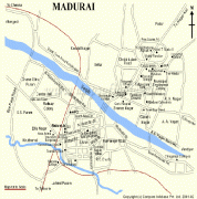
Madurai
Madurai is a major city in the Indian state of Tamil Nadu. It is the cultural capital of Tamil Nadu and the administrative headquarters of Madurai District. As of the 2011 census, it was the third largest Urban agglomeration in Tamil Nadu after Chennai and Coimbatore and the 44th most populated city in India. Located on the banks of River Vaigai, Madurai has been a major settlement for two millennia and has a documented history of more than 2500 years. It is often referred to as "Thoonga Nagaram", meaning "the city that never sleeps".
Madurai is closely associated with the Tamil language. The third Tamil Sangam, a major congregation of Tamil scholars, is said to have been held in the city. The recorded history of the city goes back to the 3rd century BCE, being mentioned by Megasthenes, the Greek ambassador to the Mauryan Empire, and Kautilya, a minister of the Mauryan emperor Chandragupta Maurya. Signs of human settlements and Roman trade links dating back to 300 BCE are evident from excavations by Archeological Survey of India in Manalur. The city is believed to be of significant antiquity and has been ruled, at different times, by the Pandyas, Cholas, Madurai Sultanate, Vijayanagar Empire, Madurai Nayaks, Carnatic kingdom, and the British East India Company British Raj.
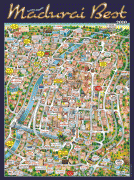
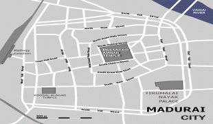
The city has a number of historical monuments, with the Meenakshi Temple and the Thirumalai Nayakkar Mahal being the most prominent. Madurai is an important industrial and educational hub in South Tamil Nadu. The city is home to various automobile, rubber, chemical and granite manufacturing industries.
Madurai has important government educational institutes such as the Madurai Medical College, Homeopathic Medical College, Madurai Law College, Agricultural College and Research Institute. Madurai city is administered by a municipal corporation established in 1971 as per the Municipal Corporation Act. The city covers an area of 147.97 km2 and had a population of 1,470,755 in 2011. The city is also the seat of a bench of the Madras High Court. The Madurai Bench has been functioning since 2004.
According to Iravatham Mahadevan, a 2nd-century BCE Tamil-Brahmi inscription refers to the city as matiray, an Old Tamil word meaning a "walled city".
Madurai is one of the many temple towns in the state which is named after the groves, clusters or forests dominated by a particular variety of a tree or shrub and the same variety of tree or shrub sheltering the presiding deity. The region is believed to have been covered with Kadamba forest and hence called Kadambavanam. The city is referred by various names including "Madurai", "Koodal", "Malligai Maanagar", "Naanmadakoodal" and "Thirualavai". The word Madurai may be derived from Madhura (sweetness) arising out of the divine nectar showered on the city by the Hindu god Siva from his matted hair. Another theory is that Madurai is the derivative of the word Marutham, which refers to the type of landscape of the Sangam age. A town in the neighbouring Dindigul district is called Vada Madurai (North Madurai) and another in Sivagangai district is called Manamadurai. The different names by which the city has been referred to historically are listed in the 7th-century poem Thiruvilayaadal Puraanam written by Paranjothi Munivar. Vaishnava texts refer to Madurai as the "southern Mathura", probably similar to Tenkasi (southern Kashi).
Koodal means an assembly or congregation of scholarly people, referring to the three Tamil Sangams held at Madurai. Naanmadakoodal, meaning the junction of four towers, refers to the four major temples for which Madurai was known for. Tevaram, the 7th- or 8th-century Tamil compositions on Shiva by the three prominent Nayanars (Saivites), namely Appar, Sundarar and Thirugnanasambandar, address the city as Thirualavai.
Madurai is closely associated with the Tamil language. The third Tamil Sangam, a major congregation of Tamil scholars, is said to have been held in the city. The recorded history of the city goes back to the 3rd century BCE, being mentioned by Megasthenes, the Greek ambassador to the Mauryan Empire, and Kautilya, a minister of the Mauryan emperor Chandragupta Maurya. Signs of human settlements and Roman trade links dating back to 300 BCE are evident from excavations by Archeological Survey of India in Manalur. The city is believed to be of significant antiquity and has been ruled, at different times, by the Pandyas, Cholas, Madurai Sultanate, Vijayanagar Empire, Madurai Nayaks, Carnatic kingdom, and the British East India Company British Raj.
The city has a number of historical monuments, with the Meenakshi Temple and the Thirumalai Nayakkar Mahal being the most prominent. Madurai is an important industrial and educational hub in South Tamil Nadu. The city is home to various automobile, rubber, chemical and granite manufacturing industries.
Madurai has important government educational institutes such as the Madurai Medical College, Homeopathic Medical College, Madurai Law College, Agricultural College and Research Institute. Madurai city is administered by a municipal corporation established in 1971 as per the Municipal Corporation Act. The city covers an area of 147.97 km2 and had a population of 1,470,755 in 2011. The city is also the seat of a bench of the Madras High Court. The Madurai Bench has been functioning since 2004.
According to Iravatham Mahadevan, a 2nd-century BCE Tamil-Brahmi inscription refers to the city as matiray, an Old Tamil word meaning a "walled city".
Madurai is one of the many temple towns in the state which is named after the groves, clusters or forests dominated by a particular variety of a tree or shrub and the same variety of tree or shrub sheltering the presiding deity. The region is believed to have been covered with Kadamba forest and hence called Kadambavanam. The city is referred by various names including "Madurai", "Koodal", "Malligai Maanagar", "Naanmadakoodal" and "Thirualavai". The word Madurai may be derived from Madhura (sweetness) arising out of the divine nectar showered on the city by the Hindu god Siva from his matted hair. Another theory is that Madurai is the derivative of the word Marutham, which refers to the type of landscape of the Sangam age. A town in the neighbouring Dindigul district is called Vada Madurai (North Madurai) and another in Sivagangai district is called Manamadurai. The different names by which the city has been referred to historically are listed in the 7th-century poem Thiruvilayaadal Puraanam written by Paranjothi Munivar. Vaishnava texts refer to Madurai as the "southern Mathura", probably similar to Tenkasi (southern Kashi).
Koodal means an assembly or congregation of scholarly people, referring to the three Tamil Sangams held at Madurai. Naanmadakoodal, meaning the junction of four towers, refers to the four major temples for which Madurai was known for. Tevaram, the 7th- or 8th-century Tamil compositions on Shiva by the three prominent Nayanars (Saivites), namely Appar, Sundarar and Thirugnanasambandar, address the city as Thirualavai.
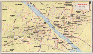
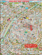
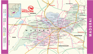
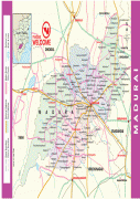
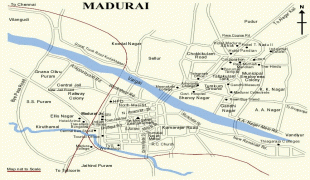
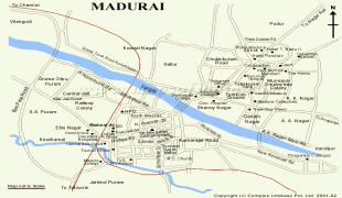
Map - Madurai
Map


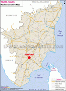
Country - India
 |
 |
| Flag of India | |
Modern humans arrived on the Indian subcontinent from Africa no later than 55,000 years ago. Their long occupation, initially in varying forms of isolation as hunter-gatherers, has made the region highly diverse, second only to Africa in human genetic diversity. Settled life emerged on the subcontinent in the western margins of the Indus river basin 9,000 years ago, evolving gradually into the Indus Valley Civilisation of the third millennium BCE. By, an archaic form of Sanskrit, an Indo-European language, had diffused into India from the northwest. (a) (b) (c), "In Punjab, a dry region with grasslands watered by five rivers (hence ‘panch’ and ‘ab’) draining the western Himalayas, one prehistoric culture left no material remains, but some of its ritual texts were preserved orally over the millennia. The culture is called Aryan, and evidence in its texts indicates that it spread slowly south-east, following the course of the Yamuna and Ganga Rivers. Its elite called itself Arya (pure) and distinguished themselves sharply from others. Aryans led kin groups organized as nomadic horse-herding tribes. Their ritual texts are called Vedas, composed in Sanskrit. Vedic Sanskrit is recorded only in hymns that were part of Vedic rituals to Aryan gods. To be Aryan apparently meant to belong to the elite among pastoral tribes. Texts that record Aryan culture are not precisely datable, but they seem to begin around 1200 BCE with four collections of Vedic hymns (Rg, Sama, Yajur, and Artharva)."
Currency / Language
| ISO | Currency | Symbol | Significant figures |
|---|---|---|---|
| INR | Indian rupee | ₹ | 2 |
| ISO | Language |
|---|---|
| AS | Assamese language |
| BN | Bengali language |
| BH | Bihari languages |
| EN | English language |
| GU | Gujarati language |
| HI | Hindi |
| KN | Kannada language |
| ML | Malayalam language |
| MR | Marathi language |
| OR | Oriya language |
| PA | Panjabi language |
| TA | Tamil language |
| TE | Telugu language |
| UR | Urdu |