Kirakira
The Kirakira Airport is served by Solomon Airlines, which provides flights to Honiara and other destinations. The airport is a grass strip and receives flights four times per week. Solomon Airlines, the national carrier, flies in and out of Kira Kira. It is a 45-minute flight from Honiara. Planes landing at the airport vary in size from a 6-seat Islander to a 36-seat Dash 8 twin turboprop. If there is too much rain, the airstrip can be too muddy to allow planes to safely land.
The capital, KiraKira, is a small township of approximately 3,500 people. The premier, Thomas Weipe, is the local Makira-Ulawa representative for Solomon Islands parliament. His office is in KiraKira. KiraKira does have electricity and running water. The electricity is produced by a diesel generator. There are often periods where there is no power each day for 1–2 hours while the generator is maintained. The town is nestled on the bay opposite the airport. Most people live in traditional Solomon Island houses. There is mobile phone coverage in KiraKira that allows for talk and text communication but not mobile Internet services. The Internet can usually only be accessed at the post office. Despite an annual rainfall in excess of 3 metres, there are challenges associated with securing the water supply for the town. A centerpiece for the community is a full-sized soccer oval.
90% of the population on the island are Christian with various denominations including Roman Catholic, South Pacific Christian and 7th day Adventist churches found in the community. The majority of the population lives in rugged terrain in villages on the slopes of the mountains which are covered in dense jungle and rise along the spine of Makira Island.
A range of languages and dialects spoken in Kirakira. Pidgin English is spoken by the local Islanders. English is the official language used by the staff at the hospital and in the schools.
There are primary and secondary schools in KiraKira. Primary school education is compulsory. There is a large government boarding school on Makira Island that takes students to year 12 from all over Solomon Islands. Students sleep in bunk beds in dormitories that hold about 40 students. The fees at government-funded boarding schools are modest but still a challenge for Solomon Islanders, approximately $2,000SBD (approximately US$250) for board and tuition for a year at a public boarding school in the Solomon Islands. There is no formal tertiary or trade education in Kirakira. Students must leave the island to gain further qualifications after leaving school.
Map - Kirakira
Map


Country - Solomon_Islands
 |
 |
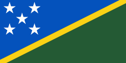
| Flag of the Solomon Islands | |
The islands have been settled since at least some time between 30,000 and 28,800 BCE, with later waves of migrants, notably the Lapita people, mixing and producing the modern indigenous Solomon Islanders population. In 1568, the Spanish navigator Álvaro de Mendaña was the first European to visit them. Though not named by Mendaña, it is believed that the islands were called "the Solomons" by those who later received word of his voyage and mapped his discovery. Mendaña returned decades later, in 1595, and another Spanish expedition, led by Portuguese navigator Pedro Fernandes de Queirós, visited the Solomons in 1606. Britain defined its area of interest in the Solomon Islands archipelago in June 1893, when Captain Gibson, R.N., of HMS Curacoa (1878), declared the southern Solomon Islands a British protectorate. During World War II, the Solomon Islands campaign (1942–1945) saw fierce fighting between the United States, British Commonwealth forces and the Empire of Japan, including the Battle of Guadalcanal.
Currency / Language
| ISO | Currency | Symbol | Significant figures |
|---|---|---|---|
| SBD | Solomon Islands dollar | $ | 2 |
| ISO | Language |
|---|---|
| EN | English language |