Kiev Oblast (Kyiv Oblast)
 |
 |
The population of Kyiv Oblast is Its largest city is Bila Tserkva, with a population over 200,000.
The Chernobyl Exclusion Zone is in the northern part of Kyiv Oblast. It is administered separately from the oblast and public access is prohibited.
Kyiv Oblast was created as part of the Ukrainian Soviet Socialist Republic on February 27, 1932 among the first five original oblasts in Ukraine. It was established on territory that had been known as Ruthenian land.
Earlier historical administrative units that became the territory of the oblast include the Kiev Voivodeship under the Polish–Lithuanian Commonwealth and Grand Duchy of Lithuania, and the Kiev Viceroyalty and Kiev Governorate under the Russian Empire. The northern part of the oblast belongs to the historical region of Polesia (Polissia).
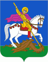
In Kyiv region, there was a specific folk icon-painting style much influenced by the Kyiv Pechersk Lavra painting school. Saints were depicted on the deep purple or black background, their clothes dark, their haloes dark blue, dark green or even black, outlined by thin white dotted contours. The Kyiv region's icons collection is the part of the exhibition of the Museum of Ukrainian home icons in the Historical and cultural complex "The Radomysl Castle".
The current borders of the oblast were set following the Chernobyl disaster in 1986. Administrative oversight of the new city of Slavutych, which was constructed as part of the Chernihiv Oblast, was then transferred to the Kyiv Oblast (see Chernobyl zone below).
On 24 February 2022, Russian Armed Forces invaded Kyiv Oblast as part of its 2022 Russian invasion of Ukraine. Ukraine launched a counter-offensive to retake the region in March 2022. The oblast was declared free of invaders on 2 April 2022 by the Ukrainian Deputy Minister of Defense Hanna Malyar. According to the Ukrainian Ministry of Defense its troops had retaken more than 30 towns and villages around Kyiv. However, on April 9, 2022 the Russians attacked the Oblast again, even destroying a railway station in Bucha.
Map - Kiev Oblast (Kyiv Oblast)
Map


Country - Ukraine
 |
 |
| Flag of Ukraine | |
During the Middle Ages, Ukraine was the site of early Slavic expansion and the area later became a key centre of East Slavic culture under the state of Kievan Rus', which emerged in the 9th century. The state eventually disintegrated into rival regional powers and was ultimately destroyed by the Mongol invasions of the 13th century. The area was then contested, divided, and ruled by a variety of external powers for the next 600 years, including the Polish–Lithuanian Commonwealth, the Austrian Empire, the Ottoman Empire, and the Tsardom of Russia. The Cossack Hetmanate emerged in central Ukraine in the 17th century, but was partitioned between Russia and Poland, and ultimately absorbed by the Russian Empire. Ukrainian nationalism developed, and following the Russian Revolution in 1917, the short-lived Ukrainian People's Republic was formed. The Bolsheviks consolidated control over much of the former empire and established the Ukrainian Soviet Socialist Republic, which became a constituent republic of the Soviet Union when it was formed in 1922. In the early 1930s, millions of Ukrainians died in the Holodomor, a man-made famine. During World War II, Ukraine was devastated by the German occupation.
Currency / Language
| ISO | Currency | Symbol | Significant figures |
|---|---|---|---|
| UAH | Ukrainian hryvnia | â‚´ | 2 |
| ISO | Language |
|---|---|
| HU | Hungarian language |
| PL | Polish language |
| RU | Russian language |
| UK | Ukrainian language |